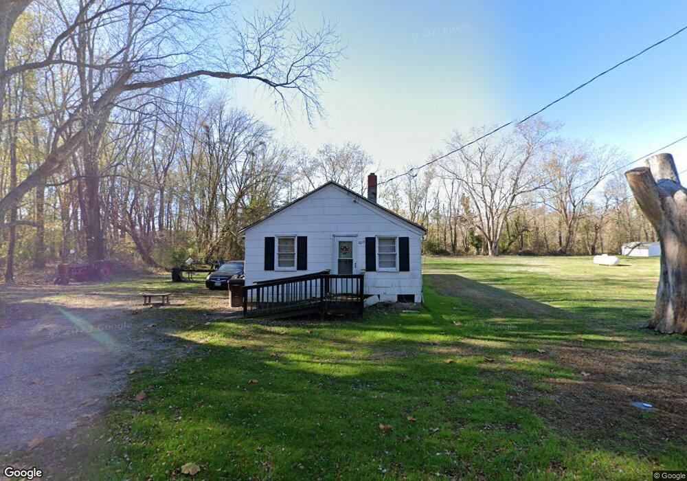
1019 Phillips St Cambridge, MD 21613
Estimated Value: $71,821 - $141,000
Studio
1
Bath
1,050
Sq Ft
$106/Sq Ft
Est. Value
About This Home
This home is located at 1019 Phillips St, Cambridge, MD 21613 and is currently estimated at $111,205, approximately $105 per square foot. 1019 Phillips St is a home located in Dorchester County with nearby schools including Maple Elementary School, Mace's Lane Middle School, and Cambridge-South Dorchester High School.
Ownership History
Date
Name
Owned For
Owner Type
Purchase Details
Closed on
Aug 6, 2025
Sold by
Molock Tyrone Yvon and Ennals Mary Elizabeth
Bought by
Molock Tyrone Yvon and Freeman-Molock Melissa A
Current Estimated Value
Purchase Details
Closed on
Apr 1, 2011
Sold by
Molock Calvin Leander
Bought by
Molock Calvin Leander and Molock Nuton Jacqueline
Purchase Details
Closed on
Mar 2, 2011
Sold by
Molock Calvin Leander
Bought by
Molock Calvin Leander and Molock Nuton Jacqueline
Create a Home Valuation Report for This Property
The Home Valuation Report is an in-depth analysis detailing your home's value as well as a comparison with similar homes in the area
Home Values in the Area
Average Home Value in this Area
Purchase History
| Date | Buyer | Sale Price | Title Company |
|---|---|---|---|
| Molock Tyrone Yvon | -- | None Listed On Document | |
| Molock Tyrone Yvon | -- | None Listed On Document | |
| Molock Calvin Leander | -- | -- | |
| Molock Calvin Leander | -- | -- |
Source: Public Records
Tax History
| Year | Tax Paid | Tax Assessment Tax Assessment Total Assessment is a certain percentage of the fair market value that is determined by local assessors to be the total taxable value of land and additions on the property. | Land | Improvement |
|---|---|---|---|---|
| 2025 | $686 | $36,500 | $6,000 | $30,500 |
| 2024 | $593 | $34,300 | $0 | $0 |
| 2023 | $593 | $32,100 | $0 | $0 |
| 2022 | $1,105 | $29,900 | $6,000 | $23,900 |
| 2021 | $551 | $29,567 | $0 | $0 |
| 2020 | $551 | $29,233 | $0 | $0 |
| 2019 | $551 | $28,900 | $6,000 | $22,900 |
| 2018 | $529 | $28,500 | $0 | $0 |
| 2017 | $522 | $28,100 | $0 | $0 |
| 2016 | -- | $27,700 | $0 | $0 |
| 2015 | -- | $27,700 | $0 | $0 |
| 2014 | -- | $27,700 | $0 | $0 |
Source: Public Records
Map
Nearby Homes
- 1008 Phillips St
- 0 Bradley Ave
- 1303 Colonial Ave
- 812 Bradley Ave
- 909 Pine St
- 802 Allen St
- 825 Ames Ct
- 0 W S Center St
- 824 McBrides Ave
- 622 Washington St
- 800 Center St
- 506 Robbins St
- 610 Washington St
- BTW 800-802 Center St
- 701 Goldsborough Ave
- 636 Douglas St
- 638 Douglas St
- 634 Douglas St
- 810 Washington St
- 807 Bayly Rd
- 1011 Phillips St
- 1020 Phillips St
- 1022 Phillips St
- 1012 Phillips St
- 927 Phillips St
- 929 Phillips St
- 0 Hubbard & Phillips St Unit MDDO2007634
- 0 Hubbard & Phillips St Unit MDDO2006488
- 0 Hubbard & Phillips St Unit MDDO2000950
- 0 8 Lots Hubbard and Phillips St
- 0 W S Hubbard St Unit MDDO2007640
- 0 W S Hubbard St Unit MDDO2007632
- 0 W S Hubbard St Unit MDDO2006494
- 0 W S Hubbard St Unit MDDO2006490
- 0 W S Hubbard St Unit MDDO2000948
- 0 W S Hubbard St Unit MDDO2000934
- 1006 Phillips St
- 923 Phillips St
- 1002 Phillips St
- 704 Bradley Ave
Your Personal Tour Guide
Ask me questions while you tour the home.