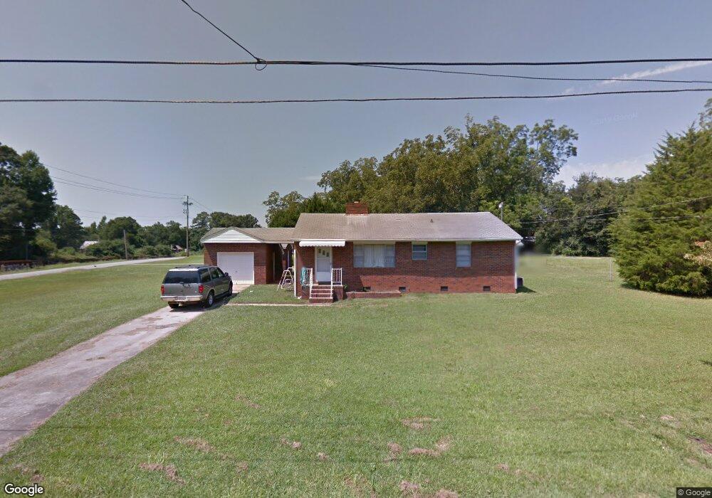
102 Acree St Union Point, GA 30669
Estimated Value: $104,000 - $156,000
2
Beds
2
Baths
1,134
Sq Ft
$120/Sq Ft
Est. Value
About This Home
This home is located at 102 Acree St, Union Point, GA 30669 and is currently estimated at $135,956, approximately $119 per square foot. 102 Acree St is a home located in Greene County with nearby schools including Greene County High School.
Ownership History
Date
Name
Owned For
Owner Type
Purchase Details
Closed on
Feb 4, 2008
Sold by
Yearwood Ronald Frank
Bought by
Yearwood Gargage Inc
Current Estimated Value
Purchase Details
Closed on
Jan 7, 2008
Sold by
Carson James C
Bought by
Yearwood Ronald
Purchase Details
Closed on
Jul 20, 2002
Sold by
Carson James C
Bought by
Yearwood Ronald F---See Will
Purchase Details
Closed on
Mar 2, 1993
Sold by
Buzbee Gladys J
Bought by
Carson James C
Purchase Details
Closed on
Jan 1, 1977
Sold by
Griffith Mary J
Bought by
Buzbee Gladys J
Purchase Details
Closed on
Jan 1, 1966
Bought by
Griffith Mary J
Create a Home Valuation Report for This Property
The Home Valuation Report is an in-depth analysis detailing your home's value as well as a comparison with similar homes in the area
Purchase History
| Date | Buyer | Sale Price | Title Company |
|---|---|---|---|
| Yearwood Gargage Inc | -- | -- | |
| Yearwood Ronald | -- | -- | |
| Yearwood Ronald F---See Will | -- | -- | |
| Carson James C | $37,000 | -- | |
| Buzbee Gladys J | -- | -- | |
| Griffith Mary J | -- | -- |
Source: Public Records
Tax History
| Year | Tax Paid | Tax Assessment Tax Assessment Total Assessment is a certain percentage of the fair market value that is determined by local assessors to be the total taxable value of land and additions on the property. | Land | Improvement |
|---|---|---|---|---|
| 2025 | $1,000 | $34,400 | $4,280 | $30,120 |
| 2024 | $941 | $31,920 | $4,280 | $27,640 |
| 2023 | $710 | $31,320 | $4,280 | $27,040 |
| 2022 | $674 | $29,240 | $4,280 | $24,960 |
| 2021 | $836 | $43,240 | $4,280 | $38,960 |
| 2020 | $564 | $19,880 | $2,680 | $17,200 |
| 2019 | $582 | $19,880 | $2,680 | $17,200 |
| 2018 | $444 | $19,880 | $2,680 | $17,200 |
| 2017 | $520 | $19,622 | $2,700 | $16,922 |
| 2016 | $542 | $20,384 | $2,700 | $17,684 |
| 2015 | $509 | $20,383 | $2,700 | $17,684 |
| 2014 | $490 | $18,872 | $2,700 | $16,172 |
Source: Public Records
Map
Nearby Homes
- 509 Carlton Ave
- 405 Crawfordville Rd
- 202 Veazey St
- 1160 Moody St
- 0 Woodland Ct Unit 10543600
- 324 N Rhodes St
- 1241 Old Siloam Rd
- 5401 Union Point Hwy
- 1201 Buffalo Lick Rd
- 0 Buffalo Lick Rd Unit 10551234
- 0 Buffalo Lick Rd Unit 10551325
- 215 Hunter St
- 1071 Alexander St
- 1581 Highway 77 S
- 000 Washington Hwy
- 1581 Highway 77 S Hwy
- 0 Washington Hwy Unit 10686255
- 1251 Brick House Rd
- 1251 Brickhouse Rd
- 1251 Adams Rd
- 42.35 ACRES Penfield Rd Rd
- 93 Carlton Ave
- 101 Acree St
- 105 Acree St
- 101 Hendry St
- 106 Acre St
- 106 Acree St
- 105 Hendry St
- 33 ac Union Point Hwy
- 103 Hendry St
- 107 Acree St
- 108 Acree St
- 102 Mckinley St
- 104 Mckinley St
- 5081 Lamb Ave
- 107 Hendry St
- 106 Mckinley St
- 5091 Lamb Ave
- 100 Hendry St
- 104 Hendry St
Your Personal Tour Guide
Ask me questions while you tour the home.