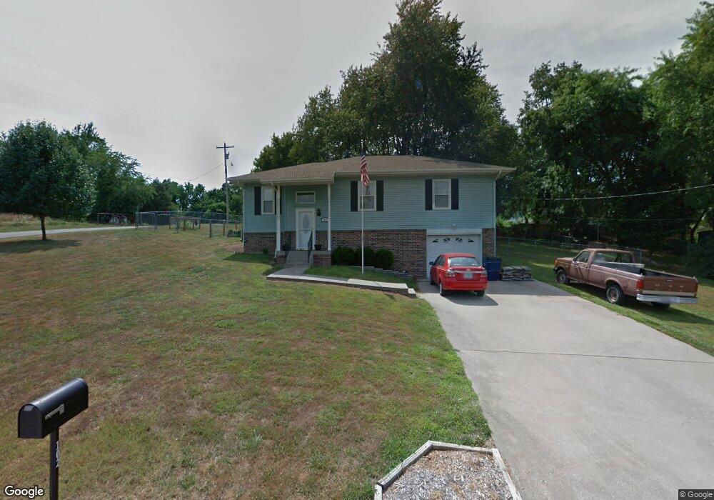
102 Amber St Cassville, MO 65625
Estimated Value: $143,411 - $187,000
--
Bed
--
Bath
1,008
Sq Ft
$162/Sq Ft
Est. Value
About This Home
This home is located at 102 Amber St, Cassville, MO 65625 and is currently estimated at $163,353, approximately $162 per square foot. 102 Amber St is a home with nearby schools including Eunice Thomas Elementary School, Cassville Intermediate School, and Cassville Middle School.
Ownership History
Date
Name
Owned For
Owner Type
Purchase Details
Closed on
Oct 25, 2005
Sold by
Mcmanus James W and Mcmanus Grace A
Bought by
Barrington Steven M and Barrington Cynthia A
Current Estimated Value
Home Financials for this Owner
Home Financials are based on the most recent Mortgage that was taken out on this home.
Original Mortgage
$93,566
Outstanding Balance
$50,827
Interest Rate
5.9%
Mortgage Type
New Conventional
Estimated Equity
$112,526
Create a Home Valuation Report for This Property
The Home Valuation Report is an in-depth analysis detailing your home's value as well as a comparison with similar homes in the area
Home Values in the Area
Average Home Value in this Area
Purchase History
| Date | Buyer | Sale Price | Title Company |
|---|---|---|---|
| Barrington Steven M | -- | Bcat |
Source: Public Records
Mortgage History
| Date | Status | Borrower | Loan Amount |
|---|---|---|---|
| Open | Barrington Steven M | $93,566 |
Source: Public Records
Tax History Compared to Growth
Tax History
| Year | Tax Paid | Tax Assessment Tax Assessment Total Assessment is a certain percentage of the fair market value that is determined by local assessors to be the total taxable value of land and additions on the property. | Land | Improvement |
|---|---|---|---|---|
| 2025 | $650 | $15,428 | $2,451 | $12,977 |
| 2024 | $650 | $14,250 | $2,451 | $11,799 |
| 2023 | $650 | $14,250 | $2,451 | $11,799 |
| 2022 | $630 | $13,813 | $2,014 | $11,799 |
| 2021 | $633 | $13,813 | $2,014 | $11,799 |
| 2020 | $633 | $13,813 | $2,014 | $11,799 |
| 2018 | $619 | $13,813 | $2,014 | $11,799 |
| 2017 | $617 | $13,813 | $2,014 | $11,799 |
| 2016 | $573 | $12,673 | $1,786 | $10,887 |
| 2015 | -- | $12,673 | $1,786 | $10,887 |
| 2014 | -- | $12,673 | $1,786 | $10,887 |
| 2012 | -- | $0 | $0 | $0 |
Source: Public Records
Map
Nearby Homes
- 1421 Oakhill Dr
- 1408 Nottingham Dr
- 000 Luney Dr
- 1103 Townsend St
- 000 Townsend West 9th
- 303 Melton Way
- 106 Mountain St
- 3110 Main St
- 1605 N Main St
- 000 State Highway 86
- Tbd State Highway 76
- 1112 Harold St
- 129 Robinhood Dr
- 75 Sycamore Dr
- 34 Sunset St
- 83 Main St
- 1400 Old Exeter Rd
- 1605 Chappell Dr
- Lot 4 State Highway 112
- Lot 2 State Highway 112
- 1403 Maple Ridge
- 1401 Maple Ridge Rd
- 1405 Maple Ridge
- 104 Amber St
- 1402 Maple Ridge Rd
- 1402 Maple Ridge
- 1406 Maple Ridge
- 106 Amber St
- 1404 Maple Ridge
- 108 Amber St
- 1408 Maple Ridge
- 103 Amber St
- 105 Amber St
- 110 Amber St
- 107 Amber St
- 1410 Maple Ridge
- 104 Array St
- 102 Array St
- 106 Array St
- 102 Aaray St