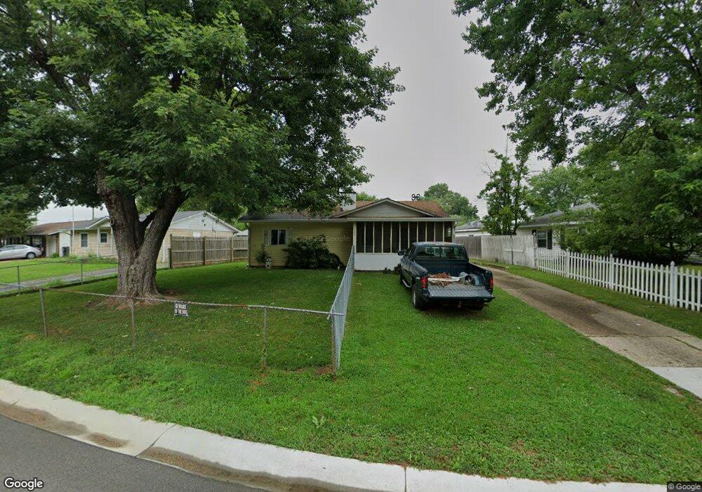
102 Brookside Dr Whiteland, IN 46184
Estimated Value: $194,000 - $201,171
About This Home
This home is located at 102 Brookside Dr, Whiteland, IN 46184 and is currently estimated at $196,293, approximately $177 per square foot. 102 Brookside Dr is a home located in Johnson County with nearby schools including Break-O-Day Elementary School, Clark-Pleasant Middle School, and Whiteland Community High School.
Ownership History
We collect this data history from publicly available records. To have your information removed, we recommend requesting removal directly through your county’s website.
Purchase Details
Home Financials for this Owner
Home Financials are based on the most recent Mortgage that was taken out on this home.Home Values in the Area
Average Home Value in this Area
Purchase History
We collect this data history from publicly available records. To have your information removed, we recommend requesting removal directly through your county’s website.
| Date | Buyer | Sale Price | Title Company |
|---|---|---|---|
| -- | Security Title |
Mortgage History
We collect this data history from publicly available records. To have your information removed, we recommend requesting removal directly through your county’s website.
| Date | Status | Borrower | Loan Amount |
|---|---|---|---|
| Previous Owner | $79,532 |
Tax History
We collect this data history from publicly available records. To have your information removed, we recommend requesting removal directly through your county’s website.
| Year | Tax Paid | Tax Assessment Tax Assessment Total Assessment is a certain percentage of the fair market value that is determined by local assessors to be the total taxable value of land and additions on the property. | Land | Improvement |
|---|---|---|---|---|
| 2025 | $1,243 | $155,300 | $42,000 | $113,300 |
| 2024 | $1,285 | $144,400 | $42,000 | $102,400 |
| 2023 | $1,273 | $139,100 | $42,000 | $97,100 |
| 2022 | $1,326 | $128,400 | $35,000 | $93,400 |
| 2021 | $1,096 | $114,300 | $35,000 | $79,300 |
| 2020 | $611 | $83,400 | $21,000 | $62,400 |
| 2019 | $526 | $78,300 | $16,000 | $62,300 |
| 2018 | $510 | $77,000 | $13,500 | $63,500 |
| 2017 | $504 | $76,200 | $13,500 | $62,700 |
| 2016 | $447 | $70,800 | $13,500 | $57,300 |
| 2014 | $441 | $67,600 | $14,400 | $53,200 |
| 2013 | $441 | $69,300 | $14,400 | $54,900 |
Map
- 115 Brookside Dr
- 217 Crestwood Dr
- 153 Parkview Dr
- 514 Elmhurst Place
- 188 Lynwood Dr
- 242 Hollybrook Dr
- 0 E 700 N Unit MBR22036500
- 603 Oakland Way
- 211 Whiteland Rd
- 96 Mission Terrace Dr
- 271 Dyson Dr
- 641 Saraina Ln
- 121 Halldale Dr
- 624 Sweetbriar Ave
- 829 Delbrook Dr
- 903 Sawmill Rd
- 129 Larimar Way
- 4810 N Centerline Rd
- 147 Wild Turkey Run
- 269 Switchgrass Ln
- 40 Brookside Dr
- 46 Brookside Dr
- 30 Brookside Dr
- 26 Brookside Dr
- 37 Parkview Dr
- 22 Brookside Dr
- 47 Brookside Dr
- 43 Parkview Dr
- 41 Brookside Dr
- 108 Brookside Dr
- 53 Brookside Dr
- 29 Brookside Dr
- 114 Brookside Dr
- 35 Brookside Dr
- 49 Parkview Dr
- 23 Brookside Dr
- 103 Brookside Dr
- 17 Parkview Dr
- 32 Parkview Dr
- 120 Brookside Dr
Ask me questions while you tour the home.