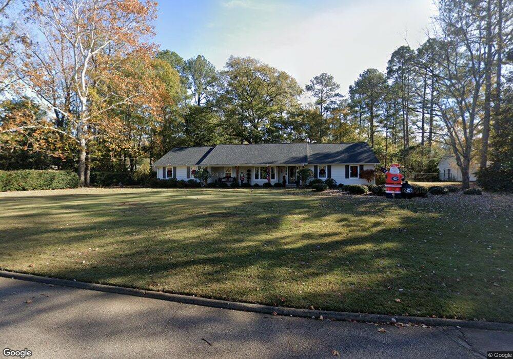
102 Brookwood Dr West Point, GA 31833
Estimated Value: $264,000 - $301,000
4
Beds
5
Baths
2,463
Sq Ft
$115/Sq Ft
Est. Value
About This Home
This home is located at 102 Brookwood Dr, West Point, GA 31833 and is currently estimated at $283,485, approximately $115 per square foot. 102 Brookwood Dr is a home located in Harris County with nearby schools including New Mountain Hill Elementary School, Harris County Carver Middle School, and Creekside School.
Ownership History
Date
Name
Owned For
Owner Type
Purchase Details
Closed on
Sep 24, 2004
Sold by
Mcdiarmid Samuel Newton
Bought by
Sanders Calvin Craig and Sanders Andrea I
Current Estimated Value
Purchase Details
Closed on
Jun 22, 2001
Bought by
Mcdiarmid Samuel Newton
Create a Home Valuation Report for This Property
The Home Valuation Report is an in-depth analysis detailing your home's value as well as a comparison with similar homes in the area
Home Values in the Area
Average Home Value in this Area
Purchase History
| Date | Buyer | Sale Price | Title Company |
|---|---|---|---|
| Sanders Calvin Craig | $163,300 | -- | |
| Mcdiarmid Samuel Newton | $150,000 | -- |
Source: Public Records
Tax History Compared to Growth
Tax History
| Year | Tax Paid | Tax Assessment Tax Assessment Total Assessment is a certain percentage of the fair market value that is determined by local assessors to be the total taxable value of land and additions on the property. | Land | Improvement |
|---|---|---|---|---|
| 2025 | $2,263 | $75,281 | $8,000 | $67,281 |
| 2024 | $2,106 | $70,570 | $8,000 | $62,570 |
| 2023 | $1,069 | $70,410 | $8,000 | $62,410 |
| 2022 | $1,420 | $65,897 | $8,000 | $57,897 |
| 2021 | $1,445 | $64,316 | $8,000 | $56,316 |
| 2020 | $1,445 | $64,316 | $8,000 | $56,316 |
| 2019 | $1,381 | $64,316 | $8,000 | $56,316 |
| 2018 | $1,416 | $63,526 | $8,000 | $55,526 |
| 2017 | $1,416 | $63,526 | $8,000 | $55,526 |
| 2016 | $1,313 | $62,920 | $8,000 | $54,920 |
| 2015 | $1,364 | $65,086 | $8,000 | $57,086 |
| 2014 | $1,416 | $67,251 | $8,000 | $59,251 |
| 2013 | -- | $67,250 | $8,000 | $59,250 |
Source: Public Records
Map
Nearby Homes
- 128 Highland Dr
- 112 Hillcrest Rd
- 608 S 1st Ave
- 311 E 4th St
- 1223 E 3rd Ave
- 612 S 3rd Ave
- 804 E 6th St
- 1403 S Jennings Ave
- 509 Cleveland St
- 314 S 6th Ave
- 1812 26th St
- 302 N 6th Ave
- 902 S Jennings Ave
- 713 Avenue H
- 514 N 8th Ave
- 0 Arrowhead Dr Unit 10451860
- 806 N 5th St
- 712 4th Ave
- 1006 S 5th St
- 2811 16th Ave
- 101 Tyler Terrace
- 97 Hamilton Dr
- 99 Hamilton Dr
- 94 Highland Dr
- 102 Tyler Terrace
- 95 Hamilton Dr
- 97 Highland Dr
- 103 Tyler Terrace
- 106 Tyler Terrace
- 201 Hamilton Dr
- 93 Hamilton Dr
- 95 Highland Dr
- 105 Tyler Terrace
- 96 Hamilton Dr
- 93 Highland Dr
- 94 Hamilton Dr
- 101 Highland Dr
- 205 Hamilton Dr
- 108 Tyler Terrace Unit 13
- 108 Tyler Terrace