Estimated Value: $302,168 - $317,000
4
Beds
3
Baths
2,716
Sq Ft
$115/Sq Ft
Est. Value
About This Home
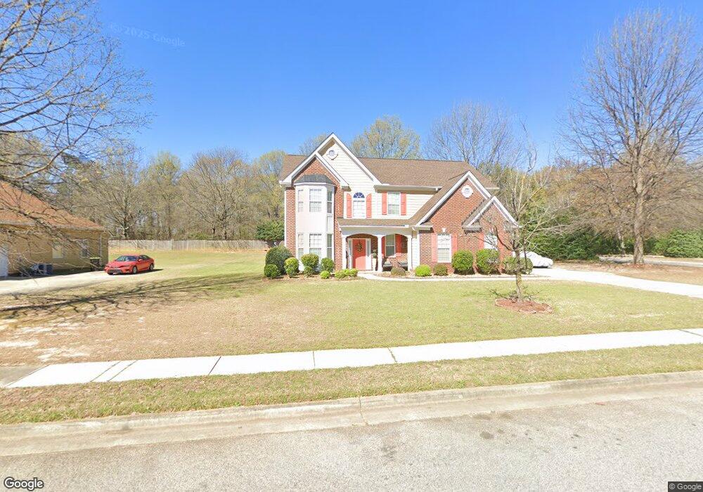
This home is located at 102 Carnegie Way, Byron, GA 31008 and is currently estimated at $311,292, approximately $114 per square foot. 102 Carnegie Way is a home located in Peach County with nearby schools including Byron Elementary School, Byron Middle School, and Peach County High School.
Ownership History
Date
Name
Owned For
Owner Type
Purchase Details
Closed on
Sep 18, 2006
Sold by
D R Horton Inc
Bought by
Parker Maurice A and Parker Patricia D
Current Estimated Value
Home Financials for this Owner
Home Financials are based on the most recent Mortgage that was taken out on this home.
Original Mortgage
$189,422
Outstanding Balance
$110,206
Interest Rate
6.48%
Mortgage Type
VA
Estimated Equity
$201,086
Purchase Details
Closed on
Jun 14, 2006
Sold by
Cumberland Shores Llc
Bought by
D R Horton Inc
Purchase Details
Closed on
May 18, 2006
Sold by
Cumberland Shores Llc
Bought by
D R Horton Inc
Purchase Details
Closed on
Jan 3, 2003
Bought by
Cumberland Shores Llc
Create a Home Valuation Report for This Property
The Home Valuation Report is an in-depth analysis detailing your home's value as well as a comparison with similar homes in the area
Home Values in the Area
Average Home Value in this Area
Purchase History
| Date | Buyer | Sale Price | Title Company |
|---|---|---|---|
| Parker Maurice A | $185,436 | -- | |
| D R Horton Inc | $214,500 | -- | |
| D R Horton Inc | $214,500 | -- | |
| Cumberland Shores Llc | -- | -- |
Source: Public Records
Mortgage History
| Date | Status | Borrower | Loan Amount |
|---|---|---|---|
| Open | Parker Maurice A | $189,422 |
Source: Public Records
Tax History
| Year | Tax Paid | Tax Assessment Tax Assessment Total Assessment is a certain percentage of the fair market value that is determined by local assessors to be the total taxable value of land and additions on the property. | Land | Improvement |
|---|---|---|---|---|
| 2025 | -- | $124,640 | $13,960 | $110,680 |
| 2024 | -- | $112,360 | $13,720 | $98,640 |
| 2023 | $44 | $111,200 | $11,000 | $100,200 |
| 2022 | $3,991 | $98,840 | $11,000 | $87,840 |
| 2021 | $3,217 | $79,680 | $8,800 | $70,880 |
| 2020 | $2,960 | $73,320 | $8,800 | $64,520 |
| 2019 | $2,973 | $73,320 | $8,800 | $64,520 |
| 2018 | $0 | $65,320 | $8,800 | $56,520 |
| 2017 | $0 | $65,320 | $8,800 | $56,520 |
| 2016 | $1,998 | $65,320 | $8,800 | $56,520 |
| 2015 | $2,001 | $65,320 | $8,800 | $56,520 |
| 2014 | $2,004 | $65,320 | $8,800 | $56,520 |
| 2013 | -- | $65,320 | $8,800 | $56,520 |
Source: Public Records
Map
Nearby Homes
- 252 Shantz Way Unit (LOT A43)
- 252 Shantz Way
- 250 Shantz Way
- 250 Shantz Way Unit LOT A42
- 246 Shantz Way Unit (LOT A40)
- 246 Shantz Way
- 262 Shantz Way Unit (LOT A48)
- 0 Peavy Rd
- 206 Christopher Dr
- 106 Christopher Dr
- 0 W White West Rd
- 174 Majestic Oak Cir
- 106 Gassett Ct
- 126 Early Dr
- 118 Early Dr
- 123 Early Dr
- 105 Early Dr
- 212 Eric Ct
- 121 Early Dr
- 202 Eric Ct
- 104 Carnegie Way
- 101 Carnegie Way
- 106 Carnegie Way
- 103 Dungeness Dr
- 103 Carnegie Way
- 105 Carnegie Way
- 108 Carnegie Way
- 201 Dungeness Dr
- 102 Oyster Trail
- 104 Oyster Trail
- 107 Carnegie Way
- 203 Dungeness Dr
- 110 Carnegie Way
- 109 Carnegie Way
- 205 Dungeness Dr
- 112 Carnegie Way
- 108 Oyster Trail
- 101 Oyster Trail
- 103 Oyster Trail
- 103 Coastal Ct
Your Personal Tour Guide
Ask me questions while you tour the home.