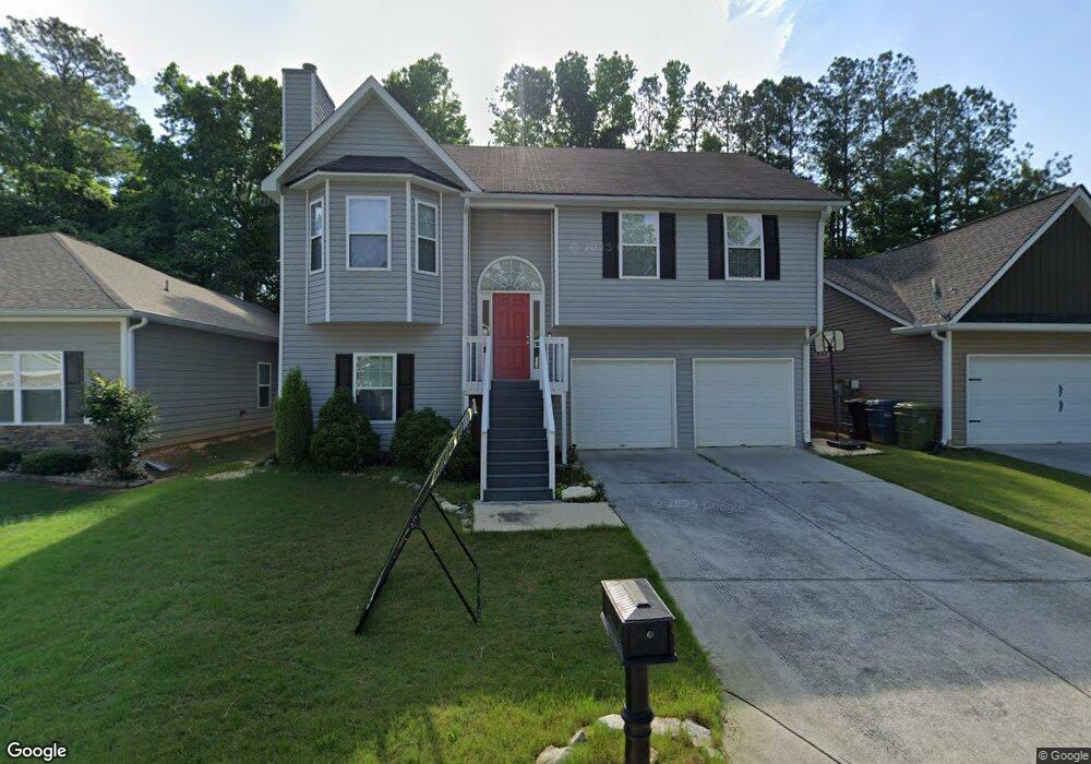
102 Deese Ct Carrollton, GA 30117
Estimated Value: $262,631 - $336,000
5
Beds
2
Baths
1,242
Sq Ft
$236/Sq Ft
Est. Value
About This Home
This home is located at 102 Deese Ct, Carrollton, GA 30117 and is currently estimated at $292,658, approximately $235 per square foot. 102 Deese Ct is a home located in Carroll County with nearby schools including Carrollton Elementary School, Carrollton Upper Elementary School, and Carrollton Middle School.
Ownership History
Date
Name
Owned For
Owner Type
Purchase Details
Closed on
Jun 13, 2016
Sold by
Shockley Realty & Development
Bought by
Clifford Karen and Clifford Robert
Current Estimated Value
Home Financials for this Owner
Home Financials are based on the most recent Mortgage that was taken out on this home.
Original Mortgage
$131,920
Outstanding Balance
$105,096
Interest Rate
3.6%
Estimated Equity
$187,562
Purchase Details
Closed on
Mar 11, 2016
Sold by
Hamilton State Bank
Bought by
Shockley Realty & Development
Purchase Details
Closed on
Jan 6, 2015
Sold by
Ca Associates Llc
Bought by
Hamilton State Bank
Create a Home Valuation Report for This Property
The Home Valuation Report is an in-depth analysis detailing your home's value as well as a comparison with similar homes in the area
Home Values in the Area
Average Home Value in this Area
Purchase History
| Date | Buyer | Sale Price | Title Company |
|---|---|---|---|
| Clifford Karen | -- | -- | |
| Shockley Realty & Development | $88,000 | -- | |
| Hamilton State Bank | $98,356 | -- |
Source: Public Records
Mortgage History
| Date | Status | Borrower | Loan Amount |
|---|---|---|---|
| Open | Clifford Karen | $131,920 | |
| Closed | Clifford Karen | -- |
Source: Public Records
Tax History Compared to Growth
Tax History
| Year | Tax Paid | Tax Assessment Tax Assessment Total Assessment is a certain percentage of the fair market value that is determined by local assessors to be the total taxable value of land and additions on the property. | Land | Improvement |
|---|---|---|---|---|
| 2024 | $2,483 | $104,322 | $6,000 | $98,322 |
| 2023 | $2,483 | $95,413 | $6,000 | $89,413 |
| 2022 | $2,020 | $77,768 | $6,000 | $71,768 |
| 2021 | $1,784 | $67,537 | $6,000 | $61,537 |
| 2020 | $1,619 | $60,270 | $6,000 | $54,270 |
| 2019 | $1,540 | $56,208 | $6,000 | $50,208 |
| 2018 | $1,774 | $59,288 | $6,000 | $53,288 |
| 2017 | $1,463 | $48,621 | $6,000 | $42,621 |
| 2016 | $1,190 | $48,621 | $6,000 | $42,621 |
| 2015 | $1,083 | $35,064 | $6,000 | $29,064 |
| 2014 | $1,088 | $35,064 | $6,000 | $29,064 |
Source: Public Records
Map
Nearby Homes
- 119 Oxford Square
- 114 Green Point Way
- 123 Autumn Glen Dr
- 201 Stewart St
- 325 Almon Rd
- 120 Stewart St
- 123 Cedar Park Way
- 541 N White St
- 322 Cedar St
- 111 Lakeview Dr
- 777 College St
- 114 Bennett Cir
- 103 W Chandler St
- 0 Burns Rd Unit LOT 2 10571612
- 0 Burns Rd Unit LOT 3 10571635
- 0 Burns Rd Unit LOT 1 10571595
- 0 Burns Rd Unit 148013
- 0 Carroll Cir Unit LOTS 4-8 10571562
- 816 Stewart St
- 110 Town Walk Ln
- 104 Deese Ct Unit Phs 2
- 104 Deese Ct
- 100 Deese Ct
- 100 Deese Ct Unit 20
- 106 Deese Ct Unit Phase 2
- 106 Deese Ct
- 109 Commercial Ave
- 108 Deese Ct
- 101 Deese Ct
- 103 Deese Ct
- 111 Commercial Ave
- 105 Deese Ct
- 110 Deese Ct
- 117 Orchard St
- 107 Deese Ct
- 119 Orchard St
- 115 Orchard St
- 112 Deese Ct
- 109 Deese Ct
- 104 Frankford Way