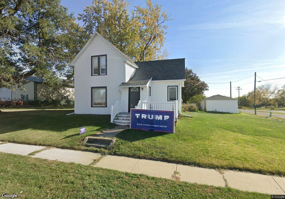
102 E Division St Orient, IA 50858
Estimated Value: $109,000 - $142,000
3
Beds
1
Bath
919
Sq Ft
$132/Sq Ft
Est. Value
About This Home
This home is located at 102 E Division St, Orient, IA 50858 and is currently estimated at $120,895, approximately $131 per square foot. 102 E Division St is a home located in Adair County with nearby schools including Orient Elementary School and Orient-Macksburg Senior High School.
Ownership History
Date
Name
Owned For
Owner Type
Purchase Details
Closed on
Aug 16, 2019
Sold by
Cooley Michael E and Cooley Crystal M
Bought by
Madison Joshua J
Current Estimated Value
Home Financials for this Owner
Home Financials are based on the most recent Mortgage that was taken out on this home.
Original Mortgage
$82,450
Outstanding Balance
$72,211
Interest Rate
3.7%
Mortgage Type
New Conventional
Estimated Equity
$48,684
Create a Home Valuation Report for This Property
The Home Valuation Report is an in-depth analysis detailing your home's value as well as a comparison with similar homes in the area
Purchase History
| Date | Buyer | Sale Price | Title Company |
|---|---|---|---|
| Madison Joshua J | -- | -- |
Source: Public Records
Mortgage History
| Date | Status | Borrower | Loan Amount |
|---|---|---|---|
| Open | Madison Joshua J | $82,450 |
Source: Public Records
Tax History
| Year | Tax Paid | Tax Assessment Tax Assessment Total Assessment is a certain percentage of the fair market value that is determined by local assessors to be the total taxable value of land and additions on the property. | Land | Improvement |
|---|---|---|---|---|
| 2025 | $1,238 | $97,180 | $10,890 | $86,290 |
| 2024 | $1,238 | $87,710 | $8,710 | $79,000 |
| 2023 | $1,190 | $87,710 | $8,710 | $79,000 |
| 2022 | $1,132 | $67,430 | $6,970 | $60,460 |
| 2021 | $1,132 | $67,430 | $6,970 | $60,460 |
| 2020 | $968 | $48,730 | $6,970 | $41,760 |
| 2019 | $834 | $50,167 | $0 | $0 |
| 2018 | $882 | $50,167 | $0 | $0 |
| 2017 | $882 | $44,198 | $0 | $0 |
| 2016 | $966 | $44,198 | $4,485 | $39,713 |
| 2015 | $966 | $43,850 | $0 | $0 |
| 2014 | $936 | $43,850 | $0 | $0 |
Source: Public Records
Map
Nearby Homes
- 107 N Eugene St
- 3088 Jordan Ave
- 3096 310th St
- 2543 Trenton Ave
- 506 SE 4th St
- xxx SW 2nd St
- 309 SE 4th St
- 413 SW 3rd St
- 207 SE Kent St
- 709 NE 6th St
- 3280 260th St
- 1565 Cherry Street Rd
- 1412 Elm Dr
- 3 SW Corner of Townline St & N Su Unit Lots
- 1565 330th St
- 1401 N Elm St
- 501 College Dr
- 1010 N Spruce St
- 1011 Crest Dr
- 1107 W Prairie St
Your Personal Tour Guide
Ask me questions while you tour the home.