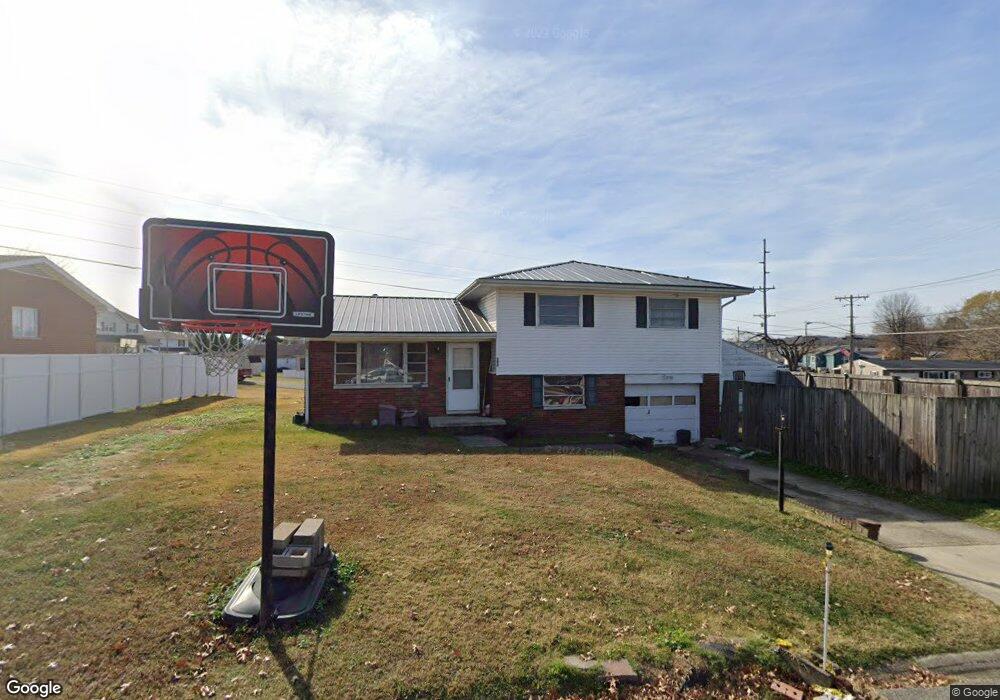
102 Franklin St South Point, OH 45680
Estimated Value: $176,000 - $202,000
4
Beds
2
Baths
1,032
Sq Ft
$183/Sq Ft
Est. Value
About This Home
This home is located at 102 Franklin St, South Point, OH 45680 and is currently estimated at $188,428, approximately $182 per square foot. 102 Franklin St is a home located in Lawrence County with nearby schools including South Point High School.
Ownership History
Date
Name
Owned For
Owner Type
Purchase Details
Closed on
Sep 29, 2020
Sold by
Nease Billy J and Estate Of Myrna J Nease Brian
Bought by
Bb & T Properties Llc
Current Estimated Value
Purchase Details
Closed on
May 5, 2014
Sold by
Nease Darren Blaine and Nease Sheila K
Bought by
Nease Brian Scott and Nease Christina D
Purchase Details
Closed on
Feb 24, 2004
Sold by
Nease Myrna J
Bought by
Nease Darren Blaine Bri
Purchase Details
Closed on
Jun 23, 2000
Sold by
Nease Billy J and Nease Miran
Bought by
Nease Myrna J
Create a Home Valuation Report for This Property
The Home Valuation Report is an in-depth analysis detailing your home's value as well as a comparison with similar homes in the area
Home Values in the Area
Average Home Value in this Area
Purchase History
| Date | Buyer | Sale Price | Title Company |
|---|---|---|---|
| Bb & T Properties Llc | $46,000 | None Available | |
| Nease Brian Scott | -- | None Available | |
| Nease Darren Blaine Bri | -- | -- | |
| Nease Myrna J | -- | -- |
Source: Public Records
Tax History Compared to Growth
Tax History
| Year | Tax Paid | Tax Assessment Tax Assessment Total Assessment is a certain percentage of the fair market value that is determined by local assessors to be the total taxable value of land and additions on the property. | Land | Improvement |
|---|---|---|---|---|
| 2024 | -- | $41,130 | $8,250 | $32,880 |
| 2023 | $1,447 | $41,130 | $8,250 | $32,880 |
| 2022 | $1,443 | $41,130 | $8,250 | $32,880 |
| 2021 | $1,249 | $33,500 | $6,210 | $27,290 |
| 2020 | $1,262 | $33,500 | $6,210 | $27,290 |
| 2019 | $1,255 | $33,500 | $6,210 | $27,290 |
| 2018 | $1,164 | $30,460 | $5,650 | $24,810 |
| 2017 | $1,162 | $30,460 | $5,650 | $24,810 |
| 2016 | $1,090 | $30,460 | $5,650 | $24,810 |
| 2015 | $1,081 | $28,330 | $5,650 | $22,680 |
| 2014 | $1,054 | $28,330 | $5,650 | $22,680 |
| 2013 | $953 | $28,330 | $5,650 | $22,680 |
Source: Public Records
Map
Nearby Homes
- 205 Michael St
- 105 Orchard Dr
- 119 Meadow Ln
- 408 Brubaker Dr
- 609 4th St E
- 101 Henray Dr
- 0 Twp R 135
- 00 County Road 1
- 404 Township Road 135
- 0 Township Road 135
- 102 Park Ave
- 110 Kitts Ln
- 1524 Beech St
- 217 17th St
- 304 15th St
- 1104 Beech St
- 312 13th St
- 1184 County Road 18
- 2708 Panola St
- 0 Township Road 161 Unit 182331
- 104 Franklin St
- 508 N Kenova Rd
- 215 Michael St
- 103 Franklin St
- 106 Franklin St
- 506 N Kenova Rd
- 506 N Kenova Rd
- 506 N Kenova Rd Unit B
- 506 N Kenova Rd
- 506 N Kenova Rd Unit C
- 601 N Kenova Rd
- 603 N Kenova Rd
- 105 Franklin St
- 213 Michael St
- 105 Shelby Ave
- 602 N Kenova Rd
- 108 Franklin St
- 107 Amanda St
- 107 Franklin St
- 102 Meadow Ln