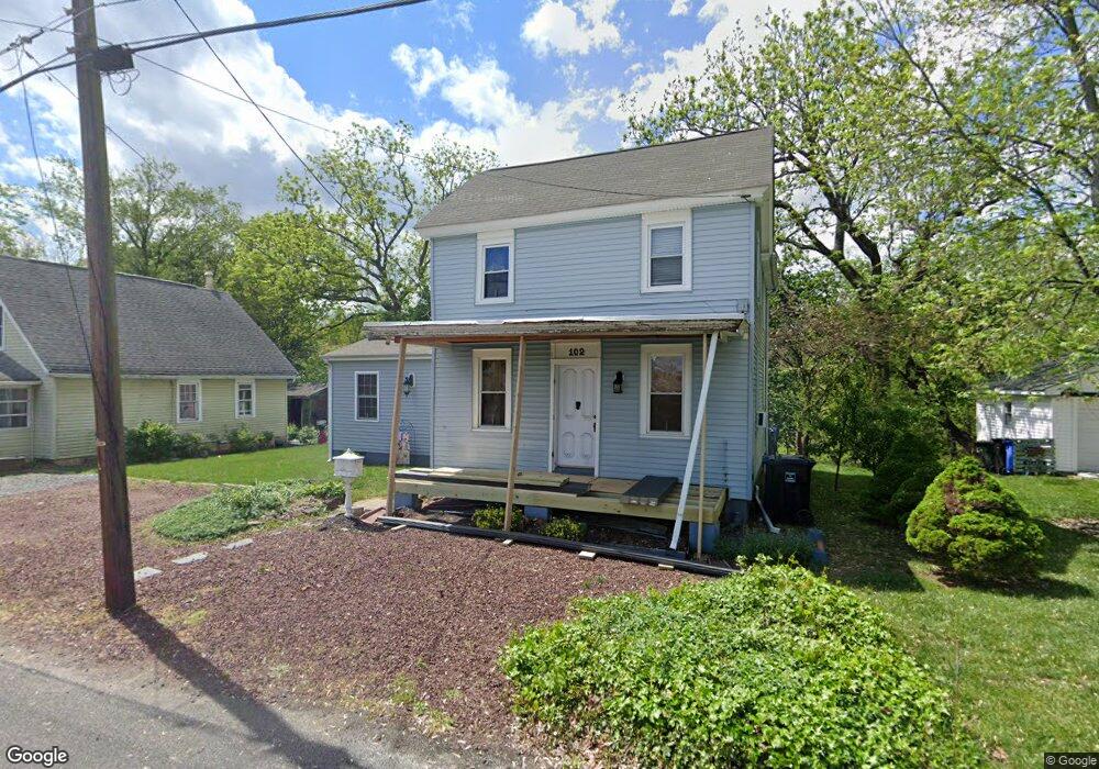
102 Hill St Mantua, NJ 08051
Mantua Township NeighborhoodEstimated Value: $284,000 - $377,000
--
Bed
--
Bath
1,779
Sq Ft
$191/Sq Ft
Est. Value
About This Home
This home is located at 102 Hill St, Mantua, NJ 08051 and is currently estimated at $339,175, approximately $190 per square foot. 102 Hill St is a home located in Gloucester County with nearby schools including Centre City School, Clearview Regional Middle School, and Clearview Regional High School.
Ownership History
Date
Name
Owned For
Owner Type
Purchase Details
Closed on
Feb 10, 1999
Sold by
Frenzel Charles
Bought by
Maronski Barbara and Mcdermott Kim
Current Estimated Value
Home Financials for this Owner
Home Financials are based on the most recent Mortgage that was taken out on this home.
Original Mortgage
$82,924
Outstanding Balance
$19,644
Interest Rate
6.75%
Mortgage Type
FHA
Estimated Equity
$319,531
Create a Home Valuation Report for This Property
The Home Valuation Report is an in-depth analysis detailing your home's value as well as a comparison with similar homes in the area
Home Values in the Area
Average Home Value in this Area
Purchase History
| Date | Buyer | Sale Price | Title Company |
|---|---|---|---|
| Maronski Barbara | $83,000 | Congress Title Corp |
Source: Public Records
Mortgage History
| Date | Status | Borrower | Loan Amount |
|---|---|---|---|
| Open | Maronski Barbara | $82,924 |
Source: Public Records
Tax History Compared to Growth
Tax History
| Year | Tax Paid | Tax Assessment Tax Assessment Total Assessment is a certain percentage of the fair market value that is determined by local assessors to be the total taxable value of land and additions on the property. | Land | Improvement |
|---|---|---|---|---|
| 2025 | $6,955 | $270,100 | $77,500 | $192,600 |
| 2024 | $6,882 | $270,100 | $77,500 | $192,600 |
| 2023 | $6,882 | $270,100 | $77,500 | $192,600 |
| 2022 | $6,108 | $174,600 | $67,500 | $107,100 |
| 2021 | $6,153 | $174,600 | $67,500 | $107,100 |
| 2020 | $6,087 | $174,100 | $67,500 | $106,600 |
| 2019 | $5,984 | $174,100 | $67,500 | $106,600 |
| 2018 | $5,899 | $174,100 | $67,500 | $106,600 |
| 2017 | $5,810 | $174,100 | $67,500 | $106,600 |
| 2016 | $5,744 | $174,100 | $67,500 | $106,600 |
| 2015 | $5,603 | $174,100 | $67,500 | $106,600 |
| 2014 | $5,415 | $174,100 | $67,500 | $106,600 |
Source: Public Records
Map
Nearby Homes
- 75 Hickory Ave
- 111 Cove Rd
- 1121 Tristram Cir Unit 1
- 1134 Tristram Cir Unit 4
- 1215 Tristram Cir
- 125 Ivy Ln
- 1145 Tristram Cir
- 1147 Tristram Cir Unit 1147
- 748 Dartmouth Dr
- 8 Barry Dr
- 1433 Tristram Cir
- 325 Bridgeton Pike
- 213 Barclay Ct
- 463 Durham Ct
- 205 Redbud Ln Unit 205
- 433 Berkley Rd
- 411 Durham Ct Unit 411
- 19 Marathon Dr
- 827 Saint Regis Ct
- 261 Tony Cir