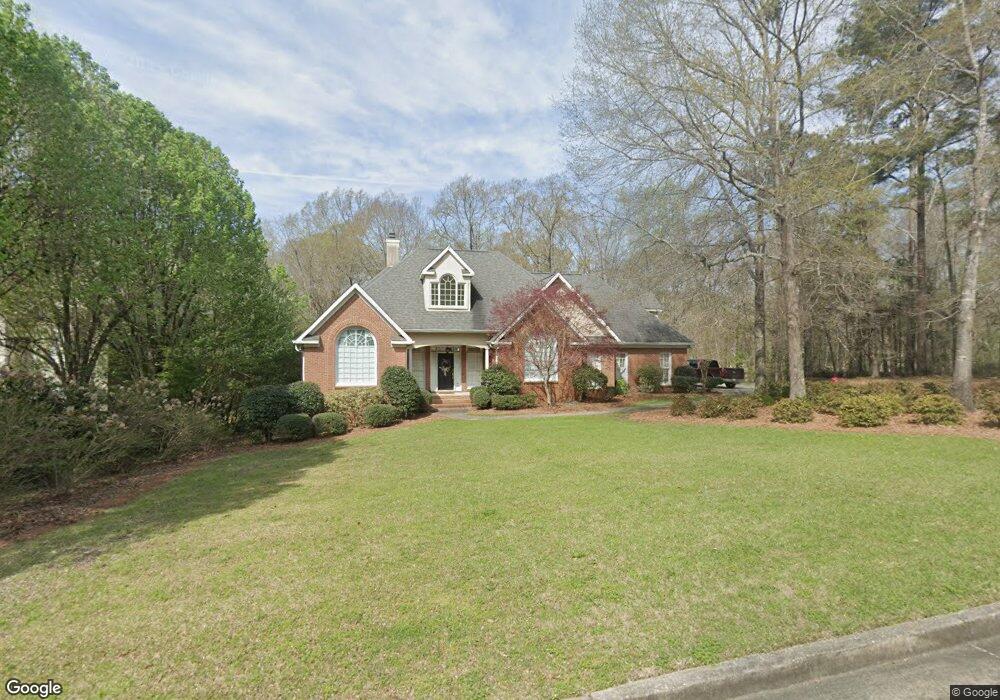
102 Kittansett Ct Macon, GA 31210
Estimated Value: $553,000 - $595,000
3
Beds
2
Baths
3,096
Sq Ft
$187/Sq Ft
Est. Value
About This Home
This home is located at 102 Kittansett Ct, Macon, GA 31210 and is currently estimated at $578,544, approximately $186 per square foot. 102 Kittansett Ct is a home located in Bibb County with nearby schools including Carter Elementary School, Howard Middle School, and Howard High School.
Ownership History
Date
Name
Owned For
Owner Type
Purchase Details
Closed on
Aug 30, 2005
Sold by
Giron Carlos J and Giron Mercedes G
Bought by
Kapoor Anita
Current Estimated Value
Home Financials for this Owner
Home Financials are based on the most recent Mortgage that was taken out on this home.
Original Mortgage
$276,000
Outstanding Balance
$144,540
Interest Rate
5.71%
Mortgage Type
New Conventional
Estimated Equity
$434,004
Create a Home Valuation Report for This Property
The Home Valuation Report is an in-depth analysis detailing your home's value as well as a comparison with similar homes in the area
Home Values in the Area
Average Home Value in this Area
Purchase History
| Date | Buyer | Sale Price | Title Company |
|---|---|---|---|
| Kapoor Anita | $345,000 | None Avilebel |
Source: Public Records
Mortgage History
| Date | Status | Borrower | Loan Amount |
|---|---|---|---|
| Open | Kapoor Anita | $276,000 |
Source: Public Records
Tax History Compared to Growth
Tax History
| Year | Tax Paid | Tax Assessment Tax Assessment Total Assessment is a certain percentage of the fair market value that is determined by local assessors to be the total taxable value of land and additions on the property. | Land | Improvement |
|---|---|---|---|---|
| 2025 | $4,689 | $197,805 | $59,760 | $138,045 |
| 2024 | $4,846 | $197,805 | $59,760 | $138,045 |
| 2023 | $4,084 | $185,801 | $59,760 | $126,041 |
| 2022 | $5,993 | $180,103 | $28,800 | $151,303 |
| 2021 | $6,195 | $170,016 | $28,800 | $141,216 |
| 2020 | $5,868 | $158,155 | $24,000 | $134,155 |
| 2019 | $5,404 | $145,042 | $24,000 | $121,042 |
| 2018 | $8,455 | $145,042 | $24,000 | $121,042 |
| 2017 | $4,934 | $138,701 | $24,000 | $114,701 |
| 2016 | $4,556 | $138,701 | $24,000 | $114,701 |
| 2015 | $6,450 | $138,701 | $24,000 | $114,701 |
| 2014 | $6,460 | $138,701 | $24,000 | $114,701 |
Source: Public Records
Map
Nearby Homes
- 117 Legare Ct
- 4532 Ayers Rd
- 776 Ivy Brook Way
- 740 Ivy Brook Way
- 715 Ivy Brook Way
- 534 Ivy Brook Way
- 1183 Saint Andrews Dr
- 621 Ivy Brook Way
- 631 Ivy Brook Way
- 4571 Shadow Lawn Dr
- 2006 Fall Harvest Dr Unit LOT 278
- 2006 Fall Harvest Dr
- 2002 Fall Harvest Dr
- 2008 Fall Harvest Dr Unit LOT 277
- 2004 Fall Harvest Dr
- 2010 Fall Harvest Dr Unit LOT 276
- 2010 Fall Harvest Dr
- 2002 Fall Harvest Dr Unit LOT 280
- 2008 Fall Harvest Dr
- 2004 Fall Harvest Dr Unit LOT 279
- 104 Kittansett Ct
- 103 Kittansett Ct
- 106 Kittansett Ct
- 950 Saint Andrews Dr
- 102 Turnberry Park
- 107 Kittansett Ct
- 103 Muirfield Rd
- 107 Muirfield Rd
- 104 Turnberry Park
- 109 Muirfield Rd
- 106 Turnberry Park
- 1071 Saint Andrews Dr
- 111 Muirfield Rd
- 1078 Saint Andrews Dr
- 4712 Moor Park
- 108 Muirfield Rd
- 110 Muirfield Rd
- 850 Saint Andrews Dr
- 106 Muirfield Rd
- 104 Muirfield Rd