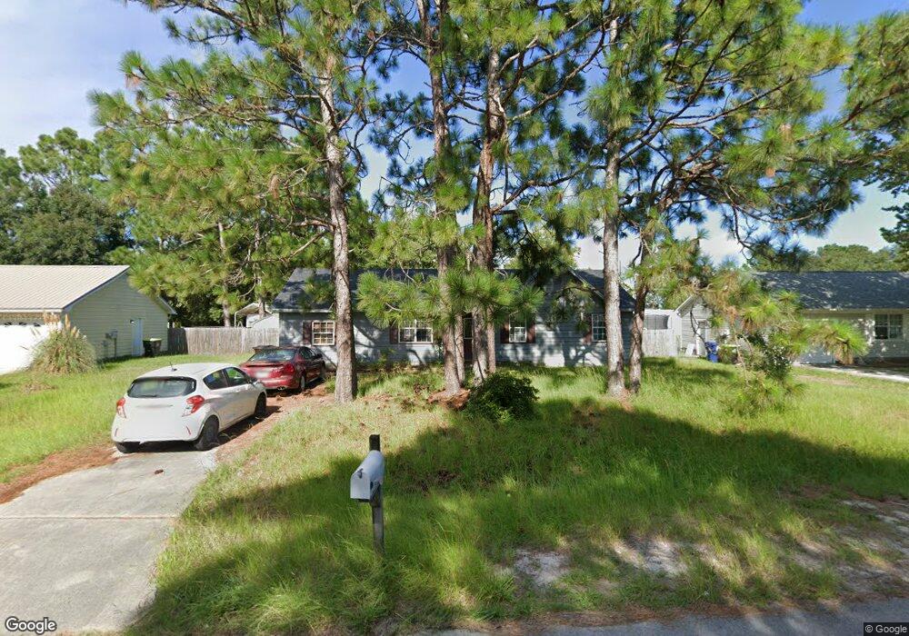
102 N Ginger Dr Hubert, NC 28539
Hubert NeighborhoodEstimated Value: $234,000 - $254,000
3
Beds
2
Baths
1,503
Sq Ft
$162/Sq Ft
Est. Value
About This Home
This home is located at 102 N Ginger Dr, Hubert, NC 28539 and is currently estimated at $242,910, approximately $161 per square foot. 102 N Ginger Dr is a home located in Onslow County with nearby schools including Sand Ridge Elementary School, Swansboro Middle School, and Swansboro High School.
Ownership History
Date
Name
Owned For
Owner Type
Purchase Details
Closed on
Jun 4, 2018
Sold by
Fickey Anton F and Fickey Carmen L
Bought by
Roth Robert L
Current Estimated Value
Home Financials for this Owner
Home Financials are based on the most recent Mortgage that was taken out on this home.
Original Mortgage
$12,000
Interest Rate
4.4%
Mortgage Type
Purchase Money Mortgage
Purchase Details
Closed on
Mar 17, 1997
Bought by
Fickey Anton F and Fickey Carmen L
Create a Home Valuation Report for This Property
The Home Valuation Report is an in-depth analysis detailing your home's value as well as a comparison with similar homes in the area
Home Values in the Area
Average Home Value in this Area
Purchase History
| Date | Buyer | Sale Price | Title Company |
|---|---|---|---|
| Roth Robert L | $112,000 | None Available | |
| Fickey Anton F | $58,300 | -- |
Source: Public Records
Mortgage History
| Date | Status | Borrower | Loan Amount |
|---|---|---|---|
| Closed | Roth Robert L | $12,000 |
Source: Public Records
Tax History
| Year | Tax Paid | Tax Assessment Tax Assessment Total Assessment is a certain percentage of the fair market value that is determined by local assessors to be the total taxable value of land and additions on the property. | Land | Improvement |
|---|---|---|---|---|
| 2025 | $1,006 | $153,526 | $40,000 | $113,526 |
| 2024 | $1,006 | $153,526 | $40,000 | $113,526 |
| 2023 | $1,006 | $153,526 | $40,000 | $113,526 |
| 2022 | $1,006 | $153,526 | $40,000 | $113,526 |
| 2021 | $795 | $112,740 | $30,000 | $82,740 |
| 2020 | $795 | $112,740 | $30,000 | $82,740 |
| 2019 | $795 | $112,740 | $30,000 | $82,740 |
| 2018 | $795 | $112,740 | $30,000 | $82,740 |
| 2017 | $792 | $117,280 | $30,000 | $87,280 |
| 2016 | $792 | $117,280 | $0 | $0 |
| 2015 | $792 | $117,280 | $0 | $0 |
| 2014 | $792 | $117,280 | $0 | $0 |
Source: Public Records
Map
Nearby Homes
- 104 Crown Point Rd
- 203 W Volant St
- 214 W Volant St
- 406 Foxtrace Ln
- 326 Sand Ridge Rd
- 316 Josie Ct
- 434 Oregon Trail
- 135 Rosemary Ave
- 142 Parnell Rd
- 127 Glenwood Dr
- 119 Sonia Dr
- 38 Riegel Dr
- 123 Sonia Dr
- 153 Glenwood Dr
- 206 Fox Way N
- 120 Sonia Dr
- 139 Pine Ct
- 103 Riegel Dr
- 205 Michel Ct
- 211 Lockwood Ct
- 104 N Ginger Dr
- 100 N Ginger Dr
- 106 N Ginger Dr
- 590 Sandridge Rd
- 103 N Ginger Dr
- 586 Sandridge Rd
- 592 Sandridge Rd
- 586 Sand Ridge Rd
- 201 S Ginger Dr
- 101 N Ginger Dr
- 582 Sandridge Rd
- 105 N Ginger Dr
- 107 N Ginger Dr
- 200 S Ginger Dr
- 598 Sandridge Rd
- 598 Sand Ridge Rd
- 109 N Ginger Dr
- 203 S Ginger Dr
- 202 S Ginger Dr
- 602 Sandridge Rd
Your Personal Tour Guide
Ask me questions while you tour the home.