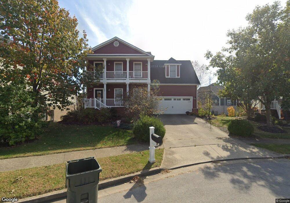
102 Rock Bridge Ct Georgetown, KY 40324
Northeast Georgetown NeighborhoodEstimated Value: $413,138 - $443,000
3
Beds
3
Baths
2,236
Sq Ft
$191/Sq Ft
Est. Value
About This Home
This home is located at 102 Rock Bridge Ct, Georgetown, KY 40324 and is currently estimated at $426,535, approximately $190 per square foot. 102 Rock Bridge Ct is a home located in Scott County with nearby schools including Anne Mason Elementary School, Scott County Middle School, and Scott County High School.
Ownership History
Date
Name
Owned For
Owner Type
Purchase Details
Closed on
Apr 29, 2020
Sold by
Sandbnnk Steven Michael and Sandbnnk Allison
Bought by
Rebholz Brittany and Rebholz Michael
Current Estimated Value
Home Financials for this Owner
Home Financials are based on the most recent Mortgage that was taken out on this home.
Original Mortgage
$303,905
Outstanding Balance
$268,512
Interest Rate
3.6%
Mortgage Type
New Conventional
Estimated Equity
$158,023
Create a Home Valuation Report for This Property
The Home Valuation Report is an in-depth analysis detailing your home's value as well as a comparison with similar homes in the area
Home Values in the Area
Average Home Value in this Area
Purchase History
| Date | Buyer | Sale Price | Title Company |
|---|---|---|---|
| Rebholz Brittany | $319,900 | Bluegrass Land Title Llc |
Source: Public Records
Mortgage History
| Date | Status | Borrower | Loan Amount |
|---|---|---|---|
| Open | Rebholz Brittany | $303,905 |
Source: Public Records
Tax History
| Year | Tax Paid | Tax Assessment Tax Assessment Total Assessment is a certain percentage of the fair market value that is determined by local assessors to be the total taxable value of land and additions on the property. | Land | Improvement |
|---|---|---|---|---|
| 2025 | $3,311 | $371,700 | $0 | $0 |
| 2024 | $3,032 | $337,100 | $0 | $0 |
| 2023 | $2,935 | $323,700 | $50,000 | $273,700 |
| 2022 | $2,720 | $319,900 | $50,000 | $269,900 |
| 2021 | $3,013 | $319,900 | $50,000 | $269,900 |
| 2020 | $2,590 | $301,400 | $50,000 | $251,400 |
| 2019 | $2,356 | $269,900 | $0 | $0 |
| 2018 | $2,342 | $269,900 | $0 | $0 |
| 2017 | $2,354 | $269,900 | $0 | $0 |
| 2016 | $2,173 | $269,900 | $0 | $0 |
| 2015 | $2,159 | $269,900 | $0 | $0 |
| 2014 | $2,244 | $270,700 | $0 | $0 |
| 2011 | $161 | $260,400 | $0 | $0 |
Source: Public Records
Map
Nearby Homes
- 106 Rockbridge Ct
- 107 Rockbridge Ct
- 102 Creekstone Ct
- 179 Village Park Dr
- 127 Charleston Cir
- 123 Charleston Cir
- 26 Waterson Park Dr
- 163 Village Park Dr
- 121 Charleston Cir
- 149 Blackberry Ln
- 120 Falls Creek Dr
- 118 Falls Creek Dr
- 100 Woods Point Cir
- 116 Falls Creek Dr
- 125 Blackberry Ln
- 123 Blackberry Ln
- 151 Village Park Dr
- 136 Blackberry Ln
- 113 Blackberry Ln
- 109 Blackberry Ln
- 102 Rockbridge Ct
- 100 Rockbridge Ct
- 100 Rock Bridge Ct
- 104 Rockbridge Ct
- 104 Rock Bridge Ct
- 103 Creekstone Ct
- 105 Creekstone Ct
- 101 Creekstone Ct
- 106 Rock Bridge Ct
- 106 Creekstone Ct
- 101 Rockbridge Ct
- 107 Creekstone Ct
- 103 Rockbridge Ct
- 144 Arbor Grove Cir
- 105 Rockbridge Ct
- 101 Rock Bridge Ct
- 103 Rock Bridge Ct Unit 1
- 156 Falls Creek Dr
- 107 Rock Bridge Ct
- 140 Falls Creek Dr