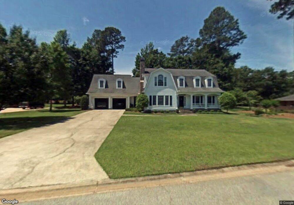
102 Sandtrap Way Warner Robins, GA 31088
Estimated Value: $387,000 - $446,000
Studio
--
Bath
3,339
Sq Ft
$124/Sq Ft
Est. Value
About This Home
This home is located at 102 Sandtrap Way, Warner Robins, GA 31088 and is currently estimated at $413,030, approximately $123 per square foot. 102 Sandtrap Way is a home located in Houston County with nearby schools including Bonaire Elementary School, Huntington Middle School, and Warner Robins High School.
Ownership History
Date
Name
Owned For
Owner Type
Purchase Details
Closed on
Jan 6, 1990
Sold by
Smith George M
Bought by
Smith George M and Marian Frances L*
Current Estimated Value
Purchase Details
Closed on
Jan 5, 1990
Sold by
Smith George M and Frances L*
Bought by
Smith George M
Purchase Details
Closed on
Feb 11, 1988
Sold by
Stathams Landing Co
Bought by
Smith George M and Frances L*
Create a Home Valuation Report for This Property
The Home Valuation Report is an in-depth analysis detailing your home's value as well as a comparison with similar homes in the area
Home Values in the Area
Average Home Value in this Area
Purchase History
| Date | Buyer | Sale Price | Title Company |
|---|---|---|---|
| Smith George M | -- | -- | |
| Smith George M | -- | -- | |
| Smith George M | $23,500 | -- |
Source: Public Records
Tax History
| Year | Tax Paid | Tax Assessment Tax Assessment Total Assessment is a certain percentage of the fair market value that is determined by local assessors to be the total taxable value of land and additions on the property. | Land | Improvement |
|---|---|---|---|---|
| 2025 | $3,282 | $154,760 | $16,000 | $138,760 |
| 2024 | $3,524 | $149,320 | $16,000 | $133,320 |
| 2023 | $2,907 | $122,280 | $16,000 | $106,280 |
| 2022 | $2,641 | $111,280 | $16,000 | $95,280 |
| 2021 | $2,427 | $101,880 | $16,000 | $85,880 |
| 2020 | $2,296 | $93,840 | $16,000 | $77,840 |
| 2019 | $2,242 | $93,840 | $16,000 | $77,840 |
| 2018 | $2,242 | $93,840 | $16,000 | $77,840 |
| 2017 | $2,244 | $93,840 | $16,000 | $77,840 |
| 2016 | $2,247 | $93,840 | $16,000 | $77,840 |
| 2015 | $2,252 | $93,840 | $16,000 | $77,840 |
| 2014 | -- | $95,280 | $16,000 | $79,280 |
| 2013 | -- | $95,280 | $16,000 | $79,280 |
Source: Public Records
Map
Nearby Homes
- 125 Bunkers Trail
- 108 Bunkers Trail
- 104 Bunkers Trail
- 108 Falcon Crest
- 215 Falcon Crest
- 256 Falcon Crest Unit STATHAMS LANDING
- 215 Falcon Crest Unit Stathams Landing
- 256 Falcon Crest
- 201 Stathams Way
- 109 Crest Pointe
- 100 Club Place Ct
- 106 Club Ct
- 212 Falcon Crest
- 114 Hampton Pointe
- 107 Deerwood Dr
- 226 Landings Pointe Ln
- 602 Charlestown Way
- 601 Charlestown Way
- 115 Saint Augustine Dr
- 105 Sandy Pointe Dr
- 104 Sandtrap Way
- 104 Sand Trap Way
- 116 Bunkers Trail
- 103 Wedge Way
- 101 Sandtrap Way
- 114 Bunkers Trail
- 101 Sand Trap Way
- 105 Wedge Way
- 106 Sand Trap Way
- 106 Sandtrap Way
- 103 Sandtrap Way
- 128 Bunkers Trail
- 105 Sandtrap Way
- 117 Bunkers Trail
- 119 Bunkers Trail
- 106 Wedge Way
- 115 Bunkers Trail
- 102 Wedge Way
- 121 Bunkers Trail
- 110 Bunkers Trail
Your Personal Tour Guide
Ask me questions while you tour the home.