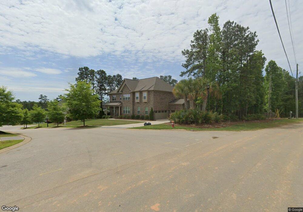
102 Sunset Ridge Ln Chapin, SC 29036
Estimated Value: $741,000 - $789,000
5
Beds
4
Baths
4,425
Sq Ft
$173/Sq Ft
Est. Value
About This Home
This home is located at 102 Sunset Ridge Ln, Chapin, SC 29036 and is currently estimated at $763,360, approximately $172 per square foot. 102 Sunset Ridge Ln is a home located in Lexington County with nearby schools including Lake Murray Elementary School, Chapin Intermediate, and Chapin High School.
Ownership History
Date
Name
Owned For
Owner Type
Purchase Details
Closed on
May 14, 2020
Sold by
Koehler Lauren Emily and Koehler Anthony Joseph
Bought by
Roach Andrew Kennedy and Roach Susan Maxwell
Current Estimated Value
Home Financials for this Owner
Home Financials are based on the most recent Mortgage that was taken out on this home.
Original Mortgage
$484,900
Outstanding Balance
$450,853
Interest Rate
3.3%
Mortgage Type
New Conventional
Estimated Equity
$312,507
Purchase Details
Closed on
Jun 30, 2017
Sold by
Koehler Anthony Joseph
Bought by
Koehler Anthony Joseph and Koehler Lauren Emily
Home Financials for this Owner
Home Financials are based on the most recent Mortgage that was taken out on this home.
Original Mortgage
$400,000
Interest Rate
3.75%
Mortgage Type
Adjustable Rate Mortgage/ARM
Create a Home Valuation Report for This Property
The Home Valuation Report is an in-depth analysis detailing your home's value as well as a comparison with similar homes in the area
Home Values in the Area
Average Home Value in this Area
Purchase History
| Date | Buyer | Sale Price | Title Company |
|---|---|---|---|
| Roach Andrew Kennedy | $574,900 | None Available | |
| Koehler Anthony Joseph | -- | None Available | |
| Koehler Anthony Joseph | $500,000 | None Available |
Source: Public Records
Mortgage History
| Date | Status | Borrower | Loan Amount |
|---|---|---|---|
| Open | Roach Andrew Kennedy | $484,900 | |
| Previous Owner | Koehler Anthony Joseph | $400,000 |
Source: Public Records
Tax History Compared to Growth
Tax History
| Year | Tax Paid | Tax Assessment Tax Assessment Total Assessment is a certain percentage of the fair market value that is determined by local assessors to be the total taxable value of land and additions on the property. | Land | Improvement |
|---|---|---|---|---|
| 2024 | $3,789 | $22,996 | $2,400 | $20,596 |
| 2023 | $3,489 | $22,996 | $2,400 | $20,596 |
| 2020 | $3,490 | $21,590 | $2,400 | $19,190 |
| 2019 | $3,289 | $20,000 | $2,000 | $18,000 |
| 2018 | $2,895 | $20,000 | $2,000 | $18,000 |
| 2017 | $2,249 | $15,954 | $2,000 | $13,954 |
| 2016 | $9,735 | $23,931 | $3,000 | $20,931 |
Source: Public Records
Map
Nearby Homes
- 417 Brookridge Dr
- 1081 Point View Rd
- 1118 Marble Arch Ct
- 450 Brookridge Dr Unit LOT 55
- 454 Brookridge Dr
- 516 Mitscher Way
- 533 Mitscher Way
- 143 Doolittle Dr
- 2124 Ludlow Place
- 2130 Ludlow Place
- 2347 Hadley Crossing
- 2351 Hadley Crossing
- 2355 Hadley Crossing
- 3031 Chilmark Rd
- 2348 Hadley Crossing
- 2344 Hadley Crossing
- 313 Mallard Dr
- 3010 Chilmark Rd
- 515 Pine Log Run
- 306 Rising Stream Way
- 241 Brookridge Dr
- 245 Brookridge Dr
- 109 Sunsation Dr
- 103 Sunset Ridge Ln
- 237 Brookridge Dr
- 255 Brookridge Dr
- 206 Brookridge Dr
- 242 Brookridge Dr
- 233 Brookridge Dr
- 304 Quail Walk Trail
- 254 Brookridge Dr
- 265 Brookridge Dr
- 238 Brookridge Dr
- 234 Brookridge Dr
- 271 Brookridge Dr
- 307 Brookridge Dr
- 258 Brookridge Dr
- 229 Brookridge Dr
- 262 Brookridge Dr
- 0 Brookridge Dr Unit 215006