Estimated Value: $53,000 - $97,000
5
Beds
2
Baths
2,102
Sq Ft
$31/Sq Ft
Est. Value
About This Home
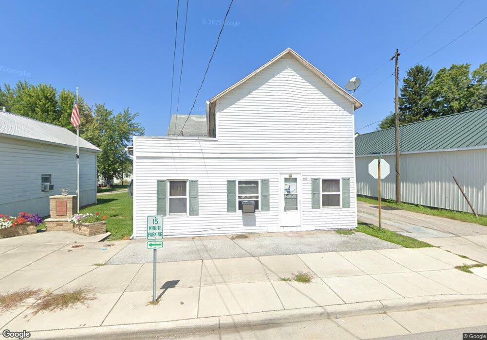
This home is located at 102 W Main St, Cairo, OH 45820 and is currently estimated at $65,566, approximately $31 per square foot. 102 W Main St is a home located in Allen County with nearby schools including Bath Elementary School, Bath Middle School, and Bath High School.
Ownership History
Date
Name
Owned For
Owner Type
Purchase Details
Closed on
Jun 23, 2025
Sold by
Meredith Thomas L and Meredith Tom
Bought by
Gearing Blaine and Gearing Michelle
Current Estimated Value
Purchase Details
Closed on
Aug 26, 2020
Sold by
Meredith Thomas and Meredith Carol
Bought by
Meredith Thomas and Meredith Carol
Purchase Details
Closed on
Dec 4, 2001
Sold by
Pocza James W
Bought by
Meredith Thomas and Meredith Carol
Purchase Details
Closed on
Mar 7, 1991
Bought by
Foltz Norman E
Create a Home Valuation Report for This Property
The Home Valuation Report is an in-depth analysis detailing your home's value as well as a comparison with similar homes in the area
Home Values in the Area
Average Home Value in this Area
Purchase History
| Date | Buyer | Sale Price | Title Company |
|---|---|---|---|
| Gearing Blaine | $55,000 | None Listed On Document | |
| Meredith Thomas | -- | None Available | |
| Meredith Thomas | $27,000 | -- | |
| Foltz Norman E | -- | -- |
Source: Public Records
Tax History Compared to Growth
Tax History
| Year | Tax Paid | Tax Assessment Tax Assessment Total Assessment is a certain percentage of the fair market value that is determined by local assessors to be the total taxable value of land and additions on the property. | Land | Improvement |
|---|---|---|---|---|
| 2024 | $1,226 | $28,570 | $1,650 | $26,920 |
| 2023 | $628 | $10,190 | $1,400 | $8,790 |
| 2022 | $626 | $10,190 | $1,400 | $8,790 |
| 2021 | $618 | $10,190 | $1,400 | $8,790 |
| 2020 | $638 | $9,940 | $3,080 | $6,860 |
| 2019 | $638 | $9,940 | $3,080 | $6,860 |
| 2018 | $623 | $9,940 | $3,080 | $6,860 |
| 2017 | $621 | $9,940 | $3,080 | $6,860 |
| 2016 | $612 | $9,940 | $3,080 | $6,860 |
| 2015 | $611 | $9,940 | $3,080 | $6,860 |
| 2014 | $618 | $10,050 | $3,400 | $6,650 |
| 2013 | $619 | $10,050 | $3,400 | $6,650 |
Source: Public Records
Map
Nearby Homes
- 201 Wall St
- 309 Wall St
- 220 Parklane Dr
- 300 Sweaney Ave
- 6585 Ottawa Rd
- 3456 Shearin Ave
- 3798 Kissing Hollow Dr
- 3270 Bonnieview Dr
- 4080 Brookshore Dr
- 4050 Brookshore Dr
- 1679 E Bluelick Rd
- 108 Highland Lakes Dr
- 0 Fraunfelter Unit 307817
- 0 N Eastown Rd Unit 1034495
- 2525 W Lincoln Hwy
- 2467 Greendale St
- 1129 W Bluelick Rd
- 4619 N Thayer Rd
- 0 N Dixie Hwy Unit 308796
- 0 N Dixie Hwy Unit 300253