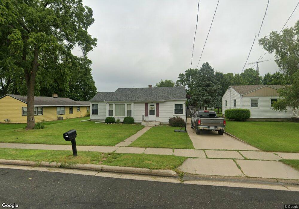
102 William St Watertown, WI 53094
Estimated Value: $207,495 - $249,000
--
Bed
--
Bath
--
Sq Ft
0.25
Acres
About This Home
This home is located at 102 William St, Watertown, WI 53094 and is currently estimated at $225,124. 102 William St is a home located in Jefferson County with nearby schools including Watertown High School, eCampus Academy Charter School, and Trinity-St. Luke's Lutheran Elementary School.
Ownership History
Date
Name
Owned For
Owner Type
Purchase Details
Closed on
Dec 6, 2013
Sold by
Bank Of Lake Mills
Bought by
Kuehl Craig D and Kuehl Brenda S
Current Estimated Value
Home Financials for this Owner
Home Financials are based on the most recent Mortgage that was taken out on this home.
Original Mortgage
$48,750
Outstanding Balance
$36,113
Interest Rate
4.14%
Mortgage Type
New Conventional
Estimated Equity
$189,011
Purchase Details
Closed on
Nov 18, 2013
Sold by
Frasser Richard L
Bought by
Bank Of Lake Mills
Home Financials for this Owner
Home Financials are based on the most recent Mortgage that was taken out on this home.
Original Mortgage
$48,750
Outstanding Balance
$36,113
Interest Rate
4.14%
Mortgage Type
New Conventional
Estimated Equity
$189,011
Purchase Details
Closed on
Aug 9, 2007
Sold by
Braun Theresa M
Bought by
Frasser Richard L
Create a Home Valuation Report for This Property
The Home Valuation Report is an in-depth analysis detailing your home's value as well as a comparison with similar homes in the area
Home Values in the Area
Average Home Value in this Area
Purchase History
| Date | Buyer | Sale Price | Title Company |
|---|---|---|---|
| Kuehl Craig D | $65,000 | None Available | |
| Bank Of Lake Mills | $65,000 | -- | |
| Frasser Richard L | $115,000 | None Available |
Source: Public Records
Mortgage History
| Date | Status | Borrower | Loan Amount |
|---|---|---|---|
| Open | Kuehl Craig D | $48,750 |
Source: Public Records
Tax History Compared to Growth
Tax History
| Year | Tax Paid | Tax Assessment Tax Assessment Total Assessment is a certain percentage of the fair market value that is determined by local assessors to be the total taxable value of land and additions on the property. | Land | Improvement |
|---|---|---|---|---|
| 2024 | $2,587 | $174,900 | $51,400 | $123,500 |
| 2023 | $2,553 | $145,200 | $45,400 | $99,800 |
| 2022 | $2,563 | $145,200 | $45,400 | $99,800 |
| 2021 | $2,117 | $84,000 | $26,000 | $58,000 |
| 2020 | $2,215 | $84,000 | $26,000 | $58,000 |
| 2019 | $2,044 | $84,000 | $26,000 | $58,000 |
| 2018 | $1,988 | $84,000 | $26,000 | $58,000 |
| 2017 | $1,888 | $84,000 | $26,000 | $58,000 |
| 2016 | $1,865 | $84,000 | $26,000 | $58,000 |
| 2015 | $1,842 | $84,000 | $26,000 | $58,000 |
| 2014 | $1,867 | $84,000 | $26,000 | $58,000 |
| 2013 | $3,199 | $84,000 | $26,000 | $58,000 |
Source: Public Records
Map
Nearby Homes
- 1215 Utah St
- 1313 Utah St
- 1314 Waldron St
- 131 Cedar Ct
- The Saybrook Plan at Rock River Ridge
- The Atwater Plan at Rock River Ridge
- The Hudson Plan at Rock River Ridge
- The Coral Plan at Rock River Ridge
- The Drake Plan at Rock River Ridge
- The Addison Plan at Rock River Ridge
- The Bradford Plan at Rock River Ridge
- The Catalina Plan at Rock River Ridge
- The Adrian Plan at Rock River Ridge
- The McKinley Plan at Rock River Ridge
- The Siena Plan at Rock River Ridge
- The Bridgeport Plan at Rock River Ridge
- The Wingra Plan at Rock River Ridge
- The Conway Plan at Rock River Ridge
- The Dover Plan at Rock River Ridge
- The Charleston Plan at Rock River Ridge