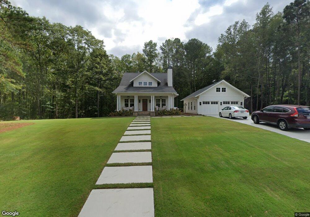
1020 Bell Rd Bremen, GA 30110
Estimated Value: $403,000 - $520,630
2
Beds
2
Baths
1,482
Sq Ft
$307/Sq Ft
Est. Value
About This Home
This home is located at 1020 Bell Rd, Bremen, GA 30110 and is currently estimated at $455,210, approximately $307 per square foot. 1020 Bell Rd is a home with nearby schools including Mt. Zion Elementary School, Mt. Zion Middle School, and Mt. Zion High School.
Ownership History
Date
Name
Owned For
Owner Type
Purchase Details
Closed on
May 27, 2016
Sold by
Martin Lewis Glenn
Bought by
Shaw James Curt and Shaw Nicole
Current Estimated Value
Purchase Details
Closed on
Dec 21, 2005
Sold by
Bell Larry
Bought by
Martin Lewis G and Martin Leann H
Purchase Details
Closed on
Nov 2, 2004
Sold by
Bell Larry
Bought by
Butler Richard K and Frazier William
Purchase Details
Closed on
Dec 31, 1999
Sold by
Bell Bobby and Bell Tommy
Bought by
Bell Larry
Create a Home Valuation Report for This Property
The Home Valuation Report is an in-depth analysis detailing your home's value as well as a comparison with similar homes in the area
Home Values in the Area
Average Home Value in this Area
Purchase History
| Date | Buyer | Sale Price | Title Company |
|---|---|---|---|
| Shaw James Curt | $37,500 | -- | |
| Martin Lewis G | $35,000 | -- | |
| Butler Richard K | -- | -- | |
| Bell Larry | -- | -- |
Source: Public Records
Tax History
| Year | Tax Paid | Tax Assessment Tax Assessment Total Assessment is a certain percentage of the fair market value that is determined by local assessors to be the total taxable value of land and additions on the property. | Land | Improvement |
|---|---|---|---|---|
| 2025 | $3,897 | $178,198 | $34,658 | $143,540 |
| 2024 | $4,031 | $178,198 | $34,658 | $143,540 |
| 2023 | $4,031 | $159,585 | $27,726 | $131,859 |
| 2022 | $2,170 | $86,543 | $18,484 | $68,059 |
| 2021 | $1,490 | $58,134 | $14,788 | $43,346 |
| 2020 | $1,007 | $39,219 | $13,443 | $25,776 |
| 2019 | $348 | $13,443 | $13,443 | $0 |
| 2018 | $132 | $5,031 | $5,031 | $0 |
| 2017 | $133 | $5,031 | $5,031 | $0 |
| 2016 | $133 | $5,031 | $5,031 | $0 |
| 2015 | $365 | $13,059 | $13,060 | $0 |
| 2014 | -- | $13,060 | $13,060 | $0 |
Source: Public Records
Map
Nearby Homes
- 0 Bell Rd Unit 7734894
- 0 Bell Rd Unit 10710459
- 2410 Mandeville Rd
- 1800 Mandeville Rd
- 602 Mandeville Rd
- 592 Whittman Ct
- 504 J C Daniel Rd
- 0000 Hog Liver Rd
- 391 Hog Liver Rd
- 1577 Georgia Ave S
- 126 Covered Bridge Rd
- 112 Summit Ln
- 1401 Alabama Ave
- 125 Bethlehem Church Rd
- 0 Bethlehem Church Rd Unit 7719552
- 0 Bethlehem Church Rd Unit 10691788
- 338 Springwater Way
- 354 Springwater Way
- 405 Adler Point
- 00 Hog Liver Rd Unit 346
- 0 Bell Rd Unit 3247898
- 0 Bell Rd Unit 7226943
- 992 Bell Rd
- 1052 Bell Rd
- 1001 Bell Rd
- 1068 Bell Rd
- 1071 Bell Rd
- 1240 Mandeville Rd
- 1250 Mandeville Rd
- 5 Walnut Hill Rd
- 1260 Mandeville Rd
- 80 Parks Rd
- 1097 Bell Rd
- 9 Walnut Hill Rd
- 0 Bell Rd Unit 20138469
- 0 Bell Rd Unit 10117149
- 0 Bell Rd Unit 7024753
- 0 Bell Rd Unit 10033770
- 1140 Mandeville Rd
- 0 Mandeville Rd Unit 20058265
Your Personal Tour Guide
Ask me questions while you tour the home.