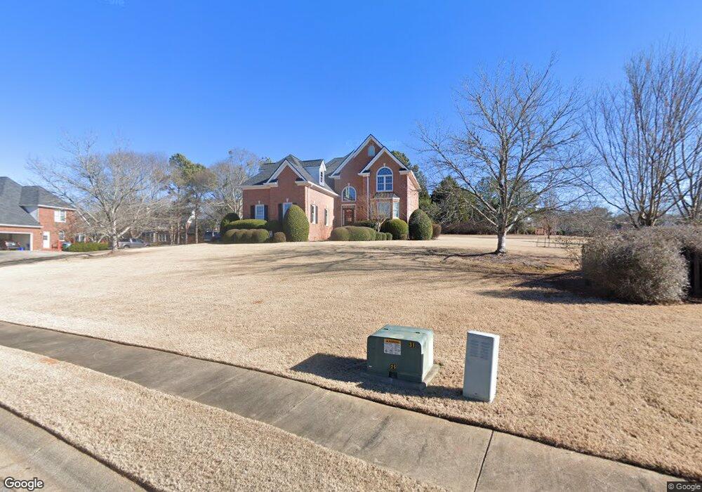
1020 Buckeye Point Athens, GA 30606
Estimated Value: $664,000 - $800,000
4
Beds
4
Baths
3,148
Sq Ft
$233/Sq Ft
Est. Value
About This Home
This home is located at 1020 Buckeye Point, Athens, GA 30606 and is currently estimated at $734,667, approximately $233 per square foot. 1020 Buckeye Point is a home located in Oconee County with nearby schools including Oconee County Elementary School, Oconee County Primary School, and Oconee County Middle School.
Ownership History
Date
Name
Owned For
Owner Type
Purchase Details
Closed on
Sep 23, 2008
Sold by
Not Provided
Bought by
English Jeffrey K
Current Estimated Value
Purchase Details
Closed on
May 7, 2001
Sold by
Lane Lane and Lane Marbut
Bought by
English Jeffrey K and English Laura W
Purchase Details
Closed on
Dec 4, 2000
Sold by
Lane Brinson
Bought by
Lane Lane and Lane Marbut
Purchase Details
Closed on
Dec 4, 1997
Sold by
Lake Wellbrook Llc
Bought by
Lane Brinson
Create a Home Valuation Report for This Property
The Home Valuation Report is an in-depth analysis detailing your home's value as well as a comparison with similar homes in the area
Purchase History
| Date | Buyer | Sale Price | Title Company |
|---|---|---|---|
| English Jeffrey K | -- | -- | |
| English Jeffrey K | $280,000 | -- | |
| Lane Lane | $235,800 | -- | |
| Lane Brinson | $38,000 | -- |
Source: Public Records
Tax History
| Year | Tax Paid | Tax Assessment Tax Assessment Total Assessment is a certain percentage of the fair market value that is determined by local assessors to be the total taxable value of land and additions on the property. | Land | Improvement |
|---|---|---|---|---|
| 2025 | $3,874 | $218,626 | $34,000 | $184,626 |
| 2024 | $4,174 | $210,981 | $34,500 | $176,481 |
| 2023 | $4,318 | $201,815 | $34,000 | $167,815 |
| 2022 | $3,868 | $180,868 | $34,000 | $146,868 |
| 2021 | $3,716 | $161,162 | $34,000 | $127,162 |
| 2020 | $3,652 | $158,166 | $38,000 | $120,166 |
| 2019 | $3,515 | $152,262 | $38,000 | $114,262 |
| 2018 | $3,524 | $149,461 | $38,000 | $111,461 |
| 2017 | $3,429 | $145,474 | $38,000 | $107,474 |
Source: Public Records
Map
Nearby Homes
- 1090 Scarlet Oak Cir
- 1270 Nona Dr
- 2481 Lakewood Manor Dr
- 2041 Lakewood Manor Dr
- 1141 Beverly Dr
- 1271 Daniells Bridge Rd
- 1611 Crystal Hills Dr
- 1340 Old Epps Bridge Rd
- 1542 Meadow Springs Dr
- 8471 Macon Hwy
- 2950 Stone Rd
- 1051 Spartan Ln
- 1609 Meadow Lakes Dr
- 1091 Barber Creek Dr
- 1140 Tuxedo Ln
- 381 Township Ln
- 1500 Bouldercrest Cir
- 1531 Bouldercrest Cir
- 155 Ridgeview Dr
- 8660 Macon Hwy
- 1020 Buckeye Pointe
- 1030 Buckeye Pointe
- 1210 Willow Ridge
- 1420 Lake Welbrook Dr
- 1420 Lake Wellbrook Dr
- 1190 Willow Ridge
- 1400 Lake Welbrook Dr
- 1440 Lake Welbrook Dr
- -- Willow Ridge
- 1041 Buckeye Pointe
- 1220 Willow Ridge
- 1040 Buckeye Pointe
- 1170 Willow Ridge
- 1240 Willow Ridge
- 1380 Lake Welbrook Dr
- 1380 Lake Wellbrook Dr
- 1181 Willow Ridge
- 1460 Lake Welbrook Dr
- 1211 Willow Ridge
- 1051 Buckeye Pointe
Your Personal Tour Guide
Ask me questions while you tour the home.