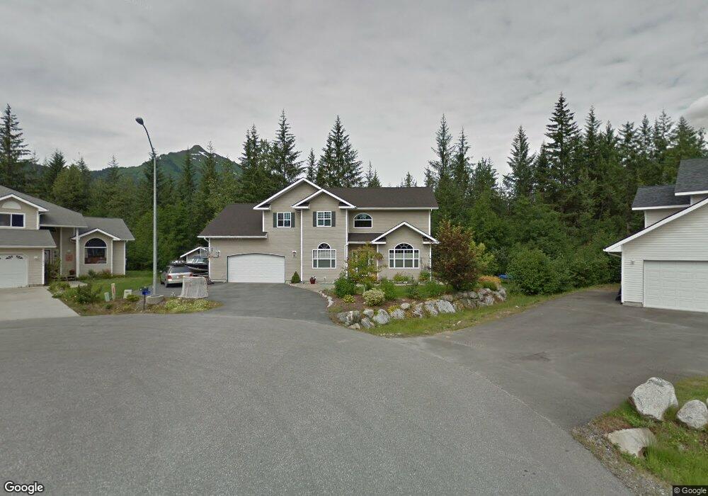
1020 Debbie Ln Juneau, AK 99801
Back Loop NeighborhoodEstimated Value: $229,000 - $817,608
4
Beds
3
Baths
2,923
Sq Ft
$219/Sq Ft
Est. Value
About This Home
This home is located at 1020 Debbie Ln, Juneau, AK 99801 and is currently estimated at $638,902, approximately $218 per square foot. 1020 Debbie Ln is a home located in Juneau City and Borough with nearby schools including Auke Bay Elementary School.
Ownership History
Date
Name
Owned For
Owner Type
Purchase Details
Closed on
Aug 14, 2003
Sold by
Montana Creek Development Inc
Bought by
Ainsworth Thomas P and Ainsworth Suzanne M
Current Estimated Value
Home Financials for this Owner
Home Financials are based on the most recent Mortgage that was taken out on this home.
Original Mortgage
$300,000
Outstanding Balance
$128,929
Interest Rate
5.29%
Mortgage Type
Purchase Money Mortgage
Estimated Equity
$509,973
Create a Home Valuation Report for This Property
The Home Valuation Report is an in-depth analysis detailing your home's value as well as a comparison with similar homes in the area
Home Values in the Area
Average Home Value in this Area
Purchase History
| Date | Buyer | Sale Price | Title Company |
|---|---|---|---|
| Ainsworth Thomas P | -- | Title Insurance Agency |
Source: Public Records
Mortgage History
| Date | Status | Borrower | Loan Amount |
|---|---|---|---|
| Open | Ainsworth Thomas P | $300,000 |
Source: Public Records
Tax History Compared to Growth
Tax History
| Year | Tax Paid | Tax Assessment Tax Assessment Total Assessment is a certain percentage of the fair market value that is determined by local assessors to be the total taxable value of land and additions on the property. | Land | Improvement |
|---|---|---|---|---|
| 2025 | $7,685 | $750,500 | $165,300 | $585,200 |
| 2024 | $7,870 | $783,900 | $165,300 | $618,600 |
| 2023 | $7,819 | $769,600 | $165,300 | $604,300 |
| 2022 | $6,723 | $636,600 | $159,100 | $477,500 |
| 2021 | $6,231 | $590,100 | $159,100 | $431,000 |
| 2020 | $6,103 | $572,500 | $159,100 | $413,400 |
| 2019 | $5,951 | $558,300 | $159,100 | $399,200 |
| 2018 | $6,176 | $563,900 | $167,700 | $396,200 |
| 2017 | $6,176 | $585,190 | $176,916 | $408,274 |
| 2016 | $6,176 | $579,396 | $175,164 | $404,232 |
| 2015 | -- | $546,600 | $165,249 | $381,351 |
| 2014 | -- | $542,800 | $164,100 | $378,700 |
Source: Public Records
Map
Nearby Homes
- 5030 Pond Vista Dr
- 1013 Arctic Cir
- 9852 Lone Wolf Dr
- 9990 Mendenhall Loop Rd
- 4920 Steelhead St
- 4401 Riverside Dr Unit B4
- 4401 Riverside Dr Unit E3
- 4401 Riverside Dr Unit H1
- 4409 Mint Way
- 4404 Cloverdale St
- 4521 Wood Duck Ave
- 4416 Mint Way
- 4494 Chelsea Ct
- 4374 Taku Blvd
- 4403 Taku Blvd
- 4353 Taku Blvd
- 4242 N Riverside Dr
- 4425 Julep St
- 4195 Taku Blvd
- 4409 Julep St
- 1024 Debbie Ln
- 1016 Debbie Ln
- 1008 Debbie Ln
- 9136 Black Wolf Way
- 1000 Debbie Ln
- 5000 Pond Vista Dr
- 9144 Black Wolf Way
- 9196 Wolfram Way
- 9100 Black Wolf Way
- 9188 Wolfram Way
- 5001 Pond Vista Dr
- 5006 Pond Vista Dr
- 1030 Arctic Cir
- 9097 Black Wolf Way
- 9152 Black Wolf Way
- 9180 Wolfram Way
- 9155 Black Wolf Way
- 9191 Wolfram Way
- 5007 Pond Vista Dr
- 9089 Ninnis Dr