Estimated Value: $286,000 - $296,000
6
Beds
6
Baths
3,026
Sq Ft
$96/Sq Ft
Est. Value
About This Home
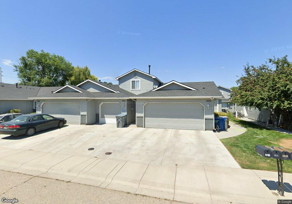
This home is located at 1020 E Hawaii Ave, Nampa, ID 83686 and is currently estimated at $291,180, approximately $96 per square foot. 1020 E Hawaii Ave is a home located in Canyon County with nearby schools including Sherman Elementary School, West Middle School, and Nampa Senior High School.
Ownership History
Date
Name
Owned For
Owner Type
Purchase Details
Closed on
Feb 9, 2012
Sold by
Arnoldus Clinton L and Arnoldus Lesley T
Bought by
Prime Properties Of Idaho Llc
Current Estimated Value
Purchase Details
Closed on
Jan 27, 2012
Sold by
Griffin David G and Griffin Diane H
Bought by
Arnoldus Clinton L and Arnoldus Lesley T
Purchase Details
Closed on
May 23, 2011
Sold by
Coble Duane R and Coble Becky L
Bought by
Griffin David D and Griffin Diane H
Create a Home Valuation Report for This Property
The Home Valuation Report is an in-depth analysis detailing your home's value as well as a comparison with similar homes in the area
Home Values in the Area
Average Home Value in this Area
Purchase History
| Date | Buyer | Sale Price | Title Company |
|---|---|---|---|
| Prime Properties Of Idaho Llc | -- | None Available | |
| Arnoldus Clinton L | -- | Stewart Title Emerald O | |
| Griffin David D | -- | Stewart Title Emerald O |
Source: Public Records
Tax History Compared to Growth
Tax History
| Year | Tax Paid | Tax Assessment Tax Assessment Total Assessment is a certain percentage of the fair market value that is determined by local assessors to be the total taxable value of land and additions on the property. | Land | Improvement |
|---|---|---|---|---|
| 2025 | $746 | $245,600 | $92,100 | $153,500 |
| 2024 | $746 | $242,600 | $81,900 | $160,700 |
| 2023 | $1,801 | $239,100 | $81,900 | $157,200 |
| 2022 | $1,726 | $233,800 | $92,100 | $141,700 |
| 2021 | $2,065 | $175,300 | $43,000 | $132,300 |
| 2020 | $1,236 | $152,300 | $30,500 | $121,800 |
| 2019 | $1,327 | $137,700 | $28,500 | $109,200 |
| 2018 | $2,104 | $0 | $0 | $0 |
| 2017 | $2,008 | $0 | $0 | $0 |
| 2016 | $1,688 | $0 | $0 | $0 |
| 2015 | $797 | $0 | $0 | $0 |
| 2014 | $1,263 | $64,800 | $11,500 | $53,300 |
Source: Public Records
Map
Nearby Homes
- 1300 Diamond Ct
- 1157 S Powerline Rd
- 702 E Maryland Ave
- 1912 S Locust St
- 1835 E Kentucky Ave
- 1207 E Sheridan Ave
- 1047 S 20th St
- 520 S Powerline Rd
- 1017 S Maple St
- 1020 S Maple St
- 525 E Greenhurst Rd
- 712 E Sheridan Ave
- 2019 Kentucky Dr
- 416 S Powerline Rd
- 618 Dufur St
- TBD Maple St
- 711 Nectarine St
- 223 S Elder St
- 115 E Clark Ave
- 2308 E Elm Grove Dr
- 1020 E Hawaii Ave
- 1018 E Hawaii Ave
- 1018 E Hawaii Ave
- 1022 E Hawaii Ave
- 1014 E Hawaii Ave
- 1026 E Hawaii Ave
- 1012 E Hawaii Ave
- 1028 E Hawaii Ave
- 1012 E Hawaii Ave
- 1321/1323/ Diamond Ct
- 1321 Diamond Ct
- 1030 E Hawaii Ave
- 1323 Diamond Ct
- 1317 Diamond Ct
- 1325 Diamond Ct
- 1315 Diamond Ct
- 1315 Diamond Ct
- 1311 Diamond Ct
- 1322 S Elder St
- 1420 S Elder St