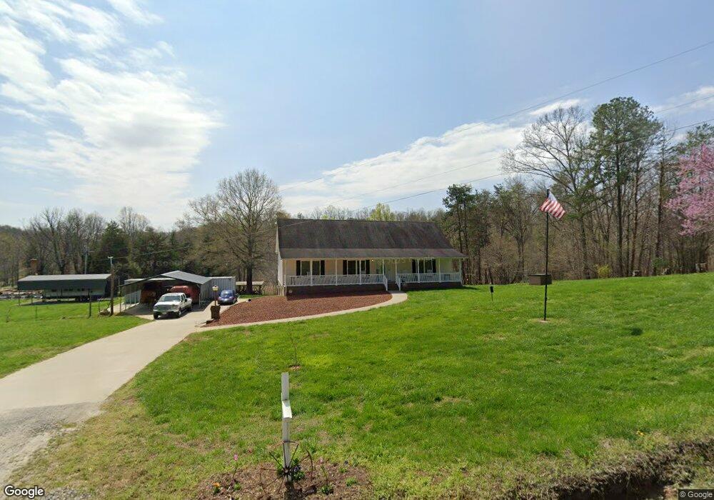
1020 Francis Rd Westfield, NC 27053
Estimated Value: $262,000 - $393,000
3
Beds
2
Baths
1,568
Sq Ft
$198/Sq Ft
Est. Value
About This Home
This home is located at 1020 Francis Rd, Westfield, NC 27053 and is currently estimated at $310,212, approximately $197 per square foot. 1020 Francis Rd is a home located in Stokes County with nearby schools including Nancy Reynolds Elementary School, Piney Grove Middle, and North Stokes High.
Ownership History
Date
Name
Owned For
Owner Type
Purchase Details
Closed on
Oct 17, 2005
Sold by
Francis Timothy L and Francis Wanda H
Bought by
Francis Timothy L and Francis Wanda H
Current Estimated Value
Home Financials for this Owner
Home Financials are based on the most recent Mortgage that was taken out on this home.
Original Mortgage
$150,100
Interest Rate
5.66%
Mortgage Type
Construction
Create a Home Valuation Report for This Property
The Home Valuation Report is an in-depth analysis detailing your home's value as well as a comparison with similar homes in the area
Home Values in the Area
Average Home Value in this Area
Purchase History
| Date | Buyer | Sale Price | Title Company |
|---|---|---|---|
| Francis Timothy L | -- | Chicago Title Insurance Co |
Source: Public Records
Mortgage History
| Date | Status | Borrower | Loan Amount |
|---|---|---|---|
| Closed | Francis Timothy L | $150,100 |
Source: Public Records
Tax History Compared to Growth
Tax History
| Year | Tax Paid | Tax Assessment Tax Assessment Total Assessment is a certain percentage of the fair market value that is determined by local assessors to be the total taxable value of land and additions on the property. | Land | Improvement |
|---|---|---|---|---|
| 2025 | $1,754 | $245,300 | $15,500 | $229,800 |
| 2024 | $1,754 | $169,900 | $12,200 | $157,700 |
| 2023 | $1,376 | $169,900 | $12,200 | $157,700 |
| 2022 | $1,257 | $169,900 | $12,200 | $157,700 |
| 2021 | $1,257 | $169,900 | $12,200 | $157,700 |
| 2020 | $1,106 | $149,500 | $11,100 | $138,400 |
| 2019 | $1,106 | $149,500 | $11,100 | $138,400 |
| 2018 | $1,106 | $149,500 | $11,100 | $138,400 |
| 2017 | $1,099 | $149,500 | $11,100 | $138,400 |
| 2016 | $1,083 | $147,300 | $11,100 | $136,200 |
| 2015 | $1,075 | $147,300 | $11,100 | $136,200 |
| 2014 | $1,070 | $147,300 | $11,100 | $136,200 |
Source: Public Records
Map
Nearby Homes
- 1934 N Carolina 66
- 1135 Daisy Creek Farm Rd
- 0 Joyce Acres Rd
- 0 Dearmin Rd Unit 25131549
- 0 Dearmin Rd Unit 25132044
- 0 Dearmin Rd Unit 25131530
- 0 Dearmin Rd Unit 1198608
- 0 Dearmin Rd Unit 1198590
- 00 Jackson Rd
- 0 Sunset Ridge Rd
- 1561 Horseshoe Rd
- 74.83 Windy Hill Rd
- 1125 Apple Blossom Ln
- 3.9Ac Pell Rd
- 0 Wildlife Rd Unit 1196047
- TBD Rogers Rd Unit TBD Rogers Road
- 00 Albion Church Rd
- 1311 Flippin Rd
- 1507 Rogers Rd
- 1202 Farm Rd
- 1040 Francis Rd
- 8849 Nc Highway 89 W
- 8786 Nc 89 Hwy W
- 8849 Nc 89 Hwy W
- 8849 Nc-89 W
- 8917 Nc 89 Hwy W
- 8999 Nc 89 Hwy W
- 8936 Nc 89 Hwy W
- 8958 Nc 89 Hwy W
- 8958 Nc Highway 89 W
- 8681 Nc 89 Hwy W
- 9007 Nc 89 Hwy W
- 1090 Cold River Run Rd
- 9014 Nc Highway 89 W
- 9029 Nc Highway 89 W
- 1320 Francis Rd
- 8614 Nc 89 Hwy W
- 9082 Nc 89 Hwy W
- 9058 Nc Highway 89 W
- 1271 Francis Rd