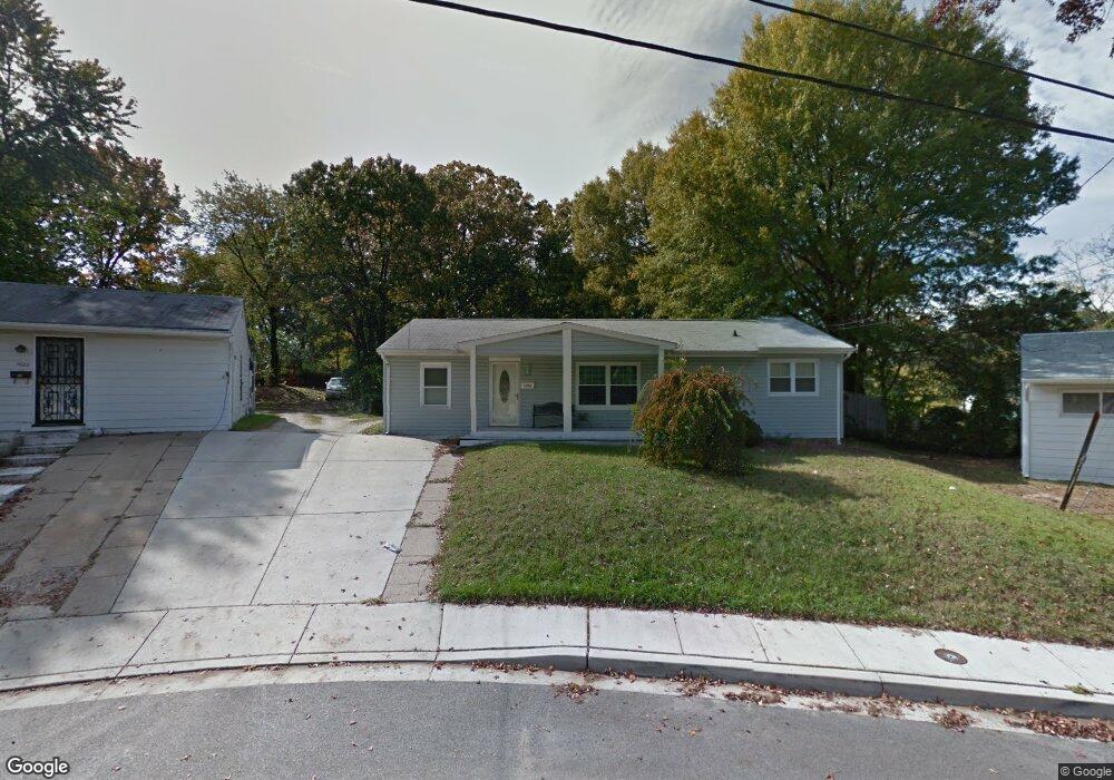
1020 Guy Dr Glen Burnie, MD 21061
Estimated Value: $304,661 - $378,000
Studio
1
Bath
1,272
Sq Ft
$269/Sq Ft
Est. Value
About This Home
This home is located at 1020 Guy Dr, Glen Burnie, MD 21061 and is currently estimated at $341,915, approximately $268 per square foot. 1020 Guy Dr is a home located in Anne Arundel County with nearby schools including Oakwood Elementary School, Corkran Middle School, and Glen Burnie High School.
Ownership History
Date
Name
Owned For
Owner Type
Purchase Details
Closed on
Mar 3, 2020
Sold by
Kulik Susan V and Estate Of M Virginia Price
Bought by
S Goldberg Custodian Llc
Current Estimated Value
Purchase Details
Closed on
Sep 18, 1991
Sold by
Schipper James L
Bought by
Gauniel 2Nd Paul W and Gauniel Mary E
Home Financials for this Owner
Home Financials are based on the most recent Mortgage that was taken out on this home.
Original Mortgage
$88,300
Interest Rate
9.02%
Create a Home Valuation Report for This Property
The Home Valuation Report is an in-depth analysis detailing your home's value as well as a comparison with similar homes in the area
Home Values in the Area
Average Home Value in this Area
Purchase History
| Date | Buyer | Sale Price | Title Company |
|---|---|---|---|
| S Goldberg Custodian Llc | $1,440 | Ridge Title Company Inc | |
| Gauniel 2Nd Paul W | $86,700 | -- |
Source: Public Records
Mortgage History
| Date | Status | Borrower | Loan Amount |
|---|---|---|---|
| Previous Owner | Gauniel 2Nd Paul W | $88,300 |
Source: Public Records
Tax History
| Year | Tax Paid | Tax Assessment Tax Assessment Total Assessment is a certain percentage of the fair market value that is determined by local assessors to be the total taxable value of land and additions on the property. | Land | Improvement |
|---|---|---|---|---|
| 2025 | $3,197 | $259,500 | $157,800 | $101,700 |
| 2024 | $3,197 | $246,100 | $0 | $0 |
| 2023 | $3,015 | $232,700 | $0 | $0 |
| 2022 | $2,722 | $219,300 | $142,800 | $76,500 |
| 2020 | $2,681 | $219,300 | $142,800 | $76,500 |
| 2019 | $2,694 | $220,300 | $137,800 | $82,500 |
| 2018 | $2,101 | $207,167 | $0 | $0 |
| 2017 | $2,360 | $194,033 | $0 | $0 |
| 2016 | -- | $180,900 | $0 | $0 |
| 2015 | -- | $173,100 | $0 | $0 |
| 2014 | -- | $165,300 | $0 | $0 |
Source: Public Records
Map
Nearby Homes
- 208 Gloucester Dr
- 1210 Cathedral Dr
- 1208 Montgomery Dr
- 303 Oxford Dr
- 211 Aquahart Rd
- 505 Aquahart Rd
- 1200 Whitman Dr
- 265 Truck Farm Dr
- 106 Heather Stone Way Unit 43
- 273 Maxo Ct
- 285 Maxo Ct
- 1106 Curtis Way
- 403 Arbor Dr
- 7510 Resch Loop
- 5717 Howard Dr
- 7711 Allen Wood Ct
- 1003 Lee Rd
- 7819 Five Oaks Ct
- 24 Main Ave SW
- 518 Kintop Rd
- 1022 Guy Dr
- 1018 Guy Dr
- 205 Saint James Place
- 203 Saint James Place
- 1024 Guy Dr
- 1016 Guy Dr
- 204 Saint James Place
- 1011 Guy Dr
- 202 Gloucester Dr
- 200 Gloucester Dr
- 204 Gloucester Dr
- 1026 Guy Dr
- 206 Saint James Dr
- 1014 Guy Dr
- 1009 Guy Dr
- 204 Saint James Dr
- 208 Saint James Dr
- 206 Gloucester Dr
- 202 Saint James Dr
- 202 Saint James Place
Your Personal Tour Guide
Ask me questions while you tour the home.