Estimated Value: $68,000 - $100,000
3
Beds
1
Bath
1,036
Sq Ft
$82/Sq Ft
Est. Value
About This Home
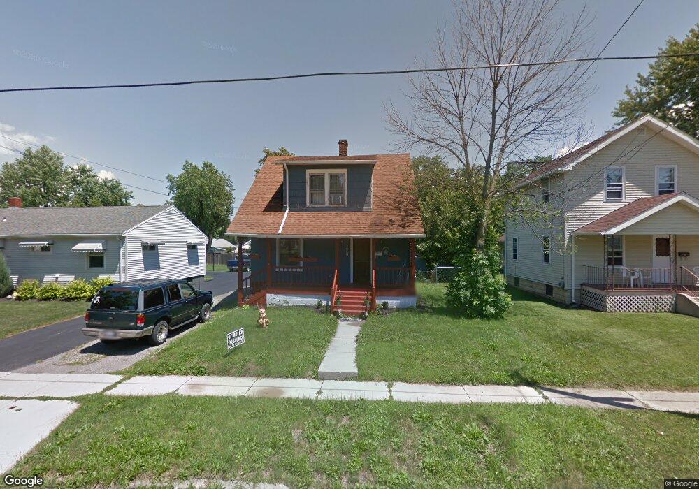
This home is located at 1020 N Union St, Lima, OH 45801 and is currently estimated at $85,382, approximately $82 per square foot. 1020 N Union St is a home located in Allen County with nearby schools including Independence Elementary School, Lima North Middle School, and Lima West Middle School.
Ownership History
Date
Name
Owned For
Owner Type
Purchase Details
Closed on
Jan 11, 2023
Sold by
Croft Joseph
Bought by
Smith Matthew and Norman Samantha
Current Estimated Value
Purchase Details
Closed on
Dec 2, 2022
Sold by
Conner Jessica and Conner Christopher
Bought by
Croft Joe and Herr Nicole
Purchase Details
Closed on
Feb 12, 2015
Sold by
Lawrence Cathy L
Bought by
Conner Jessica
Purchase Details
Closed on
Apr 18, 1986
Bought by
Lawrence Franklin E D
Create a Home Valuation Report for This Property
The Home Valuation Report is an in-depth analysis detailing your home's value as well as a comparison with similar homes in the area
Home Values in the Area
Average Home Value in this Area
Purchase History
| Date | Buyer | Sale Price | Title Company |
|---|---|---|---|
| Smith Matthew | $90,600 | -- | |
| Croft Joe | $20,000 | -- | |
| Conner Jessica | -- | None Available | |
| Lawrence Franklin E D | $28,800 | -- |
Source: Public Records
Tax History Compared to Growth
Tax History
| Year | Tax Paid | Tax Assessment Tax Assessment Total Assessment is a certain percentage of the fair market value that is determined by local assessors to be the total taxable value of land and additions on the property. | Land | Improvement |
|---|---|---|---|---|
| 2024 | $754 | $19,400 | $2,980 | $16,420 |
| 2023 | $745 | $15,270 | $2,350 | $12,920 |
| 2022 | $674 | $15,270 | $2,350 | $12,920 |
| 2021 | $713 | $15,270 | $2,350 | $12,920 |
| 2020 | $651 | $12,260 | $2,280 | $9,980 |
| 2019 | $651 | $12,260 | $2,280 | $9,980 |
| 2018 | $649 | $12,260 | $2,280 | $9,980 |
| 2017 | $653 | $12,260 | $2,280 | $9,980 |
| 2016 | $660 | $12,260 | $2,280 | $9,980 |
| 2015 | $627 | $12,260 | $2,280 | $9,980 |
| 2014 | $627 | $11,520 | $2,240 | $9,280 |
| 2013 | $611 | $11,520 | $2,240 | $9,280 |
Source: Public Records
Map
Nearby Homes
- 123 Flanders Ave
- 1200 N Main St
- 939 N West St
- 222 W Grand Ave
- 735 N Main St
- 616 N Elizabeth St
- 340 W Robb Ave
- 606 N West St
- 128 E Lane Ave
- 622 N Jefferson St
- 416 Hazel Ave
- 711 Taylor Ave
- 608 W O'Connor Ave
- 14 House Package
- 439 E Mckibben St
- 610 W Robb Ave
- 708 N Metcalf St
- 576 Cortlandt Ave
- 1116 Belvidere Ave
- 612 N Metcalf St
- 1014 N Union St
- 1014 N Union St
- 1028 N Union St
- 1010 N Union St
- 1034 N Union St
- 1006 N Union St
- 1021 N Central Ave
- 1019 N Central Ave
- 1023 N Central Ave
- 211 E Edwards St
- 1017 N Central Ave
- 1025 N Central Ave
- 203 E Edwards St
- 1040 N Union St
- 1031 N Central Ave
- 1007 N Central Ave
- 1015 N Union St
- 1007 N Union St
- 1001 N Central Ave
- 1033 N Central Ave