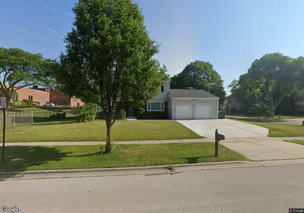
1020 Plum Grove Cir Buffalo Grove, IL 60089
South Buffalo Grove NeighborhoodEstimated Value: $444,000 - $520,678
4
Beds
3
Baths
2,068
Sq Ft
$236/Sq Ft
Est. Value
About This Home
This home is located at 1020 Plum Grove Cir, Buffalo Grove, IL 60089 and is currently estimated at $488,170, approximately $236 per square foot. 1020 Plum Grove Cir is a home located in Cook County with nearby schools including Henry W Longfellow Elementary School, Cooper Middle School, and Buffalo Grove High School.
Ownership History
Date
Name
Owned For
Owner Type
Purchase Details
Closed on
Nov 3, 1998
Sold by
Parker Jeffrey T and Parker Lorraine R
Bought by
Parker Lorraine R and Parker Jeffrey T
Current Estimated Value
Purchase Details
Closed on
Sep 24, 1993
Sold by
The Marilyn K Parker Revocable Living Tr
Bought by
Parker Jeffrey T and Parker Lorraine R
Home Financials for this Owner
Home Financials are based on the most recent Mortgage that was taken out on this home.
Original Mortgage
$144,000
Interest Rate
6.93%
Create a Home Valuation Report for This Property
The Home Valuation Report is an in-depth analysis detailing your home's value as well as a comparison with similar homes in the area
Home Values in the Area
Average Home Value in this Area
Purchase History
| Date | Buyer | Sale Price | Title Company |
|---|---|---|---|
| Parker Lorraine R | -- | -- | |
| Parker Jeffrey T | $120,000 | -- |
Source: Public Records
Mortgage History
| Date | Status | Borrower | Loan Amount |
|---|---|---|---|
| Closed | Parker Jeffrey T | $144,000 |
Source: Public Records
Tax History Compared to Growth
Tax History
| Year | Tax Paid | Tax Assessment Tax Assessment Total Assessment is a certain percentage of the fair market value that is determined by local assessors to be the total taxable value of land and additions on the property. | Land | Improvement |
|---|---|---|---|---|
| 2024 | $12,061 | $41,000 | $8,910 | $32,090 |
| 2023 | $11,572 | $41,000 | $8,910 | $32,090 |
| 2022 | $11,572 | $41,000 | $8,910 | $32,090 |
| 2021 | $9,860 | $31,240 | $5,692 | $25,548 |
| 2020 | $9,674 | $31,240 | $5,692 | $25,548 |
| 2019 | $9,662 | $34,635 | $5,692 | $28,943 |
| 2018 | $10,972 | $35,294 | $4,950 | $30,344 |
| 2017 | $10,790 | $35,294 | $4,950 | $30,344 |
| 2016 | $10,301 | $35,294 | $4,950 | $30,344 |
| 2015 | $9,038 | $29,228 | $4,207 | $25,021 |
| 2014 | $8,907 | $29,228 | $4,207 | $25,021 |
| 2013 | $8,215 | $29,228 | $4,207 | $25,021 |
Source: Public Records
Map
Nearby Homes
- 921 Bernard Dr
- 329 Timber Hill Rd
- 408 Indian Hill Dr
- 1130 Bernard Dr
- 98 Stonegate Rd
- 410 Chatham Cir
- 535 Estate Dr
- 859 Beechwood Rd
- 476 W Happfield Dr Unit 10AL
- 4116 N Terramere Ave
- 720 Weidner Rd Unit 302
- 813 Stradford Cir Unit 21B2
- 715 W Whiting Ln
- 780 Weidner Rd Unit 300
- 705 Grove Dr Unit 101
- 812 W Whiting Ln
- 1112 Auburn Ln
- 820 Weidner Rd Unit 409
- 455 Mayfair Ln
- 310 Rosewood Ave
- 244 Stonegate Rd
- 230 Stonegate Rd
- 1015 Plum Grove Cir
- 253 Stonegate Rd Unit 3
- 1009 Plum Grove Cir
- 1033 Plum Grove Cir
- 235 Stonegate Rd
- 997 Plum Grove Cir
- 1043 Plum Grove Cir
- 972 Plum Grove Cir
- 221 Stonegate Rd
- 985 Plum Grove Cir
- 5 Bernard Ct
- 4 Bernard Ct
- 293 Indian Hill Dr
- 208 Stonegate Rd
- 270 Terrace Place
- 983 Country Ln
- 962 Plum Grove Cir
- 186 Stonegate Rd