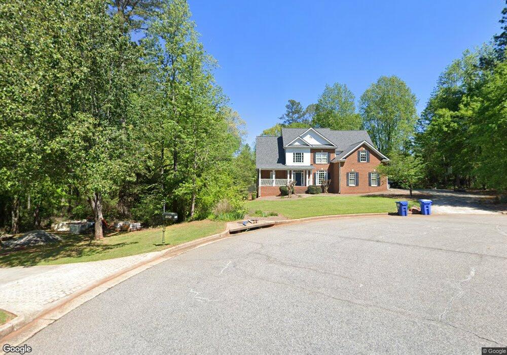
1020 Rocky Branch Trail Bogart, GA 30622
Estimated Value: $664,428 - $728,000
5
Beds
4
Baths
2,766
Sq Ft
$251/Sq Ft
Est. Value
About This Home
This home is located at 1020 Rocky Branch Trail, Bogart, GA 30622 and is currently estimated at $695,107, approximately $251 per square foot. 1020 Rocky Branch Trail is a home located in Oconee County with nearby schools including Rocky Branch Elementary School, Malcom Bridge Middle School, and North Oconee High School.
Ownership History
Date
Name
Owned For
Owner Type
Purchase Details
Closed on
Feb 27, 2020
Sold by
Deaton Paul
Bought by
Mcgahee Thomas Patrick and Mcgahee Jessica Smith
Current Estimated Value
Home Financials for this Owner
Home Financials are based on the most recent Mortgage that was taken out on this home.
Original Mortgage
$343,920
Outstanding Balance
$304,590
Interest Rate
3.5%
Mortgage Type
New Conventional
Estimated Equity
$390,517
Purchase Details
Closed on
Sep 6, 2017
Sold by
English Charlotte C
Bought by
Deaton Paul and Deaton Erin
Home Financials for this Owner
Home Financials are based on the most recent Mortgage that was taken out on this home.
Original Mortgage
$303,050
Interest Rate
3.9%
Mortgage Type
New Conventional
Purchase Details
Closed on
Sep 7, 2011
Sold by
English Charles Brown
Bought by
English Charlotte Chandley
Purchase Details
Closed on
Jan 17, 2003
Sold by
Mab Homebuilders Inc
Bought by
English Charlie and English Charlotte
Create a Home Valuation Report for This Property
The Home Valuation Report is an in-depth analysis detailing your home's value as well as a comparison with similar homes in the area
Home Values in the Area
Average Home Value in this Area
Purchase History
| Date | Buyer | Sale Price | Title Company |
|---|---|---|---|
| Mcgahee Thomas Patrick | $429,900 | -- | |
| Deaton Paul | $319,000 | -- | |
| English Charlotte Chandley | -- | -- | |
| English Charlie | $302,900 | -- |
Source: Public Records
Mortgage History
| Date | Status | Borrower | Loan Amount |
|---|---|---|---|
| Open | Mcgahee Thomas Patrick | $343,920 | |
| Previous Owner | Deaton Paul | $303,050 |
Source: Public Records
Tax History Compared to Growth
Tax History
| Year | Tax Paid | Tax Assessment Tax Assessment Total Assessment is a certain percentage of the fair market value that is determined by local assessors to be the total taxable value of land and additions on the property. | Land | Improvement |
|---|---|---|---|---|
| 2024 | $4,557 | $237,186 | $36,000 | $201,186 |
| 2023 | $4,469 | $219,037 | $28,000 | $191,037 |
| 2022 | $4,209 | $194,442 | $28,000 | $166,442 |
| 2021 | $3,859 | $165,089 | $22,000 | $143,089 |
| 2020 | $3,507 | $149,668 | $20,000 | $129,668 |
| 2019 | $3,074 | $143,322 | $20,000 | $123,322 |
| 2018 | $3,350 | $139,870 | $20,000 | $119,870 |
| 2017 | $2,975 | $124,048 | $20,000 | $104,048 |
| 2016 | $2,841 | $118,392 | $20,000 | $98,392 |
| 2015 | $2,826 | $117,510 | $20,000 | $97,510 |
| 2014 | $2,799 | $113,726 | $20,000 | $93,726 |
| 2013 | -- | $109,620 | $20,000 | $89,620 |
Source: Public Records
Map
Nearby Homes
- 1496 Malcom Estates Dr
- 1224 Malcom Estates Point Unit Lot 67
- 1381 Mayfair Way
- 3065 Brookhaven Dr
- 1491 Virgil Langford Rd
- 1895 Vintage Place
- 0 Us 53 Hwy Unit 10376334
- 2165 Harperfield Dr
- 1105 Harperfield Dr
- 1190 Wareview Ct
- 0 Clotfelter Rd Unit 1025303
- 1010 Long Creek Dr
- 1479 Mcfall Ct
- 1071 Oaklake Cir
- 2082 Wade Dr
- 2163 Heather Ln
- 1336 Prince Place
- 1021 Rocky Branch Trail
- 1041 Branch Farm Point
- 1051 Farm Branch Pointe
- 1051 Branch Farm Point
- 1090 Rocky Branch Farm Dr
- 1031 Branch Farm Point
- 1031 Branch Farm Pointe
- 1591 Malcom Bridge Rd Unit &1593
- 1591 Malcom Bridge Rd
- 1591 Malcom Bridge Rd
- 1593 Malcom Bridge Rd
- 1110(13) Rocky Branch Farms Dr
- 1110 Rocky Branch Farm Dr
- 1130(12) Rocky Branch Farms Dr
- 1130 Rocky Branch Farm Dr
- 1060 Rocky Branch Farm Dr
- 1281 Crimson Ct
- 1282 Crimson Ct
- 1036 Crimson Ct
- 1109 Crimson Ct