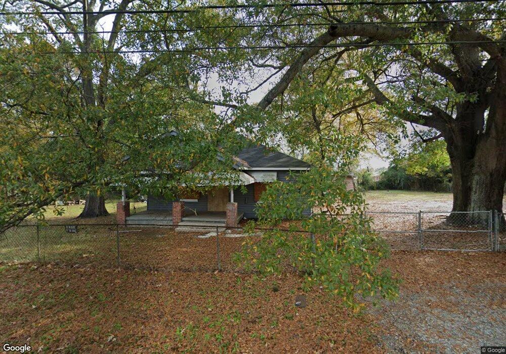
1020 Sheridan Ave Columbus, GA 31903
Estimated Value: $40,000 - $64,000
2
Beds
2
Baths
1,170
Sq Ft
$45/Sq Ft
Est. Value
About This Home
This home is located at 1020 Sheridan Ave, Columbus, GA 31903 and is currently estimated at $52,187, approximately $44 per square foot. 1020 Sheridan Ave is a home located in Muscogee County with nearby schools including Dorothy Height Elementary School, Baker Middle School, and Spencer High School.
Ownership History
Date
Name
Owned For
Owner Type
Purchase Details
Closed on
Oct 31, 2018
Sold by
Adams Earl E
Bought by
Adams Ashley N
Current Estimated Value
Purchase Details
Closed on
Mar 3, 2018
Sold by
Harbour Portfolio Vii Lp
Bought by
Adams Ear A
Purchase Details
Closed on
Oct 22, 2015
Sold by
Adams Earl E
Bought by
Adams Ashley N
Purchase Details
Closed on
Sep 23, 2011
Sold by
Federal National Mortgage Association
Bought by
Harbour Portfolio Vii Lp
Purchase Details
Closed on
Apr 5, 2011
Sold by
Suntrust Mtg Inc
Bought by
Federal National Mtg Associati
Create a Home Valuation Report for This Property
The Home Valuation Report is an in-depth analysis detailing your home's value as well as a comparison with similar homes in the area
Home Values in the Area
Average Home Value in this Area
Purchase History
| Date | Buyer | Sale Price | Title Company |
|---|---|---|---|
| Adams Ashley N | -- | -- | |
| Adams Ear A | $13,800 | -- | |
| Adams Ashley N | -- | -- | |
| Harbour Portfolio Vii Lp | $8,546 | -- | |
| Federal National Mtg Associati | $38,753 | -- | |
| Suntrust Mtg Inc | $38,753 | -- |
Source: Public Records
Tax History Compared to Growth
Tax History
| Year | Tax Paid | Tax Assessment Tax Assessment Total Assessment is a certain percentage of the fair market value that is determined by local assessors to be the total taxable value of land and additions on the property. | Land | Improvement |
|---|---|---|---|---|
| 2025 | $804 | $20,544 | $5,580 | $14,964 |
| 2024 | $804 | $20,544 | $5,580 | $14,964 |
| 2023 | $809 | $20,544 | $5,580 | $14,964 |
| 2022 | $806 | $19,740 | $5,580 | $14,160 |
| 2021 | $853 | $18,652 | $5,580 | $13,072 |
| 2020 | $762 | $18,652 | $5,580 | $13,072 |
| 2019 | $764 | $18,652 | $5,580 | $13,072 |
| 2018 | $764 | $18,652 | $5,580 | $13,072 |
| 2017 | $767 | $18,652 | $5,580 | $13,072 |
| 2016 | $424 | $10,287 | $3,570 | $6,717 |
| 2015 | $170 | $10,287 | $3,570 | $6,717 |
| 2014 | $170 | $10,287 | $3,570 | $6,717 |
| 2013 | -- | $10,287 | $3,570 | $6,717 |
Source: Public Records
Map
Nearby Homes
- 1025 Fletcher Ave
- 917 Fletcher Ave
- 812 Benning Dr
- 906 Winston Rd
- 824 Winston Rd
- 716 Benning Dr
- 903 Winston Rd
- 750 Winston Rd
- 920 Brooks Rd
- 3135 Baker Cir
- 1029 Harbison Dr
- 1401 Clark Ave
- 3111 Baker Cir
- 3223 Lee St
- 1474 Brewer Ave
- 1274 Providence Ln
- 2459 Brownie Ln
- 2463 Brownie Ln
- 2451 Brownie Ln
- 2916 Lee St
- 1028 Sheridan Ave
- 1032 Sheridan Ave
- 1008 Sheridan Ave
- 1027 Fort Benning Rd
- 1004 Sheridan Ave
- 1021 Sheridan Ave
- 1025 Sheridan Ave
- 1029 Sheridan Ave
- 1013 Sheridan Ave
- 1031 Sheridan Ave
- 3703 Youmans St
- 3711 Youmans St
- 932 Sheridan Ave
- 1005 Sheridan Ave
- 933 Fort Benning Rd
- 920 Sheridan Ave
- 3619 Youmans St
- 929 Sheridan Ave
- 933 Sheridan Ave
- 918 Sheridan Ave