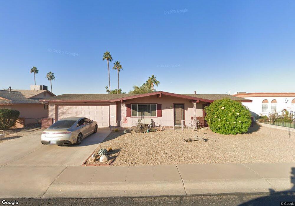
10208 N 101st Ave Sun City, AZ 85351
Estimated Value: $212,094 - $259,000
--
Bed
1
Bath
1,149
Sq Ft
$204/Sq Ft
Est. Value
About This Home
This home is located at 10208 N 101st Ave, Sun City, AZ 85351 and is currently estimated at $234,274, approximately $203 per square foot. 10208 N 101st Ave is a home located in Maricopa County with nearby schools including Desert Mirage Elementary School, Ombudsman - Northwest Charter, and Peoria Accelerated High School.
Ownership History
Date
Name
Owned For
Owner Type
Purchase Details
Closed on
May 14, 2022
Sold by
Morehead William R and Morehead Jo Mary
Bought by
Morehead Family Trust
Current Estimated Value
Purchase Details
Closed on
May 21, 1998
Sold by
Klassen Tillie S
Bought by
Morehead William R and Morehead Mary Jo
Home Financials for this Owner
Home Financials are based on the most recent Mortgage that was taken out on this home.
Original Mortgage
$42,000
Interest Rate
7.17%
Create a Home Valuation Report for This Property
The Home Valuation Report is an in-depth analysis detailing your home's value as well as a comparison with similar homes in the area
Home Values in the Area
Average Home Value in this Area
Purchase History
| Date | Buyer | Sale Price | Title Company |
|---|---|---|---|
| Morehead Family Trust | -- | None Listed On Document | |
| Morehead William R | $60,000 | First American Title |
Source: Public Records
Mortgage History
| Date | Status | Borrower | Loan Amount |
|---|---|---|---|
| Previous Owner | Morehead William R | $42,000 |
Source: Public Records
Tax History Compared to Growth
Tax History
| Year | Tax Paid | Tax Assessment Tax Assessment Total Assessment is a certain percentage of the fair market value that is determined by local assessors to be the total taxable value of land and additions on the property. | Land | Improvement |
|---|---|---|---|---|
| 2025 | $776 | $9,544 | -- | -- |
| 2024 | $695 | $9,089 | -- | -- |
| 2023 | $695 | $18,250 | $3,650 | $14,600 |
| 2022 | $650 | $14,180 | $2,830 | $11,350 |
| 2021 | $672 | $13,050 | $2,610 | $10,440 |
| 2020 | $654 | $11,520 | $2,300 | $9,220 |
| 2019 | $650 | $10,470 | $2,090 | $8,380 |
| 2018 | $628 | $9,260 | $1,850 | $7,410 |
| 2017 | $610 | $8,110 | $1,620 | $6,490 |
| 2016 | $568 | $7,520 | $1,500 | $6,020 |
| 2015 | $542 | $6,800 | $1,360 | $5,440 |
Source: Public Records
Map
Nearby Homes
- 10034 W Concord Ave
- 10027 W Tarrytown Ave Unit 6
- 10102 W Deanne Dr Unit 6
- 10240 W Concord Ave
- 10010 W Deanne Dr
- 10002 W Deanne Dr
- 10076 W Peoria Ave
- 10131 W Cheryl Dr Unit 6D
- 10314 W Deanne Dr
- 10166 W Cinnebar Ave
- 10425 N Balboa Dr
- 10341 W Clair Dr
- 10318 W Corte Del Sol Este Unit 21
- 10302 W Cheryl Dr Unit D
- 10323 W Deanne Dr
- 10614 N 103rd Ave
- 9939 W Ironwood Dr Unit 6D
- 10404 W Audrey Dr
- 10635 N 103rd Ave
- 10345 W Peoria Ave Unit 5
- 10202 N 101st Ave
- 10214 N 101st Ave Unit 6
- 10121 W Clair Dr
- 10038 N 101st Ave
- 10122 W Camden Ave
- 10116 W Camden Ave Unit 6
- 10127 W Clair Dr
- 10032 N 101st Ave
- 10110 W Clair Dr
- 10120 W Clair Dr
- 10110 W Camden Ave
- 10135 W Clair Dr
- 10045 W Clair Dr
- 10102 W Clair Dr
- 10126 W Clair Dr
- 10126 W Camden Ave
- 10026 N 101st Ave Unit 6
- 10132 W Clair Dr
- 10102 W Camden Ave Unit 6
- 10141 W Clair Dr