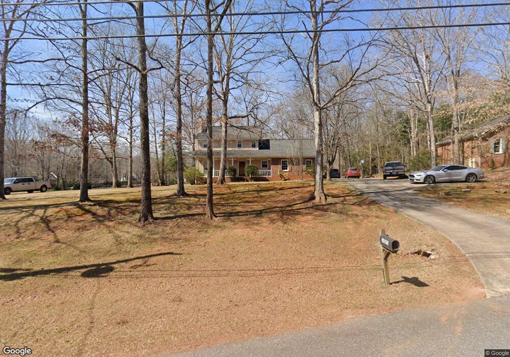
1021 Barnett Place Athens, GA 30605
Estimated Value: $443,932 - $580,000
4
Beds
3
Baths
2,454
Sq Ft
$206/Sq Ft
Est. Value
About This Home
This home is located at 1021 Barnett Place, Athens, GA 30605 and is currently estimated at $505,233, approximately $205 per square foot. 1021 Barnett Place is a home located in Oconee County with nearby schools including Colham Ferry Elementary School, Oconee County Middle School, and Oconee County High School.
Ownership History
Date
Name
Owned For
Owner Type
Purchase Details
Closed on
Dec 31, 2002
Sold by
Coker Deborah G
Bought by
Coker David W
Current Estimated Value
Purchase Details
Closed on
Dec 1, 2000
Sold by
Owens Wesley V
Bought by
Coker David W
Purchase Details
Closed on
Mar 3, 1997
Sold by
Stafford George E
Bought by
Owens Wesley V
Create a Home Valuation Report for This Property
The Home Valuation Report is an in-depth analysis detailing your home's value as well as a comparison with similar homes in the area
Home Values in the Area
Average Home Value in this Area
Purchase History
| Date | Buyer | Sale Price | Title Company |
|---|---|---|---|
| Coker David W | -- | -- | |
| Coker David W | $161,500 | -- | |
| Owens Wesley V | $137,000 | -- |
Source: Public Records
Tax History Compared to Growth
Tax History
| Year | Tax Paid | Tax Assessment Tax Assessment Total Assessment is a certain percentage of the fair market value that is determined by local assessors to be the total taxable value of land and additions on the property. | Land | Improvement |
|---|---|---|---|---|
| 2024 | $2,586 | $140,415 | $28,500 | $111,915 |
| 2023 | $2,586 | $133,345 | $28,500 | $104,845 |
| 2022 | $2,477 | $117,476 | $28,500 | $88,976 |
| 2021 | $2,085 | $92,057 | $22,800 | $69,257 |
| 2020 | $1,976 | $87,216 | $22,800 | $64,416 |
| 2019 | $1,877 | $82,934 | $17,100 | $65,834 |
| 2018 | $1,906 | $82,468 | $17,100 | $65,368 |
| 2017 | $1,794 | $77,738 | $17,100 | $60,638 |
| 2016 | $1,573 | $68,432 | $17,100 | $51,332 |
| 2015 | $1,566 | $67,966 | $17,100 | $50,866 |
| 2014 | $1,549 | $65,785 | $17,100 | $48,685 |
| 2013 | -- | $62,831 | $17,100 | $45,731 |
Source: Public Records
Map
Nearby Homes
- 1020 Barnett Place
- 3191 Ryland Hills Dr
- 3291 Ryland Hills Dr
- 3095 Ryland Hills Dr
- 1050 Golf Course Ln
- 3868 Barnett Shoals Rd
- 3910 S Barnett Shoals Rd
- 1200 Ryland Hills Dr
- 1100 Ryland Hills Dr
- 0 Old Barnett Shoals Rd Unit 22878090
- 1181 Old Barnett Shoals Rd
- 0 S Barnett Shoals Rd Unit CL336112
- 0 S Barnett Shoals Rd Unit 10579614
- 4990 Barnett Shoals Rd
- 4225 Bob Godfrey Rd
- 1191 Old Barnett Shoals Rd
- 290 Belmont Rd
- 1020 Belmont Rd
- 2568 Wire Bridge Rd
- 1931 Oliver Bridge Rd
- 1031 Barnett Place
- 1081 Barnett Ridge
- 1035 Barnett Place Unit 449
- 1035 Barnett Place Unit 450
- 1035 Barnett Place Unit 454
- 1035 Barnett Place Unit 420
- 1035 Barnett Place Unit 441
- 1035 Barnett Place Unit 120
- 1035 Barnett Place Unit 622
- 1035 Barnett Place Unit 1240
- 1035 Barnett Place
- 1035 Barnett Place Unit 445
- 1035 Barnett Place Unit 513
- 1035 Barnett Place Unit 512
- 1035 Barnett Place Unit 1230
- 1035 Barnett Place Unit 511
- 1035 Barnett Place Unit 438
- 1035 Barnett Place Unit 1026
- 1035 Barnett Place Unit 1032
- 1035 Barnett Place Unit 125