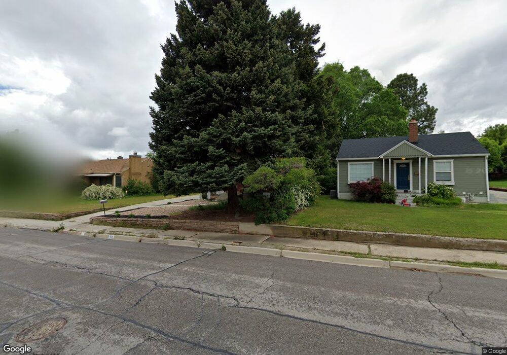
1021 Briar Ave Provo, UT 84604
Wasatch NeighborhoodEstimated Value: $568,000
4
Beds
2
Baths
1,700
Sq Ft
$334/Sq Ft
Est. Value
About This Home
This home is located at 1021 Briar Ave, Provo, UT 84604 and is currently priced at $568,000, approximately $334 per square foot. 1021 Briar Ave is a home located in Utah County with nearby schools including Wasatch Elementary School, Centennial Middle School, and Timpview High School.
Ownership History
Date
Name
Owned For
Owner Type
Purchase Details
Closed on
Apr 22, 2022
Sold by
Grames Christopher T
Bought by
Grames Christopher T and Grames Tana
Current Estimated Value
Home Financials for this Owner
Home Financials are based on the most recent Mortgage that was taken out on this home.
Original Mortgage
$405,000
Outstanding Balance
$378,784
Interest Rate
3.85%
Mortgage Type
New Conventional
Purchase Details
Closed on
Jul 9, 2020
Sold by
Andrus Darlene Ann and Andrus Richard Morris
Bought by
Briarside Llc
Home Financials for this Owner
Home Financials are based on the most recent Mortgage that was taken out on this home.
Original Mortgage
$269,900
Interest Rate
3.1%
Mortgage Type
Unknown
Create a Home Valuation Report for This Property
The Home Valuation Report is an in-depth analysis detailing your home's value as well as a comparison with similar homes in the area
Home Values in the Area
Average Home Value in this Area
Purchase History
| Date | Buyer | Sale Price | Title Company |
|---|---|---|---|
| Grames Christopher T | -- | Cottonwood Title | |
| Briarside Llc | -- | Provo Land Title Co |
Source: Public Records
Mortgage History
| Date | Status | Borrower | Loan Amount |
|---|---|---|---|
| Open | Grames Christopher T | $405,000 | |
| Previous Owner | Briarside Llc | $269,900 |
Source: Public Records
Tax History
| Year | Tax Paid | Tax Assessment Tax Assessment Total Assessment is a certain percentage of the fair market value that is determined by local assessors to be the total taxable value of land and additions on the property. | Land | Improvement |
|---|---|---|---|---|
| 2022 | $2,377 | $232,595 | $0 | $0 |
| 2021 | $1,929 | $329,200 | $185,300 | $143,900 |
| 2020 | $1,808 | $289,300 | $148,200 | $141,100 |
| 2019 | $1,675 | $278,700 | $148,200 | $130,500 |
| 2018 | $1,516 | $255,800 | $141,100 | $114,700 |
| 2017 | $1,373 | $127,325 | $0 | $0 |
| 2016 | $1,338 | $115,665 | $0 | $0 |
| 2015 | $1,215 | $106,095 | $0 | $0 |
| 2014 | $1,082 | $98,505 | $0 | $0 |
Source: Public Records
Map
Nearby Homes
- 990 Cedar Ave
- 1411 N Locust Ln
- 1205 N Old Willow Ln
- 907 E 820 N Unit 11
- 1040 N Oakmont Ln
- 737 E 750 N Unit 1
- 1840 Sego Ln
- 785 E 560 N Unit 405
- 1215 N Terrace Dr
- 905 N Terrace Dr
- 360 Sumac Ln
- 532 N Seven Peaks Blvd Unit 302
- 635 N Ridge Dr Unit 25
- 541 E 500 N Unit 12
- 362 N 800 E
- 948 N 50 E Unit 301
- 1051 E 300 N
- 386 N 500 E
- 364 N 500 E
- 182 E 2090 N
Your Personal Tour Guide
Ask me questions while you tour the home.