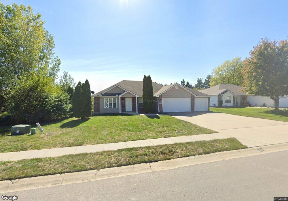
1021 Bristol Dr Raymore, MO 64083
Estimated Value: $296,000 - $321,401
3
Beds
2
Baths
1,350
Sq Ft
$230/Sq Ft
Est. Value
About This Home
This home is located at 1021 Bristol Dr, Raymore, MO 64083 and is currently estimated at $310,850, approximately $230 per square foot. 1021 Bristol Dr is a home located in Cass County with nearby schools including Stonegate Elementary School, Raymore-Peculiar South Middle School, and Raymore-Peculiar Senior High School.
Ownership History
Date
Name
Owned For
Owner Type
Purchase Details
Closed on
Jun 26, 2009
Sold by
Brookside Builders Llc
Bought by
Bebber William R Van and Bebber Carol A Van
Current Estimated Value
Home Financials for this Owner
Home Financials are based on the most recent Mortgage that was taken out on this home.
Original Mortgage
$100,001
Outstanding Balance
$63,590
Interest Rate
4.97%
Mortgage Type
New Conventional
Estimated Equity
$247,260
Purchase Details
Closed on
Sep 9, 2008
Sold by
Brookside Investment Inc
Bought by
Brookside Builders Llc
Home Financials for this Owner
Home Financials are based on the most recent Mortgage that was taken out on this home.
Original Mortgage
$124,000
Interest Rate
6.66%
Mortgage Type
Construction
Create a Home Valuation Report for This Property
The Home Valuation Report is an in-depth analysis detailing your home's value as well as a comparison with similar homes in the area
Home Values in the Area
Average Home Value in this Area
Purchase History
| Date | Buyer | Sale Price | Title Company |
|---|---|---|---|
| Bebber William R Van | -- | None Available | |
| Brookside Builders Llc | -- | -- |
Source: Public Records
Mortgage History
| Date | Status | Borrower | Loan Amount |
|---|---|---|---|
| Open | Bebber William R Van | $100,001 | |
| Previous Owner | Brookside Builders Llc | $124,000 |
Source: Public Records
Tax History
| Year | Tax Paid | Tax Assessment Tax Assessment Total Assessment is a certain percentage of the fair market value that is determined by local assessors to be the total taxable value of land and additions on the property. | Land | Improvement |
|---|---|---|---|---|
| 2025 | $2,783 | $39,000 | $7,070 | $31,930 |
| 2024 | $2,783 | $34,200 | $6,430 | $27,770 |
| 2023 | $2,780 | $34,200 | $6,430 | $27,770 |
| 2022 | $2,553 | $31,210 | $6,430 | $24,780 |
| 2021 | $2,554 | $31,210 | $6,430 | $24,780 |
| 2020 | $2,582 | $31,000 | $6,430 | $24,570 |
| 2019 | $2,493 | $31,000 | $6,430 | $24,570 |
| 2018 | $2,277 | $27,340 | $5,360 | $21,980 |
| 2017 | $2,108 | $27,340 | $5,360 | $21,980 |
| 2016 | $2,108 | $26,280 | $5,360 | $20,920 |
| 2015 | $2,110 | $26,280 | $5,360 | $20,920 |
| 2014 | $2,014 | $25,080 | $5,360 | $19,720 |
| 2013 | -- | $25,080 | $5,360 | $19,720 |
Source: Public Records
Map
Nearby Homes
- 1103 Carlisle Dr
- 727 Country Ln
- 1105 Creekside Ct
- 817 Clancy Ct
- 814 Coventry Ln
- 901 W Lucy Webb Rd
- 1108 Yokley Dr
- 713 S Sunset Ln
- 1510 Colt Cir
- 1519 Colt Cir
- 1227 Larkspur Place
- 1228 Larkspur Place
- 1301 Larkspur Place
- 1309 Larkspur Place
- 1011 Camelback Ct
- 1117 Sendera Trail
- 1009 Balboa Trail
- 1408 Larkspur Place
- 1035 Mission Park Trail
- 1033 Mission Park Trail
- 1023 Bristol Dr
- 1019 Bristol Dr
- 1101 Bristol Dr
- 1017 Bristol Dr
- 1022 Bristol Dr
- 1020 Bristol Dr
- 1148 W Linda Ln
- 1024 Bristol Dr
- 1018 Bristol Dr
- 1103 Bristol Dr
- 1100 Bristol Dr
- 1015 Bristol Dr
- 1016 Bristol Dr
- 1023 Carlisle Dr
- 1021 Carlisle Dr
- 1105 Bristol Dr
- 1102 Bristol Dr
- 1014 Bristol Dr
- 1025 Carlisle Dr
- 1019 Carlisle Dr
Your Personal Tour Guide
Ask me questions while you tour the home.