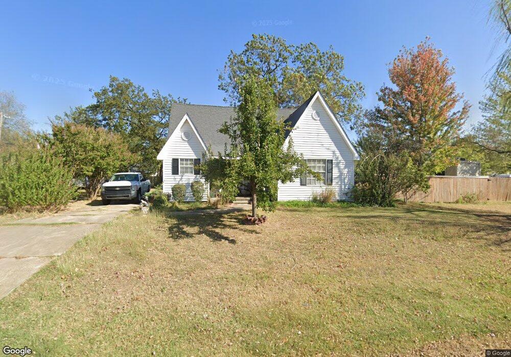
1021 N Beard St Shawnee, OK 74801
Estimated Value: $104,000 - $139,000
3
Beds
2
Baths
1,610
Sq Ft
$75/Sq Ft
Est. Value
About This Home
This home is located at 1021 N Beard St, Shawnee, OK 74801 and is currently estimated at $121,305, approximately $75 per square foot. 1021 N Beard St is a home located in Pottawatomie County with nearby schools including Jefferson Elementary School, Shawnee Middle School, and Shawnee High School.
Ownership History
Date
Name
Owned For
Owner Type
Purchase Details
Closed on
Oct 28, 2021
Sold by
Powers Mattie Lorraine
Bought by
Stegall Linda Diane Powers
Current Estimated Value
Purchase Details
Closed on
Jan 19, 2001
Sold by
Cox Ronald and Cox Thelma
Bought by
Powers Jim L and Powers Lorraine
Purchase Details
Closed on
Oct 27, 1995
Sold by
Reeser Leonard and Reeser Bertha
Bought by
Cox Ronald and Cox Thelma
Purchase Details
Closed on
Oct 29, 1993
Sold by
Isiah'S Lighthouse
Bought by
Reeser Leonard and Cox Ro
Purchase Details
Closed on
Sep 28, 1993
Sold by
Ross Carl and Ross Hirley
Bought by
Isaiah'S Lighthouse
Purchase Details
Closed on
Feb 3, 1993
Sold by
Ersland Edward and Ersland Majorie
Bought by
Isaiah'S Light House
Purchase Details
Closed on
Nov 16, 1992
Sold by
Isaih'S Light House
Bought by
Ersland Edward and Ersland Majorie
Create a Home Valuation Report for This Property
The Home Valuation Report is an in-depth analysis detailing your home's value as well as a comparison with similar homes in the area
Home Values in the Area
Average Home Value in this Area
Purchase History
| Date | Buyer | Sale Price | Title Company |
|---|---|---|---|
| Stegall Linda Diane Powers | -- | None Available | |
| Powers Jim L | $63,000 | -- | |
| Cox Ronald | -- | -- | |
| Reeser Leonard | -- | -- | |
| Isaiah'S Lighthouse | -- | -- | |
| Isaiah'S Light House | -- | -- | |
| Ersland Edward | -- | -- |
Source: Public Records
Tax History Compared to Growth
Tax History
| Year | Tax Paid | Tax Assessment Tax Assessment Total Assessment is a certain percentage of the fair market value that is determined by local assessors to be the total taxable value of land and additions on the property. | Land | Improvement |
|---|---|---|---|---|
| 2024 | $673 | $7,443 | $1,166 | $6,277 |
| 2023 | $673 | $7,443 | $1,312 | $6,131 |
| 2022 | $661 | $7,443 | $1,312 | $6,131 |
| 2021 | $649 | $7,442 | $1,288 | $6,154 |
| 2020 | $651 | $7,442 | $575 | $6,867 |
| 2019 | $673 | $7,442 | $575 | $6,867 |
| 2018 | $659 | $7,442 | $575 | $6,867 |
| 2017 | $650 | $7,442 | $575 | $6,867 |
| 2016 | $657 | $7,442 | $575 | $6,867 |
| 2015 | $644 | $7,442 | $575 | $6,867 |
| 2014 | $644 | $7,442 | $575 | $6,867 |
Source: Public Records
Map
Nearby Homes
- 1006 N Market Ave
- 1017 N Bdwy Ave
- 824 N Beard Ave
- 1217 N Market Ave
- 318 W Dill St
- 727 N Beard Ave
- 735 N Park Ave
- 718 N Park Ave
- 717 N Broadway Ave
- 1324 N Park Ave
- 810 N Kickapoo Ave
- 434 E Wallace St
- 1012 N Chapman Ave
- 1602 N Bdwy
- 634 N Louisa Ave
- 615 N Park Ave
- 1003 N Minnesota Ave
- 128 W Ridgewood St
- 1607 N Beard Ave
- 1510 N Union Ave
- 1011 N Beard St
- 1009 N Beard St
- 1021 N Beard Ave
- 1020 N Beard St
- 1024 N Beard St
- 1016 N Beard St
- 1012 N Beard St
- 1016 N Beard Ave
- 1004 N Beard St
- 1002 N Beard St
- 11 W Kirk St
- 16 W Burns St
- 111 W Burns St
- 1012 N Bdwy
- 942 N Beard Ave
- 1016 N Bdwy
- 112 W Burns St
- 1002 N Bdwy Ave
- 940 N Beard Ave
- 940 N Beard St