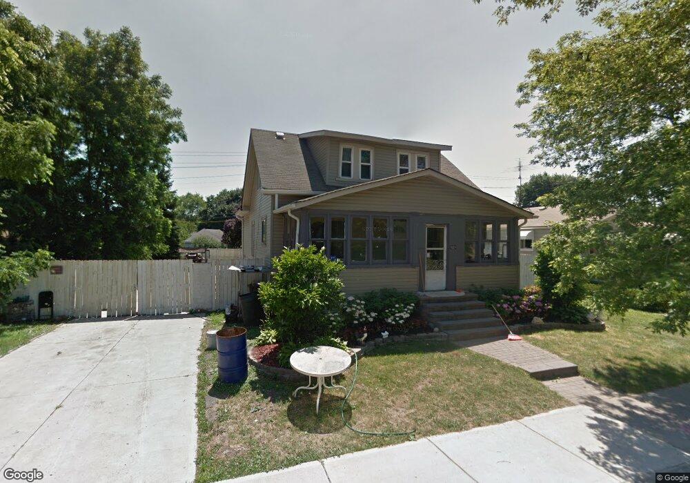
1021 Pennsylvania Ave Lincoln Park, MI 48146
Estimated Value: $153,000 - $228,000
--
Bed
1
Bath
1,248
Sq Ft
$152/Sq Ft
Est. Value
About This Home
This home is located at 1021 Pennsylvania Ave, Lincoln Park, MI 48146 and is currently estimated at $190,112, approximately $152 per square foot. 1021 Pennsylvania Ave is a home located in Wayne County with nearby schools including Lafayette School, Lincoln Park Middle School, and Lincoln Park High School.
Ownership History
Date
Name
Owned For
Owner Type
Purchase Details
Closed on
Oct 23, 2006
Sold by
Spradlin Carol
Bought by
Gonzales Dario
Current Estimated Value
Purchase Details
Closed on
Nov 2, 2005
Sold by
Smith Jimmy W and Smith Heather R
Bought by
National City Bank Of Kentucky
Purchase Details
Closed on
Dec 23, 2003
Sold by
Pomaville Raymond J and Pomaville Jean L
Bought by
Smith Jimmy W
Purchase Details
Closed on
Dec 8, 2003
Sold by
Pomaville Paul A and Pomaville Catherine
Bought by
Pomaville Raymond
Create a Home Valuation Report for This Property
The Home Valuation Report is an in-depth analysis detailing your home's value as well as a comparison with similar homes in the area
Home Values in the Area
Average Home Value in this Area
Purchase History
| Date | Buyer | Sale Price | Title Company |
|---|---|---|---|
| Gonzales Dario | $50,000 | None Available | |
| National City Bank Of Kentucky | $65,495 | None Available | |
| Smith Jimmy W | $100,000 | Metropolitan Title Company | |
| Pomaville Raymond | -- | Metropolitan Title Company |
Source: Public Records
Tax History Compared to Growth
Tax History
| Year | Tax Paid | Tax Assessment Tax Assessment Total Assessment is a certain percentage of the fair market value that is determined by local assessors to be the total taxable value of land and additions on the property. | Land | Improvement |
|---|---|---|---|---|
| 2025 | $1,526 | $129,100 | $0 | $0 |
| 2024 | $1,526 | $103,100 | $0 | $0 |
| 2023 | $1,447 | $93,400 | $0 | $0 |
| 2022 | $1,710 | $81,300 | $0 | $0 |
| 2021 | $1,674 | $76,000 | $0 | $0 |
| 2020 | $1,659 | $57,500 | $0 | $0 |
| 2019 | $1,311 | $42,500 | $0 | $0 |
| 2018 | $1,181 | $29,300 | $0 | $0 |
| 2017 | $845 | $28,700 | $0 | $0 |
| 2016 | $1,494 | $28,200 | $0 | $0 |
| 2015 | $2,760 | $27,600 | $0 | $0 |
| 2013 | $2,930 | $30,700 | $0 | $0 |
| 2012 | $1,818 | $31,600 | $6,300 | $25,300 |
Source: Public Records
Map
Nearby Homes
- 1523 Reo Ave
- 1587 Reo Ave
- 1458 Cicotte Ave
- 1267 Fort Park Blvd
- 1424 Cicotte Ave
- 1463 Cicotte Ave
- 3550 S Edsel St
- 1383 Cicotte Ave
- 1826 Morris Ave
- 26165 W Outer Dr
- 1862 Montie Rd
- 1426 Keppen Blvd
- 1563 Russell Ave
- 1532 Euclid St
- 1929 Paris Ave
- 1382 Euclid St
- 2064 Morris Ave
- 3422 S Annabelle St
- 19120 Dix Rd
- 1921 Hanford Ave
- 1031 Pennsylvania Ave
- 1520 Montie Rd
- 1055 Pennsylvania Ave
- 1533 Montie Rd
- 1056 Pennsylvania Ave
- 1060 Pennsylvania Ave
- 1063 Pennsylvania Ave
- 1064 Pennsylvania Ave
- 1000 Lafayette Blvd
- 1066 Pennsylvania Ave
- 1523 Montie Rd
- 1506 Montie Rd
- 1008 Lafayette Blvd
- 1067 Pennsylvania Ave
- 1505 Montie Rd
- 1068 Pennsylvania Ave
- 1517 Montie Rd
- 1071 Pennsylvania Ave
- 966 Lafayette Blvd
- 1072 Pennsylvania Ave