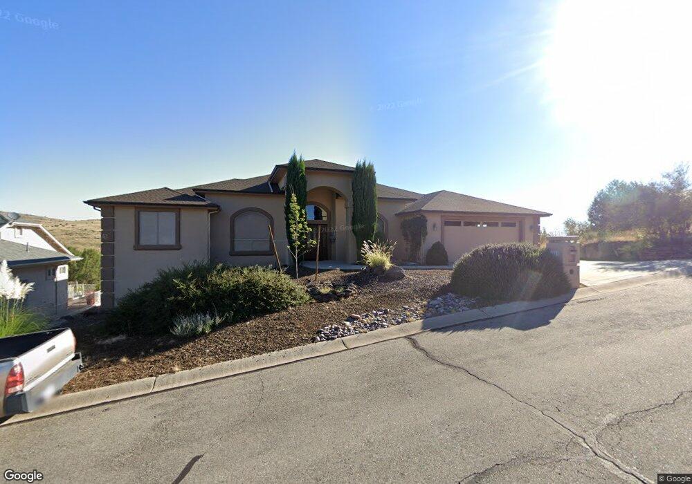
1021 Rough Diamond Dr Prescott, AZ 86301
Yavapai Hills NeighborhoodEstimated Value: $819,497 - $932,000
--
Bed
--
Bath
2,730
Sq Ft
$317/Sq Ft
Est. Value
About This Home
This home is located at 1021 Rough Diamond Dr, Prescott, AZ 86301 and is currently estimated at $864,124, approximately $316 per square foot. 1021 Rough Diamond Dr is a home located in Yavapai County with nearby schools including Taylor Hicks School, Granite Mountain Middle School, and Prescott Mile High Middle School.
Ownership History
Date
Name
Owned For
Owner Type
Purchase Details
Closed on
Dec 10, 2012
Sold by
Batchelor Family Trust and Batchelor Richard L
Bought by
Batchelor Richard L and Batchelor Elisabeth B
Current Estimated Value
Home Financials for this Owner
Home Financials are based on the most recent Mortgage that was taken out on this home.
Original Mortgage
$135,000
Outstanding Balance
$23,763
Interest Rate
2.61%
Mortgage Type
New Conventional
Estimated Equity
$840,361
Purchase Details
Closed on
Nov 10, 2005
Sold by
Batchelor Richard L and Batchelor Elisabeth B
Bought by
Batchelor Richard L and Batchelor Elisabeth B
Purchase Details
Closed on
Oct 26, 1999
Sold by
First Amer Title Ins Agency Yavapai Inc
Bought by
Batchelor Richard L and Batchelor Elisabeth B
Create a Home Valuation Report for This Property
The Home Valuation Report is an in-depth analysis detailing your home's value as well as a comparison with similar homes in the area
Home Values in the Area
Average Home Value in this Area
Purchase History
| Date | Buyer | Sale Price | Title Company |
|---|---|---|---|
| Batchelor Richard L | -- | Boston National Title | |
| Bachelor Family Trust | -- | None Available | |
| Batchelor Richard L | -- | None Available | |
| Batchelor Richard L | $63,180 | First American Title |
Source: Public Records
Mortgage History
| Date | Status | Borrower | Loan Amount |
|---|---|---|---|
| Open | Batchelor Richard L | $135,000 |
Source: Public Records
Tax History Compared to Growth
Tax History
| Year | Tax Paid | Tax Assessment Tax Assessment Total Assessment is a certain percentage of the fair market value that is determined by local assessors to be the total taxable value of land and additions on the property. | Land | Improvement |
|---|---|---|---|---|
| 2026 | $2,717 | $75,956 | -- | -- |
| 2024 | $2,610 | $76,700 | -- | -- |
| 2023 | $2,649 | $61,864 | $9,038 | $52,826 |
| 2022 | $2,610 | $54,025 | $6,712 | $47,313 |
| 2021 | $2,800 | $54,356 | $6,016 | $48,340 |
| 2020 | $2,813 | $0 | $0 | $0 |
| 2019 | $2,793 | $0 | $0 | $0 |
| 2018 | $2,668 | $0 | $0 | $0 |
| 2017 | $2,572 | $0 | $0 | $0 |
| 2016 | $2,561 | $0 | $0 | $0 |
| 2015 | $2,483 | $0 | $0 | $0 |
| 2014 | $2,476 | $0 | $0 | $0 |
Source: Public Records
Map
Nearby Homes
- 1037 Trouble Shooter Ln
- 4600 Prairie Trail
- 1025 Picket Ct
- 942 Rough Diamond Dr Unit 90
- 942 Rough Diamond Dr
- 4751 Sharp Shooter Way
- 4643 Sharp Shooter Way
- 1014 Yavapai Hills Dr
- 880 Bonanza Trail
- 4429 Hornet Dr
- 1047 Yavapai Hills Dr
- 1154 Sunrise Blvd
- 1158 Sunrise Blvd
- 1144 Sunrise Blvd
- 1148 Sunrise Blvd
- 1162 Sunrise Blvd
- 1170 Sunrise Blvd
- 1166 Sunrise Blvd
- 1136 Sunrise Blvd
- 4456 Hornet Dr
- 1027 Rough Diamond Dr
- 4581 Prairie Trail
- 4589 Prairie Trail
- 4565 Prairie Trail
- 1009 Rough Diamond Dr
- 1018 Rough Diamond Dr
- 4597 Prairie Trail
- 88 Rough Diamond Dr
- 86 Rough Diamond Dr
- 5 Rough Diamond Dr
- 6 Rough Diamond Dr
- 10 Rough Diamond Dr
- 14 Rough Diamond Dr
- 75 Rough Diamond Dr
- 81 Rough Diamond Dr
- 84 Rough Diamond Dr
- 78 Rough Diamond Dr
- 0 Rough Diamond Dr
- 79 Rough Diamond Dr
- 15 Rough Diamond Dr