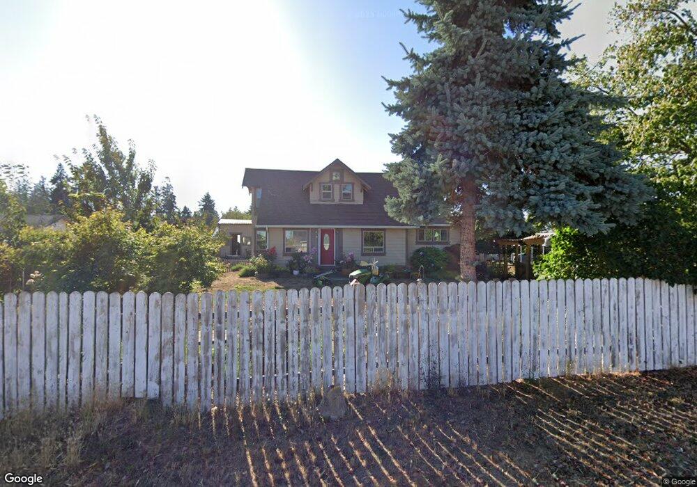
1021 S 7th Ave Sequim, WA 98382
Estimated Value: $338,000 - $392,460
3
Beds
2
Baths
1,016
Sq Ft
$367/Sq Ft
Est. Value
About This Home
This home is located at 1021 S 7th Ave, Sequim, WA 98382 and is currently estimated at $372,487, approximately $366 per square foot. 1021 S 7th Ave is a home located in Clallam County with nearby schools including Greywolf Elementary School, Sequim Middle School, and Sequim Senior High School.
Ownership History
Date
Name
Owned For
Owner Type
Purchase Details
Closed on
Mar 24, 2020
Sold by
Rogers Richard Linn
Bought by
Rogers Richard Linn and Rogers Dung Than
Current Estimated Value
Home Financials for this Owner
Home Financials are based on the most recent Mortgage that was taken out on this home.
Original Mortgage
$112,000
Interest Rate
3.4%
Mortgage Type
New Conventional
Create a Home Valuation Report for This Property
The Home Valuation Report is an in-depth analysis detailing your home's value as well as a comparison with similar homes in the area
Purchase History
| Date | Buyer | Sale Price | Title Company |
|---|---|---|---|
| Rogers Richard Linn | -- | Clallam Title Company |
Source: Public Records
Mortgage History
| Date | Status | Borrower | Loan Amount |
|---|---|---|---|
| Closed | Rogers Richard Linn | $112,000 |
Source: Public Records
Tax History
| Year | Tax Paid | Tax Assessment Tax Assessment Total Assessment is a certain percentage of the fair market value that is determined by local assessors to be the total taxable value of land and additions on the property. | Land | Improvement |
|---|---|---|---|---|
| 2025 | $2,553 | $340,465 | $64,421 | $276,044 |
| 2023 | $2,553 | $338,088 | $64,421 | $273,667 |
| 2022 | $2,558 | $327,222 | $53,555 | $273,667 |
| 2021 | $2,193 | $234,480 | $38,808 | $195,672 |
| 2020 | $2,267 | $234,480 | $38,808 | $195,672 |
| 2018 | $1,915 | $189,138 | $38,808 | $150,330 |
| 2017 | $945 | $170,178 | $38,808 | $131,370 |
| 2016 | $1,445 | $170,364 | $38,808 | $131,556 |
| 2015 | $1,382 | $132,037 | $38,808 | $93,229 |
| 2013 | $1,382 | $120,708 | $43,344 | $77,364 |
| 2012 | $1,382 | $136,345 | $50,400 | $85,945 |
Source: Public Records
Map
Nearby Homes
- Ridgefield Plan at Rolling Hills
- Benton Plan at Rolling Hills
- Hamilton Plan at Rolling Hills
- Richland Plan at Rolling Hills
- Creston Plan at Rolling Hills
- 4 Gillis Ave
- 653 Gooseberry Place
- 9999 S 7th Ave
- 642 Gooseberry Place
- 637 Gooseberry Place
- 634 Gooseberry Place
- 626 Gooseberry Place
- 621 Gooseberry Place
- 618 Gooseberry Place
- 1033 Royal Velvet Dr
- 601 Sunbeam Place
- 592 Silver Frost Dr
- 1024 Royal Velvet Dr
- 579 Silver Frost Dr
- 542 Silver Frost Dr
- 1342 S 7th Ave
- 961 S 7th Ave Unit 931
- 42 Gillis Ave
- 999 Eleventh Ct
- 1085 Folgate Dr Unit 36169488
- 10 Gillis Ave Unit 22 & 24 Daisy Lane
- 999 S 7th Ave
- 999 S 7th Ave Unit Phase II
- 0000 Gillis Ave
- 0 Gillis Ave
- 31 Daisy Ln
- 999 PalMcO Way Lot #7
- 9999 S Seventh Ave
- 9999 S 7th Ave Unit Sequim WA 98382
- 901 S 7th Ave
- 31 Gillis Ave
- 0 Olympic Haven St Unit 36113074
- 0 Olympic Haven St Unit 36113050
- 111 Gillis Ave
- 631 Silver Frost Dr
Your Personal Tour Guide
Ask me questions while you tour the home.