
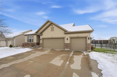
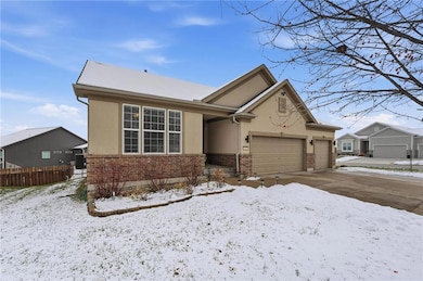
1021 SW Cheshire Dr Raymore, MO 64083
Estimated payment $2,883/month
Highlights
- Very Popular Property
- Traditional Architecture
- Main Floor Bedroom
- Deck
- Wood Flooring
- Community Pool
About This Home
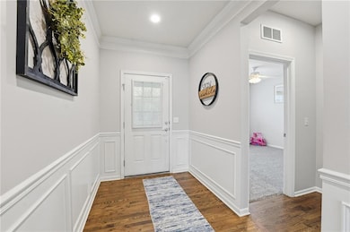
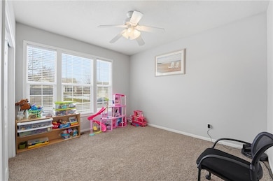
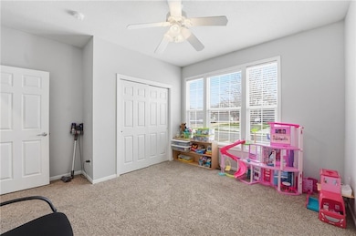
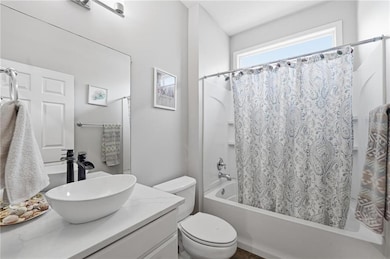
Updated & upgraded true ranch with over 1800 sqft on main level! Finished walkout LL has 1100 sqft finished & large unfinished storage space. Wood floor from entry through dining, living, kitchen, breakfast & primary suite. Fireplace has stone floor to ceiling, with wood mantle. Kitchen has custom cabinets, updated tile backsplash, granite counters & upgraded s/s appliances! 2 dining areas, formal dining offers space for large table & additional cabinet or storage piece, breakfast room is surrounded by large windows and door out to expanded deck, with stairs down to patio & great backyard with black metal fence. Large laundry room off kitchen. Primary suite has huge walk-in closet, private bath with granite dbl vanity w/ vessel sinks, large tiled shower. 2 additional bedrooms share hall bath. Lower level family room offers tons of space for media, games, workout space. 2 large bedrooms & bathroom with shower. Great storage space remains, great for workshop as well. Door out to patio and backyard. Garage is 30' wide and all 3 bays are 22' deep! Engineered floor joists.
Listing Agent
ReeceNichols - Lees Summit Brokerage Phone: 816-679-8336 License #1999099326 Listed on: 12/04/2025

Home Details
Home Type
- Single Family
Est. Annual Taxes
- $4,081
Year Built
- Built in 2007
Lot Details
- 9,453 Sq Ft Lot
- Aluminum or Metal Fence
- Paved or Partially Paved Lot
HOA Fees
- $52 Monthly HOA Fees
Parking
- 3 Car Attached Garage
- Front Facing Garage
- Garage Door Opener
Home Design
- Traditional Architecture
- Composition Roof
- Vinyl Siding
- Stucco
Interior Spaces
- Ceiling Fan
- Gas Fireplace
- Thermal Windows
- Entryway
- Great Room with Fireplace
- Family Room
- Living Room
- Formal Dining Room
- Workshop
- Fire and Smoke Detector
Kitchen
- Breakfast Room
- Dishwasher
- Disposal
Flooring
- Wood
- Carpet
- Ceramic Tile
Bedrooms and Bathrooms
- 5 Bedrooms
- Main Floor Bedroom
- Walk-In Closet
- 3 Full Bathrooms
Laundry
- Laundry Room
- Laundry on main level
Finished Basement
- Basement Fills Entire Space Under The House
- Sump Pump
- Bedroom in Basement
Schools
- Timber Creek Elementary School
- Raymore-Peculiar High School
Additional Features
- Deck
- City Lot
- Forced Air Heating and Cooling System
Listing and Financial Details
- Assessor Parcel Number 8900052
- $0 special tax assessment
Community Details
Overview
- Association fees include curbside recycling, trash
- Community Association Management Association
- Kensington Farms Subdivision
Recreation
- Community Pool
Map
Home Values in the Area
Average Home Value in this Area
Tax History
| Year | Tax Paid | Tax Assessment Tax Assessment Total Assessment is a certain percentage of the fair market value that is determined by local assessors to be the total taxable value of land and additions on the property. | Land | Improvement |
|---|---|---|---|---|
| 2025 | $4,079 | $55,480 | $6,920 | $48,560 |
| 2024 | $4,079 | $48,560 | $6,290 | $42,270 |
| 2023 | $4,066 | $48,560 | $6,290 | $42,270 |
| 2022 | $3,777 | $43,200 | $6,290 | $36,910 |
| 2021 | $3,777 | $43,200 | $6,290 | $36,910 |
| 2020 | $3,794 | $42,460 | $6,290 | $36,170 |
| 2019 | $3,727 | $42,460 | $6,290 | $36,170 |
| 2018 | $3,528 | $37,900 | $5,300 | $32,600 |
| 2017 | $3,294 | $37,900 | $5,300 | $32,600 |
| 2016 | $3,294 | $36,140 | $5,300 | $30,840 |
| 2015 | $3,293 | $36,140 | $5,300 | $30,840 |
| 2014 | $3,306 | $36,140 | $5,300 | $30,840 |
| 2013 | -- | $36,140 | $5,300 | $30,840 |
Property History
| Date | Event | Price | List to Sale | Price per Sq Ft |
|---|---|---|---|---|
| 12/04/2025 12/04/25 | For Sale | $475,000 | -- | $161 / Sq Ft |
Purchase History
| Date | Type | Sale Price | Title Company |
|---|---|---|---|
| Corporate Deed | -- | -- |
Mortgage History
| Date | Status | Loan Amount | Loan Type |
|---|---|---|---|
| Open | $229,900 | New Conventional |
Source: Heartland MLS
MLS Number: 2590009
APN: 8900052
Disclaimer: Certain information contained herein is derived from information provided by parties other than Homes.com. All information provided is deemed reliable, but is not guaranteed to be accurate and should be independently verified.
![]() Based on information submitted to the MLS GRID as of [see last changed date above]. All data is obtained from various sources and may not have been verified by broker or MLS GRID. Supplied Open House Information is subject to change without notice. All information should be independently reviewed and verified for accuracy. Properties may or may not be listed by the office/agent presenting the information. Some IDX listings have been excluded from this website. Prices displayed on all Sold listings are the Last Known Listing Price and may not be the actual selling price.
Based on information submitted to the MLS GRID as of [see last changed date above]. All data is obtained from various sources and may not have been verified by broker or MLS GRID. Supplied Open House Information is subject to change without notice. All information should be independently reviewed and verified for accuracy. Properties may or may not be listed by the office/agent presenting the information. Some IDX listings have been excluded from this website. Prices displayed on all Sold listings are the Last Known Listing Price and may not be the actual selling price.
Listing Information presented by local MLS brokerage: TEN-X, INC., local REALTOR®- Arlene Richardson - (888)952-6393
The Digital Millennium Copyright Act of 1998, 17 U.S.C. § 512 (the “DMCA”) provides recourse for copyright owners who believe that material appearing on the Internet infringes their rights under U.S. copyright law. If you believe in good faith that any content or material made available in connection with our website or services infringes your copyright, you (or your agent) may send us a notice requesting that the content or material be removed, or access to it blocked.
Notices must be sent in writing by email to DMCAnotice@MLSGrid.com.
The DMCA requires that your notice of alleged copyright infringement include the following information:
(1) description of the copyrighted work that is the subject of claimed infringement;
(2) description of the alleged infringing content and information sufficient to permit us to locate the content;
(3) contact information for you, including your address, telephone number and email address;
(4) a statement by you that you have a good faith belief that the content in the manner complained of is not authorized by the copyright owner, or its agent, or by the operation of any law;
(5) a statement by you, signed under penalty of perjury, that the information in the notification is accurate and that you have the authority to enforce the copyrights that are claimed to be infringed; and
(6) a physical or electronic signature of the copyright owner or a person authorized to act on the copyright owner’s behalf. Failure to include all of the above information may result in the delay of the processing of your complaint.
- 1022 SW Cheshire Dr
- 4520 SW Berkshire Dr
- 4528 SW Berkshire Dr
- 4624 SW Robinson Dr
- 4605 SW Olympia Cir
- 4628 SW Robinson Dr
- 4510 SW Fenwick Rd
- 1100 SW Blackpool Dr
- 4647 SW Olympia Place
- 4641 SW Soldier Dr
- 4400 SW Rivulet Dr
- 917 SW Soldier Ct
- 4600 SW Admiral Byrd Dr
- 1128 SW Whitby Dr
- 1132 SW Whitby Dr
- 1136 SW Whitby Dr
- Cambridge Plan at Kensington Farms - Kennsington Farms
- Sonoma Plan at Kensington Farms - Kennsington Farms
- Danbury Plan at Kensington Farms - Kennsington Farms
- Fairfield Expanded Plan at Kensington Farms - Kennsington Farms
- 4435 SW Creekview Dr
- 3925 SW Granite Ln
- 3904 SW Brian Ln
- 4050 SW La Harve Dr
- 4050 SW Laharve Dr
- 3545 SW Harbor Dr
- 700 SW Lemans Ln
- 1318 SW Manor Lake Dr
- 3906 SW Chartwell Ct
- 3735 SW Knoxville Ct
- 3500 SW Hollywood Dr
- 3545 SE Corbin Dr
- 1400 Cottonwood Dr
- 2300 SW Stone Bridge Ct
- 607 Hamblen Rd
- 2231-2237 SW Burning Wood Ln
- 328 Shenandoah Dr
- 420 Buffalo Ct
- 421 Sunflower Dr
- 410 W Heritage Dr