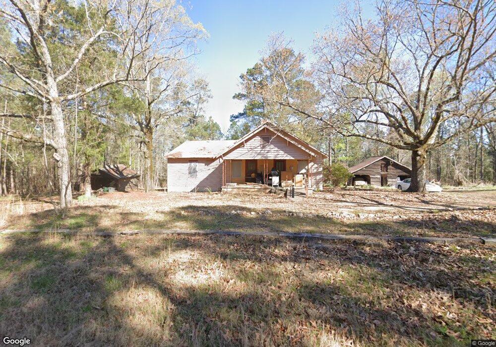
1021 Twins Rd Greensboro, GA 30642
Estimated Value: $86,000 - $118,533
--
Bed
2
Baths
1,454
Sq Ft
$65/Sq Ft
Est. Value
About This Home
This home is located at 1021 Twins Rd, Greensboro, GA 30642 and is currently estimated at $94,633, approximately $65 per square foot. 1021 Twins Rd is a home located in Greene County with nearby schools including Greene County High School.
Ownership History
Date
Name
Owned For
Owner Type
Purchase Details
Closed on
Jul 2, 2025
Sold by
Leach Billy K
Bought by
Pratt Erra
Current Estimated Value
Purchase Details
Closed on
Feb 4, 2003
Sold by
Leach Leora--Also See
Bought by
Leach Leora
Purchase Details
Closed on
Nov 24, 1999
Sold by
Leach R L Etal
Bought by
Leach Leora--Also See
Purchase Details
Closed on
Jan 1, 1986
Sold by
Leach R L Etal
Bought by
Leach R L Etal
Purchase Details
Closed on
Jan 1, 1980
Sold by
Leach J W
Bought by
Leach R L Etal
Purchase Details
Closed on
Jan 1, 1952
Bought by
Leach J W
Create a Home Valuation Report for This Property
The Home Valuation Report is an in-depth analysis detailing your home's value as well as a comparison with similar homes in the area
Home Values in the Area
Average Home Value in this Area
Purchase History
| Date | Buyer | Sale Price | Title Company |
|---|---|---|---|
| Pratt Erra | $85,000 | -- | |
| Pratt Erra | -- | -- | |
| Leach Leora | -- | -- | |
| Leach Leora--Also See | -- | -- | |
| Leach R L Etal | -- | -- | |
| Leach R L Etal | -- | -- | |
| Leach J W | -- | -- |
Source: Public Records
Tax History Compared to Growth
Tax History
| Year | Tax Paid | Tax Assessment Tax Assessment Total Assessment is a certain percentage of the fair market value that is determined by local assessors to be the total taxable value of land and additions on the property. | Land | Improvement |
|---|---|---|---|---|
| 2025 | $744 | $33,560 | $12,160 | $21,400 |
| 2024 | $747 | $32,080 | $12,160 | $19,920 |
| 2023 | $658 | $27,000 | $7,840 | $19,160 |
| 2022 | $485 | $17,480 | $7,840 | $9,640 |
| 2021 | $481 | $16,440 | $7,840 | $8,600 |
| 2020 | $418 | $12,160 | $5,160 | $7,000 |
| 2019 | $424 | $12,160 | $5,160 | $7,000 |
| 2018 | $144 | $12,160 | $5,160 | $7,000 |
| 2017 | $144 | $12,169 | $5,165 | $7,004 |
| 2016 | $146 | $12,471 | $5,165 | $7,306 |
| 2015 | $120 | $12,471 | $5,165 | $7,306 |
| 2014 | $118 | $12,225 | $5,165 | $7,060 |
Source: Public Records
Map
Nearby Homes
- 1991 Armour Bridge Rd
- 1800 Buckhead Dr
- 1000 Tree A Coon Place
- 1031 Hawks Bill Dr
- 1113 Wharfside Ct
- 1430 Buckhead Dr
- 1107 Wharfside Ct
- 1131 Fleur de Lac Ln
- 1651 Lighthouse Cir
- 2660 Club Dr
- 1001 Shoal Creek Ct
- 1041 Shadow Creek Way
- 2390 Club Dr
- 1230 Westchester
- 2541 Club Dr
- 1251 Lake Club Dr
- 2691 Club Dr
- 1411 Lighthouse Cir
- 1401 Lighthouse Cir
- 1020 Portage Trail
- 1020 Granite Cove Dr
- 1041 Granite Cove Dr
- 1070 Granite Cove Dr
- 1070 Granite Cove Dr Unit 1070 Granite Cove Dr
- 1071 Granite Cove Dr
- 4691 Walker Church Rd
- 1010 Armour Bridge Rd
- 1091 Split Rock Dr
- 1151 Split Rock Dr
- 1140 Split Rock Dr
- 1945 Eagle Way
- 1121 Granite Cove Dr
- 1030 Armour Bridge Rd
- 1120 Granite Cove Dr
- 1040 Armour Bridge Rd
- 1160 Granite Cove Dr
- 1110 A P Roper Rd
- 1201 Granite Cove Dr
- 1210 Armour Bridge Rd
- 1210 Granite Cove Dr