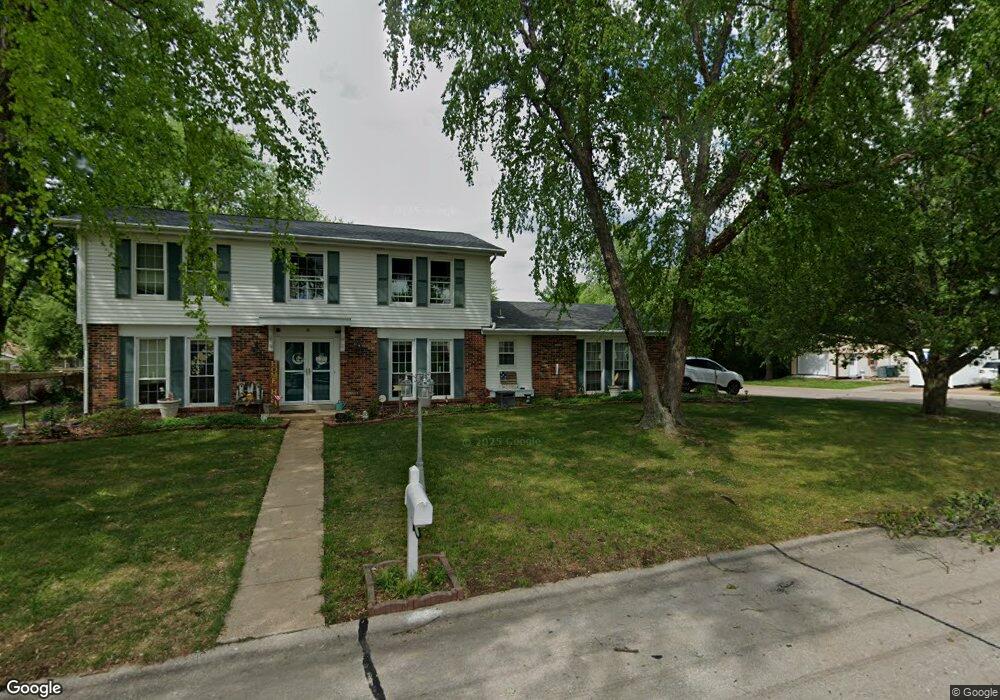
1021 Vicksburg Dr Belleville, IL 62221
Estimated Value: $181,000 - $228,717
--
Bed
--
Bath
1,026
Sq Ft
$205/Sq Ft
Est. Value
About This Home
This home is located at 1021 Vicksburg Dr, Belleville, IL 62221 and is currently estimated at $209,929, approximately $204 per square foot. 1021 Vicksburg Dr is a home located in St. Clair County with nearby schools including Belle Valley Elementary School-North, Zion Lutheran School Belleville, and St Teresa Catholic School.
Ownership History
Date
Name
Owned For
Owner Type
Purchase Details
Closed on
Mar 8, 2006
Sold by
Justis John and Justis Gail L
Bought by
Green Sean and Green Nicole
Current Estimated Value
Home Financials for this Owner
Home Financials are based on the most recent Mortgage that was taken out on this home.
Original Mortgage
$155,000
Outstanding Balance
$87,858
Interest Rate
6.22%
Mortgage Type
VA
Estimated Equity
$122,071
Create a Home Valuation Report for This Property
The Home Valuation Report is an in-depth analysis detailing your home's value as well as a comparison with similar homes in the area
Home Values in the Area
Average Home Value in this Area
Purchase History
| Date | Buyer | Sale Price | Title Company |
|---|---|---|---|
| Green Sean | $155,000 | Fatic |
Source: Public Records
Mortgage History
| Date | Status | Borrower | Loan Amount |
|---|---|---|---|
| Open | Green Sean | $155,000 |
Source: Public Records
Tax History Compared to Growth
Tax History
| Year | Tax Paid | Tax Assessment Tax Assessment Total Assessment is a certain percentage of the fair market value that is determined by local assessors to be the total taxable value of land and additions on the property. | Land | Improvement |
|---|---|---|---|---|
| 2024 | -- | $54,577 | $8,151 | $46,426 |
| 2023 | -- | $53,377 | $8,037 | $45,340 |
| 2022 | $0 | $48,613 | $7,320 | $41,293 |
| 2021 | $0 | $46,618 | $7,020 | $39,598 |
| 2020 | $2,739 | $43,414 | $6,537 | $36,877 |
| 2019 | $2,739 | $41,441 | $6,671 | $34,770 |
| 2018 | $0 | $40,383 | $6,501 | $33,882 |
| 2017 | $0 | $39,308 | $6,328 | $32,980 |
| 2016 | $0 | $37,953 | $6,110 | $31,843 |
| 2014 | $2,799 | $39,617 | $7,193 | $32,424 |
| 2013 | $4,632 | $39,617 | $7,193 | $32,424 |
Source: Public Records
Map
Nearby Homes
- 405 Todd Ln
- 747 Farragut Ct
- 372 Roanoke Dr
- 1420 Vicksburg Dr
- 0 Denvershire Dr
- 3313 Denvershire Dr
- 2077 Camrose Green St
- 2073 Camrose Green St
- 3300 Berwin Green Dr
- 300 Todd Ln
- 2069 Camrose Green St
- 2065 Camrose Green St
- 2061 Camrose Green St
- 3304 Berwin Green Dr
- 2057 Camrose Green St
- 2053 Camrose Green St
- 2049 Camrose Green St
- 2021 Camrose Green St
- 340 Roanoke Dr
- 2017 Camrose Green St
- 413 Harpers Ferry Rd
- 413 Harpers Ferry Dr
- 1017 Vicksburg Dr
- 412 Bull Run Rd
- 1020 Vicksburg Dr
- 409 Harpers Ferry Dr
- 1029 Vicksburg Dr
- 1024 Vicksburg Dr
- 1016 Vicksburg Dr
- 412 Harpers Ferry Dr
- 408 Bull Run Rd
- 1028 Vicksburg Dr
- 1012 Vicksburg Dr
- 408 Harpers Ferry Dr
- 408 Harpers Ferry Rd
- 405 Harpers Ferry Dr
- 1032 Vicksburg Dr
- 404 Bull Run Rd
- 425 Stone River Rd
- 417 Bull Run Rd