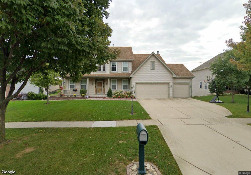
1022 Hodge Ln Batavia, IL 60510
Southeast Batavia NeighborhoodEstimated Value: $525,192 - $623,000
4
Beds
--
Bath
2,796
Sq Ft
$212/Sq Ft
Est. Value
About This Home
This home is located at 1022 Hodge Ln, Batavia, IL 60510 and is currently estimated at $593,048, approximately $212 per square foot. 1022 Hodge Ln is a home located in Kane County with nearby schools including J B Nelson Elementary School, Sam Rotolo Middle School, and Batavia Sr High School.
Ownership History
Date
Name
Owned For
Owner Type
Purchase Details
Closed on
Nov 10, 2004
Sold by
Whitty Christina M and Murdock Christina M
Bought by
Whitty Christina M
Current Estimated Value
Home Financials for this Owner
Home Financials are based on the most recent Mortgage that was taken out on this home.
Original Mortgage
$100,000
Outstanding Balance
$49,970
Interest Rate
5.8%
Mortgage Type
Credit Line Revolving
Estimated Equity
$543,078
Purchase Details
Closed on
Oct 8, 2003
Sold by
Murdock Michael G
Bought by
Murdock Christina M
Purchase Details
Closed on
Feb 22, 2001
Sold by
Dh Davey Farm Inc
Bought by
Murdock Michael G and Murdock Christina M
Home Financials for this Owner
Home Financials are based on the most recent Mortgage that was taken out on this home.
Original Mortgage
$210,000
Outstanding Balance
$76,422
Interest Rate
7.18%
Estimated Equity
$516,626
Create a Home Valuation Report for This Property
The Home Valuation Report is an in-depth analysis detailing your home's value as well as a comparison with similar homes in the area
Home Values in the Area
Average Home Value in this Area
Purchase History
| Date | Buyer | Sale Price | Title Company |
|---|---|---|---|
| Whitty Christina M | -- | -- | |
| Murdock Christina M | -- | -- | |
| Murdock Michael G | $334,500 | Stewart Title |
Source: Public Records
Mortgage History
| Date | Status | Borrower | Loan Amount |
|---|---|---|---|
| Open | Whitty Christina M | $100,000 | |
| Open | Murdock Michael G | $210,000 |
Source: Public Records
Tax History
| Year | Tax Paid | Tax Assessment Tax Assessment Total Assessment is a certain percentage of the fair market value that is determined by local assessors to be the total taxable value of land and additions on the property. | Land | Improvement |
|---|---|---|---|---|
| 2024 | $10,667 | $142,911 | $24,813 | $118,098 |
| 2023 | $10,443 | $129,706 | $22,520 | $107,186 |
| 2022 | $10,061 | $121,221 | $21,047 | $100,174 |
| 2021 | $10,595 | $125,523 | $19,961 | $105,562 |
| 2020 | $10,335 | $123,110 | $19,577 | $103,533 |
| 2019 | $10,743 | $125,127 | $18,884 | $106,243 |
| 2018 | $10,604 | $123,522 | $18,165 | $105,357 |
| 2017 | $10,350 | $119,449 | $17,566 | $101,883 |
| 2016 | $10,133 | $115,970 | $17,054 | $98,916 |
| 2015 | -- | $113,330 | $16,666 | $96,664 |
| 2014 | -- | $109,762 | $16,141 | $93,621 |
| 2013 | -- | $117,738 | $25,944 | $91,794 |
Source: Public Records
Map
Nearby Homes
- 1136 Pine Ct
- 1220 Davey Dr
- 694 Hart Rd
- 701 Viking Dr
- 1206 Beckman Ln
- Lot 4 Manchester Ave
- 1012 Edwards Dr
- 860 S River St
- 570 Violet Ln
- 304 S Prairie St
- 414 Cleveland Ave
- 1402 Cherry Dr
- Lot 1 Center St
- 121 S Raddant Rd
- 637 E Wilson St
- 527 Ridgelawn Trail
- 1025 E Wilson St
- 1816 Burnell Ct
- 1705 South Ct
- 1687 Sauk Dr
Your Personal Tour Guide
Ask me questions while you tour the home.