Estimated Value: $97,246 - $151,000
4
Beds
1
Bath
1,550
Sq Ft
$79/Sq Ft
Est. Value
About This Home
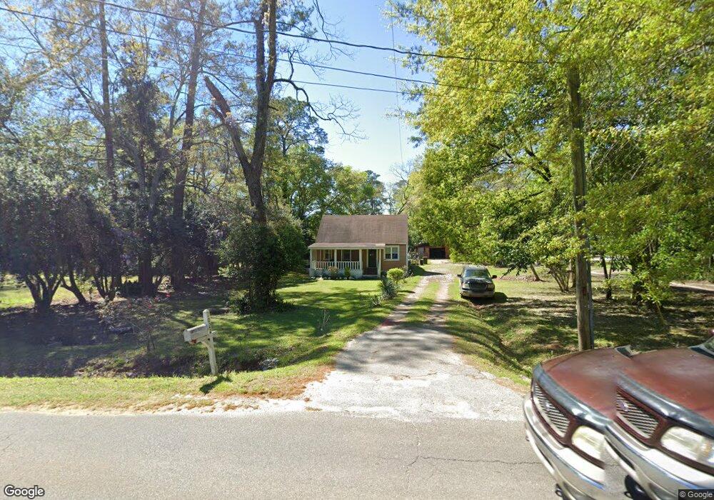
This home is located at 1022 S Broad St, Cairo, GA 39828 and is currently estimated at $122,562, approximately $79 per square foot. 1022 S Broad St is a home located in Grady County with nearby schools including Cairo High School.
Ownership History
Date
Name
Owned For
Owner Type
Purchase Details
Closed on
Jul 1, 2010
Sold by
Jeffery Jeffry J
Bought by
Adams Cecil
Current Estimated Value
Home Financials for this Owner
Home Financials are based on the most recent Mortgage that was taken out on this home.
Original Mortgage
$72,000
Outstanding Balance
$51,010
Interest Rate
4.79%
Mortgage Type
USDA
Estimated Equity
$71,552
Purchase Details
Closed on
May 18, 2009
Sold by
Flowers Billy F
Bought by
Jeffery Jeffrey J
Purchase Details
Closed on
Feb 2, 2005
Sold by
Jones Carl James
Bought by
Flowers Billy F and Flowers Mary E
Purchase Details
Closed on
Nov 5, 2001
Sold by
Barrs Gary A
Bought by
Jones Carl Jackson
Purchase Details
Closed on
Dec 1, 1993
Bought by
Barrs Gary A
Create a Home Valuation Report for This Property
The Home Valuation Report is an in-depth analysis detailing your home's value as well as a comparison with similar homes in the area
Purchase History
| Date | Buyer | Sale Price | Title Company |
|---|---|---|---|
| Adams Cecil | $66,000 | -- | |
| Jeffery Jeffrey J | $25,000 | -- | |
| Flowers Billy F | -- | -- | |
| Jones Carl Jackson | $35,000 | -- | |
| Barrs Gary A | $48,000 | -- |
Source: Public Records
Mortgage History
| Date | Status | Borrower | Loan Amount |
|---|---|---|---|
| Open | Adams Cecil | $72,000 |
Source: Public Records
Tax History
| Year | Tax Paid | Tax Assessment Tax Assessment Total Assessment is a certain percentage of the fair market value that is determined by local assessors to be the total taxable value of land and additions on the property. | Land | Improvement |
|---|---|---|---|---|
| 2025 | $891 | $33,928 | $2,700 | $31,228 |
| 2024 | $891 | $31,222 | $2,700 | $28,522 |
| 2023 | $972 | $27,924 | $4,978 | $22,946 |
| 2022 | $1,014 | $27,924 | $4,978 | $22,946 |
| 2021 | $1,016 | $27,924 | $4,978 | $22,946 |
| 2020 | $1,019 | $27,924 | $4,978 | $22,946 |
| 2019 | $1,019 | $27,924 | $4,978 | $22,946 |
| 2018 | $969 | $27,924 | $4,978 | $22,946 |
| 2017 | $933 | $27,924 | $4,978 | $22,946 |
| 2016 | $835 | $24,629 | $4,978 | $19,650 |
| 2015 | $827 | $24,629 | $4,978 | $19,650 |
| 2014 | $827 | $24,629 | $4,978 | $19,650 |
| 2013 | -- | $22,534 | $4,978 | $17,556 |
Source: Public Records
Map
Nearby Homes
- 1028 S Broad St
- 912 S Broad St
- 1030 S Broad St
- 910 S Broad St
- 12 10th Ave SE
- 1091 S Broad St
- 41 9th Ave SW
- 1040 S Broad St
- 833 S Broad St
- 32 9th Ave SW
- 36 9th Ave SW
- 1115 S Broad St
- 831 S Broad St
- 260 Muggridge Ln
- 1007 1st St SW
- 880 1st St SE
- 265 Muggridge Ln
- 824 S Broad St
- 1125 S Broad St
- 38 9th Ave SW
Your Personal Tour Guide
Ask me questions while you tour the home.