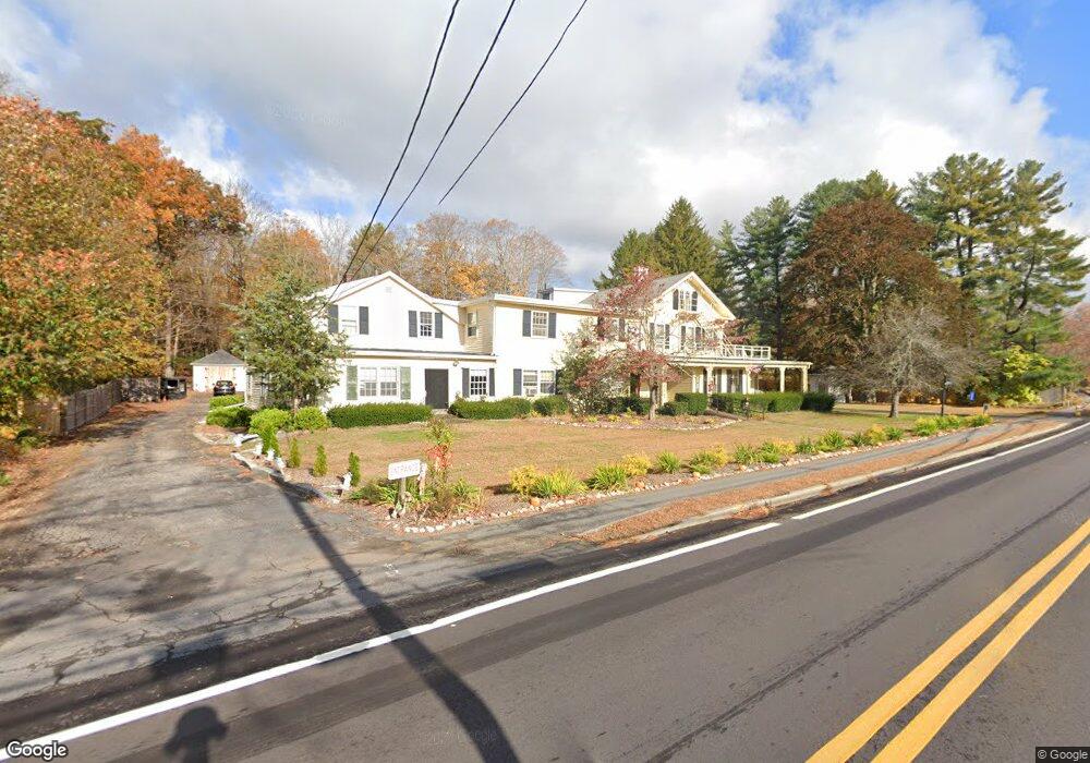
1022 West St Wrentham, MA 02093
Sheldonville NeighborhoodEstimated Value: $644,891
18
Beds
9
Baths
8,181
Sq Ft
$79/Sq Ft
Est. Value
About This Home
This home is located at 1022 West St, Wrentham, MA 02093 and is currently estimated at $644,891, approximately $78 per square foot. 1022 West St is a home located in Norfolk County with nearby schools including Delaney Elementary School, Charles E Roderick, and Mercymount Country Day School.
Ownership History
Date
Name
Owned For
Owner Type
Purchase Details
Closed on
Feb 16, 2018
Sold by
Ranieri T
Bought by
Gillys House Inc
Current Estimated Value
Home Financials for this Owner
Home Financials are based on the most recent Mortgage that was taken out on this home.
Original Mortgage
$392,000
Outstanding Balance
$331,654
Interest Rate
3.95%
Mortgage Type
New Conventional
Estimated Equity
$313,237
Purchase Details
Closed on
Dec 28, 2012
Sold by
Ranieri Donald G and Ranieri Mary E
Bought by
Ranieri T
Purchase Details
Closed on
Jan 5, 2012
Sold by
Ranieri Donald G and Ranieri Mary E
Bought by
Ranieri T
Purchase Details
Closed on
Jan 5, 2011
Sold by
Ranieri Donald G and Ranieri Mary E
Bought by
Ranieri Margaret C and Miller Catherine R
Purchase Details
Closed on
Jan 7, 2009
Sold by
Ranieri Donald G and Ranieri Mary E
Bought by
Ranieri Margaret C and Miller Catherine R
Purchase Details
Closed on
May 31, 1985
Bought by
Ranieri T
Create a Home Valuation Report for This Property
The Home Valuation Report is an in-depth analysis detailing your home's value as well as a comparison with similar homes in the area
Home Values in the Area
Average Home Value in this Area
Purchase History
| Date | Buyer | Sale Price | Title Company |
|---|---|---|---|
| Gillys House Inc | $400,000 | -- | |
| Ranieri T | -- | -- | |
| Ranieri T | -- | -- | |
| Ranieri Margaret C | -- | -- | |
| Ranieri Margaret C | -- | -- | |
| Ranieri T | -- | -- |
Source: Public Records
Mortgage History
| Date | Status | Borrower | Loan Amount |
|---|---|---|---|
| Open | Gillys House Inc | $392,000 | |
| Previous Owner | Ranieri T | $190,000 |
Source: Public Records
Tax History Compared to Growth
Tax History
| Year | Tax Paid | Tax Assessment Tax Assessment Total Assessment is a certain percentage of the fair market value that is determined by local assessors to be the total taxable value of land and additions on the property. | Land | Improvement |
|---|---|---|---|---|
| 2025 | $0 | $381,000 | $252,200 | $128,800 |
| 2024 | $6,493 | $382,300 | $252,200 | $130,100 |
| 2023 | $6,493 | $382,300 | $252,200 | $130,100 |
| 2022 | $0 | $376,900 | $252,200 | $124,700 |
| 2021 | $0 | $376,900 | $252,200 | $124,700 |
| 2020 | $6,493 | $375,900 | $237,000 | $138,900 |
| 2019 | $0 | $375,900 | $237,000 | $138,900 |
| 2018 | $6,493 | $355,800 | $229,100 | $126,700 |
| 2017 | $6,669 | $355,700 | $224,600 | $131,100 |
| 2016 | $6,628 | $357,300 | $220,200 | $137,100 |
| 2015 | $6,613 | $352,500 | $213,600 | $138,900 |
| 2014 | $6,565 | $353,900 | $209,400 | $144,500 |
Source: Public Records
Map
Nearby Homes
- 80 Carriage House Ln
- 955 Summer St
- 50 Green St
- 440 Chestnut St
- 11 Amber Dr
- 236 Williams St
- 19 Chestnut Lot 0
- 50 Heather Ln
- 39 Sumner Brown Rd
- 6 Woodchester Rd
- 50 Wamsutta Way
- 4 Evans St
- 1204 South St
- 0 Fall Ln
- 1222 South St
- 60 Grant Ave
- 732 King St
- 4 Munroe Dr
- 55 Lawrence Dr Unit 55
- 584 Washington St
- 1032 West St
- 1023 West St
- Bay 12 Townline Park Unit 11
- Bay 11 Townline Park Unit 11
- 1011 West St
- 999 West St
- 1043 West St Unit 1
- 1043 West St Unit 1043
- 995 West St
- 996 West St
- 50 Burnt Swamp Rd
- 975 West St
- 1070 West St
- 1053 West St
- 1063 West St Unit A
- 1063 West St Unit C
- 1063 West St Unit 3
- 1063 West St Unit 1
- 1063 West St Unit 2
- 1063 West St