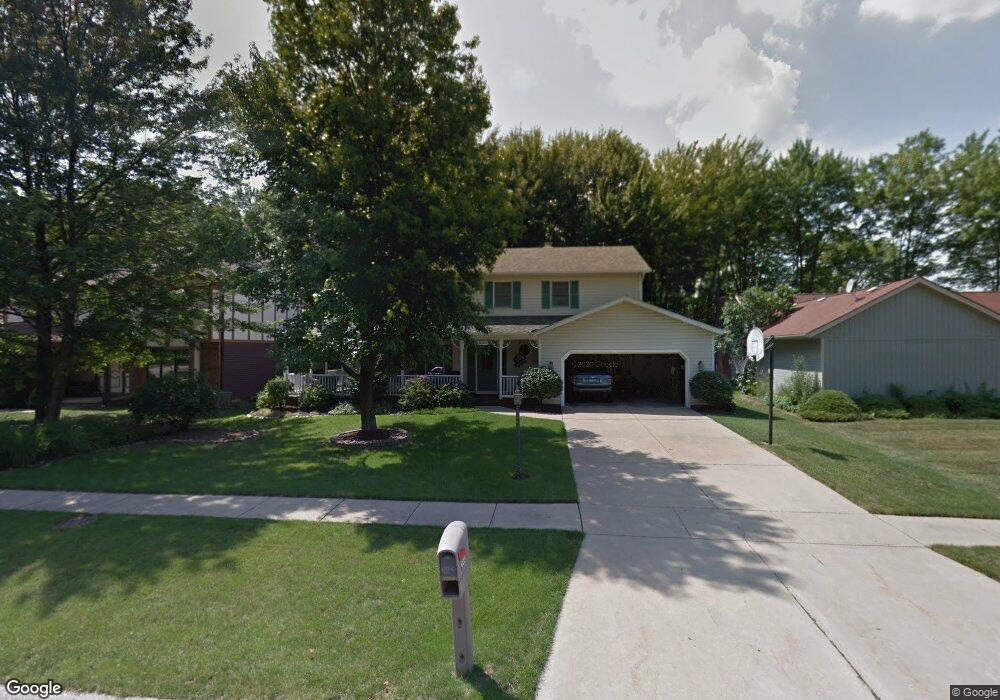
10220 Pamela Dr Strongsville, OH 44149
Estimated Value: $375,842 - $413,000
4
Beds
3
Baths
2,525
Sq Ft
$154/Sq Ft
Est. Value
About This Home
This home is located at 10220 Pamela Dr, Strongsville, OH 44149 and is currently estimated at $389,461, approximately $154 per square foot. 10220 Pamela Dr is a home located in Cuyahoga County with nearby schools including Strongsville High School, Sts Joseph & John Interparochial School, and St Mary School.
Ownership History
Date
Name
Owned For
Owner Type
Purchase Details
Closed on
Oct 30, 2012
Sold by
Amrozowicz David P and Amrozowicz Mary Ann
Bought by
Amrozowicz David P and Amrozowicz Mary Ann
Current Estimated Value
Purchase Details
Closed on
Jun 1, 1983
Bought by
Amrozowicz David P
Purchase Details
Closed on
Apr 15, 1983
Bought by
Swan Homes Inc
Purchase Details
Closed on
Jan 15, 1981
Bought by
Sunrise Development Co
Purchase Details
Closed on
Jan 1, 1978
Bought by
Tiffany Homes Inc
Create a Home Valuation Report for This Property
The Home Valuation Report is an in-depth analysis detailing your home's value as well as a comparison with similar homes in the area
Home Values in the Area
Average Home Value in this Area
Purchase History
| Date | Buyer | Sale Price | Title Company |
|---|---|---|---|
| Amrozowicz David P | -- | None Available | |
| Amrozowicz David P | -- | -- | |
| Swan Homes Inc | $18,000 | -- | |
| Sunrise Development Co | -- | -- | |
| Tiffany Homes Inc | -- | -- |
Source: Public Records
Tax History Compared to Growth
Tax History
| Year | Tax Paid | Tax Assessment Tax Assessment Total Assessment is a certain percentage of the fair market value that is determined by local assessors to be the total taxable value of land and additions on the property. | Land | Improvement |
|---|---|---|---|---|
| 2024 | $4,795 | $111,930 | $18,060 | $93,870 |
| 2023 | $5,006 | $89,120 | $17,120 | $72,000 |
| 2022 | $4,996 | $89,110 | $17,120 | $72,000 |
| 2021 | $4,956 | $89,110 | $17,120 | $72,000 |
| 2020 | $4,839 | $78,160 | $15,020 | $63,140 |
| 2019 | $4,697 | $223,300 | $42,900 | $180,400 |
| 2018 | $4,109 | $78,160 | $15,020 | $63,140 |
| 2017 | $4,029 | $69,480 | $13,370 | $56,110 |
| 2016 | $3,996 | $69,480 | $13,370 | $56,110 |
| 2015 | $3,971 | $69,480 | $13,370 | $56,110 |
| 2014 | $3,971 | $68,260 | $12,990 | $55,270 |
Source: Public Records
Map
Nearby Homes
- 20424 Scotch Pine Way
- 19890 Idlewood Trail
- 20050 Idlewood Trail
- 19997 Idlewood Trail
- 9401 Pheasant Run Place
- 10986 Fawn Meadow Ln
- 20684 Albion Rd
- 11179 Fawn Meadow Ln
- 10839 Prospect Rd
- 19240 Briarwood Ln
- 21176 Hickory Branch Trail
- 21355 Hickory Branch Trail
- 11432 Pearl Rd
- 11499 Pearl Rd Unit A106
- 10353 Oak Branch Trail
- 12385 Corinth Ct
- 8627 Courtland Dr
- 12647 Edgepark Cir
- 18433 Whitney Rd
- 0 Priem Rd
- 10228 Pamela Dr
- 10212 Pamela Dr
- 10236 Pamela Dr
- 10108 Fair Rd
- 10237 Pamela Dr
- 10274 Pamela Dr
- 10122 Fair Rd
- 10255 Pamela Dr
- Fair Rd
- 10013 Woodhurst Dr
- 10306 Pamela Dr
- 10136 Fair Rd
- 10020 Fair Rd
- 10273 Pamela Dr
- 9981 Woodhurst Dr
- 10150 Fair Rd
- 20697 Chestnut Dr
- 10338 Pamela Dr
- 9982 Fair Rd
- 9825 Hazelwood Ave