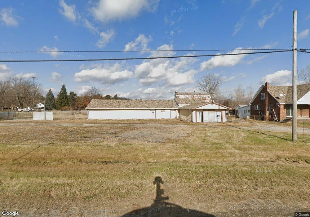
10228 Division Rd Columbus, MI 48063
Estimated Value: $329,000 - $452,000
3
Beds
1
Bath
2,600
Sq Ft
$156/Sq Ft
Est. Value
About This Home
This home is located at 10228 Division Rd, Columbus, MI 48063 and is currently estimated at $405,262, approximately $155 per square foot. 10228 Division Rd is a home located in St. Clair County with nearby schools including Will L. Lee School, Richmond Middle School, and Richmond Community High School.
Ownership History
Date
Name
Owned For
Owner Type
Purchase Details
Closed on
Sep 25, 2024
Sold by
Haly Matti
Bought by
Haly Matti Revocable Trust and Matti
Current Estimated Value
Purchase Details
Closed on
Jan 24, 2024
Sold by
Cavis Family Trust
Bought by
Matti Haly
Purchase Details
Closed on
Oct 5, 2022
Sold by
Cavis Family Trust
Bought by
Matti Haly
Purchase Details
Closed on
Jun 11, 2014
Sold by
Cavis Anthony N and Cavis Angela A
Bought by
The Cavis Family Trust
Purchase Details
Closed on
Apr 14, 2008
Sold by
Graham David P and Graham Sharon L
Bought by
Cavis Anthony N and Cavis Angie A
Home Financials for this Owner
Home Financials are based on the most recent Mortgage that was taken out on this home.
Original Mortgage
$220,559
Interest Rate
6.32%
Mortgage Type
Purchase Money Mortgage
Create a Home Valuation Report for This Property
The Home Valuation Report is an in-depth analysis detailing your home's value as well as a comparison with similar homes in the area
Home Values in the Area
Average Home Value in this Area
Purchase History
| Date | Buyer | Sale Price | Title Company |
|---|---|---|---|
| Haly Matti Revocable Trust | -- | None Listed On Document | |
| Haly Matti Revocable Trust | -- | None Listed On Document | |
| Matti Haly | $380,000 | Title One | |
| Matti Haly | $380,000 | Title One | |
| Matti Haly | -- | Title One | |
| Matti Haly | -- | Title One | |
| The Cavis Family Trust | -- | None Available | |
| Cavis Anthony N | $625,000 | None Available |
Source: Public Records
Mortgage History
| Date | Status | Borrower | Loan Amount |
|---|---|---|---|
| Previous Owner | Cavis Anthony N | $220,559 |
Source: Public Records
Tax History Compared to Growth
Tax History
| Year | Tax Paid | Tax Assessment Tax Assessment Total Assessment is a certain percentage of the fair market value that is determined by local assessors to be the total taxable value of land and additions on the property. | Land | Improvement |
|---|---|---|---|---|
| 2025 | $10,930 | $174,000 | $0 | $0 |
| 2024 | $8,527 | $234,900 | $0 | $0 |
| 2023 | $8,491 | $232,300 | $0 | $0 |
| 2022 | $8,342 | $227,800 | $0 | $0 |
| 2021 | $7,906 | $215,500 | $0 | $0 |
| 2020 | $7,906 | $223,100 | $223,100 | $0 |
| 2019 | $7,198 | $216,300 | $0 | $0 |
| 2018 | $7,059 | $182,200 | $0 | $0 |
| 2017 | $5,575 | $178,800 | $0 | $0 |
| 2016 | $6,028 | $178,800 | $0 | $0 |
| 2015 | -- | $177,800 | $177,800 | $0 |
| 2014 | -- | $155,100 | $155,100 | $0 |
| 2013 | -- | $155,100 | $0 | $0 |
Source: Public Records
Map
Nearby Homes
- 0000 Gratiot Ave
- 0 Bethuy Rd Unit Lot K 50184826
- 0 Bethuy Rd Unit Lot J 50184823
- 0 Bethuy Rd Unit 50167002
- 68242 Lake Angela Pointe
- 68373 Lake Angela Pointe
- 68198 Lake Angela Pointe
- 68152 Rosewood Ln
- 68036 Rosewood Ln
- 68034 Rosewood Ln
- 36640 Heritage Dr
- 0 Howard St
- 67649 Samuel Ct
- 68050 Main St
- 69011 Stone St
- 67799 Gleason St
- 69270 N Forest Ave
- 69446 N Forest Ave
- 35930 Washington St
- 36870 Hebel Rd
- 0 Division 'F' Unit 4747964
- 10390 Gratiot Ave
- 10494 Gratiot Ave
- 10183 Division Rd
- 10410 Gratiot Ave
- 10344 Gratiot Ave
- 10344 Gratiot Ave
- 10170 Division Rd
- 10304 Division Rd
- 10336 Gratiot Ave
- 10158 Division Rd
- 10314 Division Rd
- 10533 Gratiot Ave
- 10323 Gratiot Ave
- 10323 Gratiot Ave
- 10312 Gratiot Ave
- 0 Gratiot Ave
- 000 Gratiot Ave
- 10148 Division Rd
- 10113 Division Rd