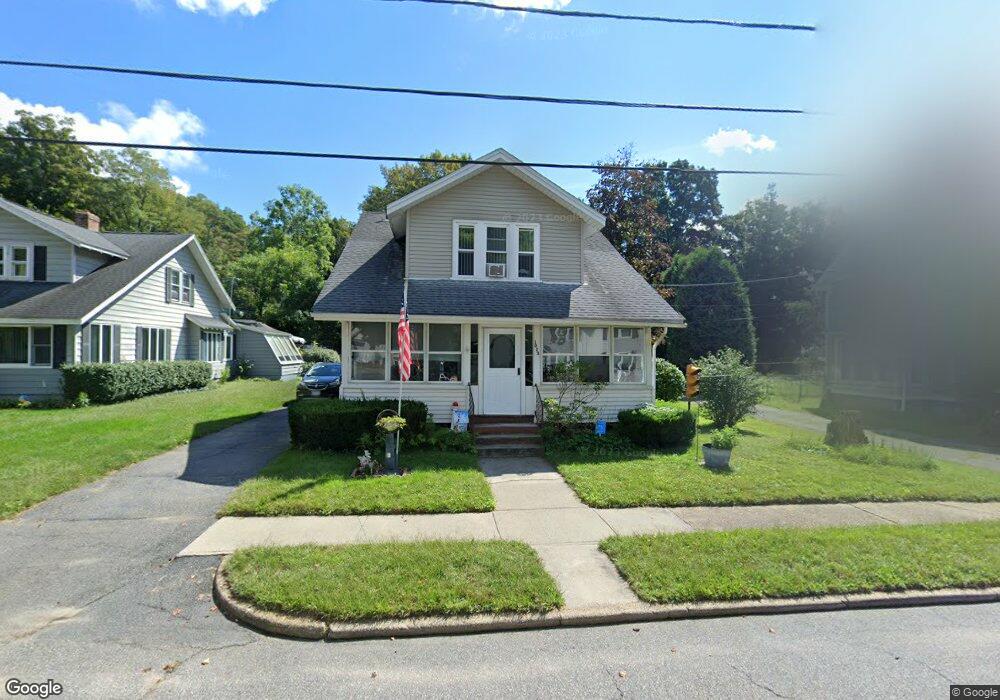
1023 Maple St Palmer, MA 01069
Estimated Value: $242,000 - $297,000
3
Beds
2
Baths
1,008
Sq Ft
$266/Sq Ft
Est. Value
About This Home
This home is located at 1023 Maple St, Palmer, MA 01069 and is currently estimated at $268,165, approximately $266 per square foot. 1023 Maple St is a home located in Hampden County with nearby schools including Old Mill Pond Elementary School, Converse Middle School, and Palmer High School.
Ownership History
Date
Name
Owned For
Owner Type
Purchase Details
Closed on
Jun 29, 2007
Sold by
Senecal Tina C
Bought by
Aldrich Bruce A and Senecal Tina C
Current Estimated Value
Purchase Details
Closed on
Dec 31, 2001
Sold by
Iadisernia Louis W
Bought by
Iadisernia Charlotte E and Senecal Tina C
Home Financials for this Owner
Home Financials are based on the most recent Mortgage that was taken out on this home.
Original Mortgage
$84,000
Interest Rate
6.61%
Mortgage Type
Purchase Money Mortgage
Create a Home Valuation Report for This Property
The Home Valuation Report is an in-depth analysis detailing your home's value as well as a comparison with similar homes in the area
Home Values in the Area
Average Home Value in this Area
Purchase History
| Date | Buyer | Sale Price | Title Company |
|---|---|---|---|
| Aldrich Bruce A | -- | -- | |
| Aldrich Bruce A | -- | -- | |
| Iadisernia Charlotte E | $105,000 | -- | |
| Iadisernia Charlotte E | $105,000 | -- |
Source: Public Records
Mortgage History
| Date | Status | Borrower | Loan Amount |
|---|---|---|---|
| Previous Owner | Iadisernia Charlotte E | $84,000 | |
| Previous Owner | Iadisernia Charlotte E | $39,500 |
Source: Public Records
Tax History
| Year | Tax Paid | Tax Assessment Tax Assessment Total Assessment is a certain percentage of the fair market value that is determined by local assessors to be the total taxable value of land and additions on the property. | Land | Improvement |
|---|---|---|---|---|
| 2025 | $3,390 | $186,800 | $52,700 | $134,100 |
| 2024 | $2,963 | $158,700 | $47,900 | $110,800 |
| 2023 | $2,897 | $149,000 | $47,900 | $101,100 |
| 2022 | $2,868 | $134,000 | $42,000 | $92,000 |
| 2021 | $2,826 | $124,900 | $46,600 | $78,300 |
| 2020 | $2,752 | $120,700 | $46,600 | $74,100 |
| 2019 | $2,672 | $120,700 | $46,600 | $74,100 |
| 2018 | $2,590 | $117,300 | $45,200 | $72,100 |
| 2017 | $2,530 | $117,300 | $45,200 | $72,100 |
| 2016 | $2,427 | $114,100 | $43,900 | $70,200 |
| 2015 | $2,354 | $114,100 | $43,900 | $70,200 |
Source: Public Records
Map
Nearby Homes
- 1242 S Main St
- 1240 S Main St
- 0 St Unit 73414881
- 7,37,38 Thorndike and Lawrence St
- Lot 8 Breckenridge St
- 62-91 Lawrence St
- Lots 39-42 Lawrence
- 405 Shearer St
- 69 E Palmer Park Dr
- 1415 Park St
- 268 Palmer Rd Unit 27
- 22-25 Macomber Rd
- 0 Hovey Rd
- 101 Ware St
- 15 Quaboag Valley Co-Op St Unit 15
- 0 Old Warren Rd
- 54-57 Breton and Calkins Rd
- 22 Pine View
- 4452 High St
- 135 Thompson St
- 1019 Maple St
- 1019 Maple St Unit 1021
- 1025 Maple St
- 1018 Maple St Unit 1020
- 29 Grove St
- 15 Grove St
- 1015 Maple St
- 1016 Maple St
- 7 Grove St
- 1011 Maple St Unit 1013
- 1011-1013 Maple St
- 1028 School St
- 1012 Maple St
- 36 Grove St
- 1010 Maple St Unit 1012
- 1010 Maple St Unit 2
- 34 Grove St
- 20 Grove St
- 16 Grove St
- 1034 School St
Your Personal Tour Guide
Ask me questions while you tour the home.