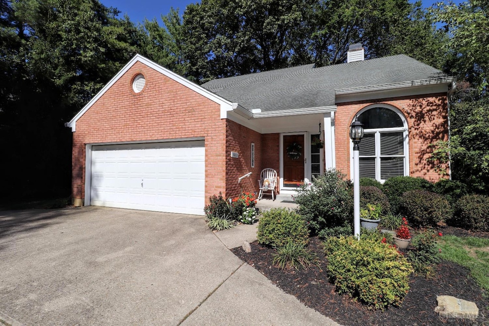
1023 Portway Dr Cincinnati, OH 45255
Estimated payment $2,397/month
Highlights
- Open-Concept Dining Room
- Deck
- Transitional Architecture
- Ayer Elementary School Rated A
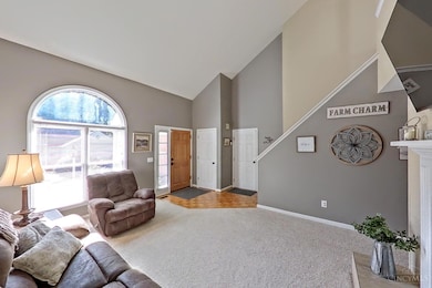
- Cathedral Ceiling
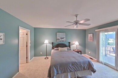
- Main Floor Bedroom
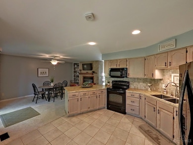
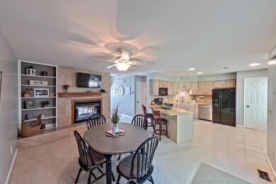
About This Home
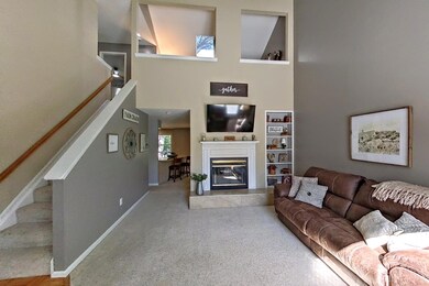
Move into your home before Christmas! You'll love the openness and brightness of this well cared for and spacious home nestled on a pretty lot at the end of a cul-de-sac in a quiet sidewalk neighborhood close to all Anderson offers. There's a vaulted ceiling in the Great Room and Loft. Warm up next to thye 2-sided woodburning fireplace in either the Great Room or Dining Room. You'll appreciate the convenience of the 1st floor primary bedroom that features an ensuite bath, large walk-in closet, and a walkout to an expansive deck across the entire back of the home and a peaceful back yard. The Dining Room is open to the kitchen and has plenty of space for family dinners and entertaining. Built-in bookcases are a classy touch in the Great Room, Dining Room and Loft overlooking the Great Room. Newer furnace and central air (2-3 years), and dishwasher ('24). Make this home your sanctuary.
Home Details
Home Type
- Single Family
Est. Annual Taxes
- $5,544
Year Built
- Built in 1989
Lot Details
- 9,888 Sq Ft Lot
- Cul-De-Sac
- Flag Lot
HOA Fees
- $21 Monthly HOA Fees
Parking
- 2 Car Attached Garage
- Front Facing Garage
- Garage Door Opener
- Driveway
Home Design
- Transitional Architecture
- Brick Exterior Construction
- Poured Concrete
- Shingle Roof
- Vinyl Siding
Interior Spaces
- 1,869 Sq Ft Home
- 2-Story Property
- Bookcases
- Cathedral Ceiling
- Ceiling Fan
- Skylights
- Recessed Lighting
- Wood Burning Fireplace
- Double Pane Windows
- Vinyl Clad Windows
- Insulated Windows
- Panel Doors
- Great Room with Fireplace
- Open-Concept Dining Room
- Dining Room with Fireplace
- Loft
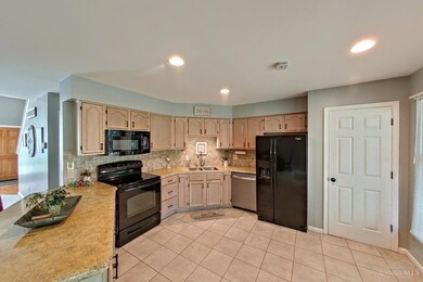
Kitchen
- Eat-In Kitchen
- Breakfast Bar
- Oven or Range
- Dishwasher
- Solid Wood Cabinet
- Disposal
Flooring
- Concrete
- Tile
Bedrooms and Bathrooms
- 3 Bedrooms
- Main Floor Bedroom
- Walk-In Closet
Laundry
- Dryer
- Washer
Unfinished Basement
- Basement Fills Entire Space Under The House
- Sump Pump with Backup
Outdoor Features
- Deck
- Porch
Utilities
- Forced Air Heating and Cooling System
- Heating System Uses Gas
- Gas Water Heater
- Cable TV Available
Community Details
- Association fees include association dues
Listing and Financial Details
- Home warranty included in the sale of the property
Map
Home Values in the Area
Average Home Value in this Area
Tax History
| Year | Tax Paid | Tax Assessment Tax Assessment Total Assessment is a certain percentage of the fair market value that is determined by local assessors to be the total taxable value of land and additions on the property. | Land | Improvement |
|---|---|---|---|---|
| 2024 | $5,545 | $101,242 | $13,087 | $88,155 |
| 2023 | $5,319 | $101,242 | $13,087 | $88,155 |
| 2022 | $4,624 | $80,017 | $10,283 | $69,734 |
| 2021 | $4,504 | $80,017 | $10,283 | $69,734 |
| 2020 | $4,569 | $80,017 | $10,283 | $69,734 |
| 2019 | $4,380 | $70,812 | $9,100 | $61,712 |
| 2018 | $4,103 | $70,812 | $9,100 | $61,712 |
| 2017 | $3,863 | $70,812 | $9,100 | $61,712 |
| 2016 | $3,560 | $64,712 | $9,100 | $55,612 |
| 2015 | $3,464 | $64,712 | $9,100 | $55,612 |
| 2014 | $3,467 | $64,712 | $9,100 | $55,612 |
| 2013 | $3,204 | $63,442 | $8,922 | $54,520 |
Property History
| Date | Event | Price | List to Sale | Price per Sq Ft |
|---|---|---|---|---|
| 11/19/2025 11/19/25 | Pending | -- | -- | -- |
| 11/08/2025 11/08/25 | Price Changed | $364,800 | -2.7% | $195 / Sq Ft |
| 10/29/2025 10/29/25 | Price Changed | $374,900 | -1.3% | $201 / Sq Ft |
| 10/24/2025 10/24/25 | Price Changed | $379,900 | -2.6% | $203 / Sq Ft |
| 10/04/2025 10/04/25 | For Sale | $389,900 | -- | $209 / Sq Ft |
Purchase History
| Date | Type | Sale Price | Title Company |
|---|---|---|---|
| Interfamily Deed Transfer | -- | None Available | |
| Warranty Deed | $159,000 | First Title Agency Inc | |
| Deed | -- | -- |
Mortgage History
| Date | Status | Loan Amount | Loan Type |
|---|---|---|---|
| Previous Owner | $115,200 | No Value Available |
Source: MLS of Greater Cincinnati (CincyMLS)
MLS Number: 1857451
APN: 500-0123-0083
Disclaimer: Certain information contained herein is derived from information provided by parties other than Homes.com. All information provided is deemed reliable, but is not guaranteed to be accurate and should be independently verified.
![]() The data relating to real estate for sale on this website comes in part from the Broker Reciprocity programs of the MLS of Greater Cincinnati, Inc.. Those listings held by brokerage firms other than Ten-X are marked with the Broker Reciprocity logo and house icon. The properties displayed may not be all of the properties available through Broker Reciprocity.
The data relating to real estate for sale on this website comes in part from the Broker Reciprocity programs of the MLS of Greater Cincinnati, Inc.. Those listings held by brokerage firms other than Ten-X are marked with the Broker Reciprocity logo and house icon. The properties displayed may not be all of the properties available through Broker Reciprocity.
IDX information is provided exclusively for personal, non-commercial use, and may not be used for any purpose other than to identify prospective properties consumers may be interested in purchasing.
Information is deemed reliable but not guaranteed.
Ten-X does not display the entire Cincinnati MLS Broker Reciprocity™ database on this web site. The listings of some real estate brokerage firms have been excluded.
Copyright 2025, MLS of Greater Cincinnati, Inc. All rights reserved
- 8303 Tidewater Ct
- 8119 Witts Meadow Ln
- 1019 Wittshire Ln
- 1082 Eight Mile Rd
- 983 Pamela Rd
- 8512 Prilla Ln
- 8240 Woodglen Dr
- 925 Pamela Dr
- 1380 Yellowglen Dr
- 1400 Sigma Cir
- 8538 Sunmont Dr
- 1269 Nordica Ln
- 1434 Castleberry Ct
- 1357 Oak Ct
- 1363 Oak Ct
- 1068 Nordyke Rd
- 8022 Stonegate Dr
- 1081 White Pine Ct
- 7922 Bar Harbor Dr
- 7926 Bar Harbor Dr
