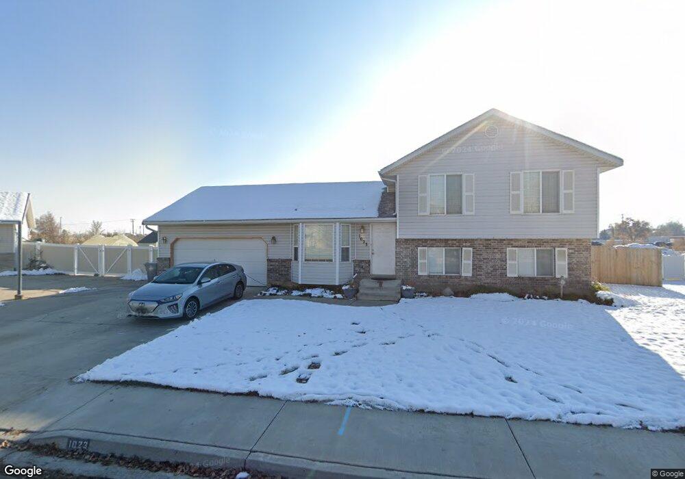
1023 W 500 N Pleasant Grove, UT 84062
Estimated Value: $477,000 - $505,000
4
Beds
3
Baths
1,650
Sq Ft
$297/Sq Ft
Est. Value
About This Home
This home is located at 1023 W 500 N, Pleasant Grove, UT 84062 and is currently estimated at $489,590, approximately $296 per square foot. 1023 W 500 N is a home located in Utah County with nearby schools including Mount Mahogany School, Pleasant Grove Junior High School, and Pleasant Grove High School.
Ownership History
Date
Name
Owned For
Owner Type
Purchase Details
Closed on
Sep 27, 2001
Sold by
Cox Charles Rich and Cox Angela
Bought by
Hailstone Matthew D and Hailstone Heidi
Current Estimated Value
Home Financials for this Owner
Home Financials are based on the most recent Mortgage that was taken out on this home.
Original Mortgage
$152,840
Outstanding Balance
$59,915
Interest Rate
6.91%
Mortgage Type
FHA
Estimated Equity
$429,676
Purchase Details
Closed on
Jul 29, 1998
Sold by
Patterson Construction Inc
Bought by
Cox Charles Rich and Cox Angela
Home Financials for this Owner
Home Financials are based on the most recent Mortgage that was taken out on this home.
Original Mortgage
$121,600
Interest Rate
6.9%
Purchase Details
Closed on
Oct 3, 1996
Sold by
Mower Douglas R and Dalton Oral T
Bought by
Patterson Construction Inc
Create a Home Valuation Report for This Property
The Home Valuation Report is an in-depth analysis detailing your home's value as well as a comparison with similar homes in the area
Home Values in the Area
Average Home Value in this Area
Purchase History
| Date | Buyer | Sale Price | Title Company |
|---|---|---|---|
| Hailstone Matthew D | -- | Old Republic Title Company | |
| Cox Charles Rich | -- | First American Title | |
| Patterson Construction Inc | -- | First American Title |
Source: Public Records
Mortgage History
| Date | Status | Borrower | Loan Amount |
|---|---|---|---|
| Open | Hailstone Matthew D | $152,840 | |
| Previous Owner | Cox Charles Rich | $121,600 |
Source: Public Records
Tax History Compared to Growth
Tax History
| Year | Tax Paid | Tax Assessment Tax Assessment Total Assessment is a certain percentage of the fair market value that is determined by local assessors to be the total taxable value of land and additions on the property. | Land | Improvement |
|---|---|---|---|---|
| 2025 | $1,799 | $234,410 | $192,600 | $233,600 |
| 2024 | $1,799 | $214,720 | $0 | $0 |
| 2023 | $1,774 | $216,700 | $0 | $0 |
| 2022 | $1,822 | $221,540 | $0 | $0 |
| 2021 | $1,594 | $295,100 | $129,000 | $166,100 |
| 2020 | $1,459 | $264,800 | $115,200 | $149,600 |
| 2019 | $1,387 | $260,200 | $111,700 | $148,500 |
| 2018 | $1,318 | $233,800 | $104,700 | $129,100 |
| 2017 | $1,321 | $124,740 | $0 | $0 |
| 2016 | $1,265 | $115,335 | $0 | $0 |
| 2015 | $1,213 | $104,720 | $0 | $0 |
| 2014 | $1,141 | $97,570 | $0 | $0 |
Source: Public Records
Map
Nearby Homes