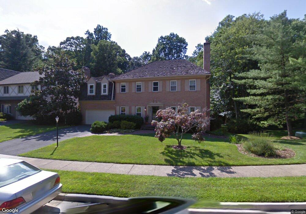
1024 Broad Branch Ct McLean, VA 22101
Estimated Value: $1,836,659 - $2,076,000
4
Beds
4
Baths
3,866
Sq Ft
$506/Sq Ft
Est. Value
About This Home
This home is located at 1024 Broad Branch Ct, McLean, VA 22101 and is currently estimated at $1,955,665, approximately $505 per square foot. 1024 Broad Branch Ct is a home located in Fairfax County with nearby schools including Churchill Road Elementary School, Cooper Middle School, and Langley High School.
Ownership History
Date
Name
Owned For
Owner Type
Purchase Details
Closed on
Jun 21, 1996
Sold by
Te Manz and Te Bessie
Bought by
Mcmasters Gregory S
Current Estimated Value
Home Financials for this Owner
Home Financials are based on the most recent Mortgage that was taken out on this home.
Original Mortgage
$400,000
Outstanding Balance
$26,045
Interest Rate
8.21%
Mortgage Type
Purchase Money Mortgage
Estimated Equity
$1,929,620
Create a Home Valuation Report for This Property
The Home Valuation Report is an in-depth analysis detailing your home's value as well as a comparison with similar homes in the area
Home Values in the Area
Average Home Value in this Area
Purchase History
| Date | Buyer | Sale Price | Title Company |
|---|---|---|---|
| Mcmasters Gregory S | $550,000 | -- |
Source: Public Records
Mortgage History
| Date | Status | Borrower | Loan Amount |
|---|---|---|---|
| Open | Mcmasters Gregory S | $400,000 |
Source: Public Records
Tax History Compared to Growth
Tax History
| Year | Tax Paid | Tax Assessment Tax Assessment Total Assessment is a certain percentage of the fair market value that is determined by local assessors to be the total taxable value of land and additions on the property. | Land | Improvement |
|---|---|---|---|---|
| 2025 | $19,190 | $1,751,410 | $724,000 | $1,027,410 |
| 2024 | $19,190 | $1,577,240 | $614,000 | $963,240 |
| 2023 | $17,152 | $1,446,990 | $569,000 | $877,990 |
| 2022 | $17,055 | $1,421,350 | $556,000 | $865,350 |
| 2021 | $16,431 | $1,339,830 | $540,000 | $799,830 |
| 2020 | $16,385 | $1,327,420 | $540,000 | $787,420 |
| 2019 | $16,200 | $1,310,850 | $540,000 | $770,850 |
| 2018 | $15,912 | $1,289,850 | $519,000 | $770,850 |
| 2017 | $14,992 | $1,237,080 | $516,000 | $721,080 |
| 2016 | $14,397 | $1,189,350 | $496,000 | $693,350 |
Source: Public Records
Map
Nearby Homes
- 1120 Kensington Rd
- 1146 Wimbledon Dr
- 1109 Ingleside Ave
- 6884 Churchill Rd
- 6910 Bright Ave
- 1104 Sharon Ct
- 1060 Harvey Rd
- 6625 Weatheford Ct
- 6619 Madison Mclean Dr
- 7000 Hector Rd
- 909 Douglass Dr
- 7011 Elizabeth Dr
- 6804 Benjamin St
- 6800 Fleetwood Rd Unit 705
- 1316 Calder Rd
- 6900 Fleetwood Rd Unit 600
- 6911 Elm St
- 7009 Benjamin St
- 1171 Chain Bridge Rd
- 6634 Brawner St
- 1026 Broad Branch Ct
- 1023 Broad Branch Ct
- 1028 Broad Branch Ct
- 1016 Broad Branch Ct
- 1025 Broad Branch Ct
- 1021 Broad Branch Ct
- 1019 Broad Branch Ct
- 1027 Broad Branch Ct
- 1015 Broad Branch Ct
- 1014 Broad Branch Ct
- 1030 Broad Branch Ct
- 1029 Broad Branch Ct
- 1013 Broad Branch Ct
- 1004 Broad Branch Ct
- 1009 Broad Branch Ct
- 1034 Broad Branch Ct
- 1044 Douglass Dr
- 1033 Broad Branch Ct
- 1035 Broad Branch Ct
- 1000 Broad Branch Ct