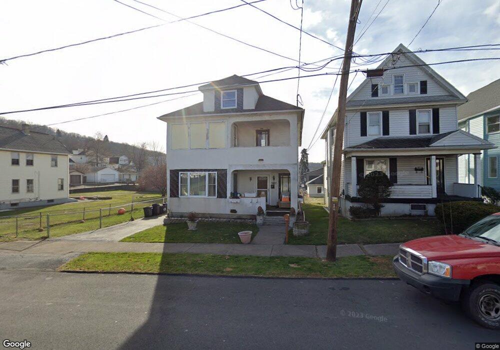
1024 Maple St Scranton, PA 18505
South Side NeighborhoodEstimated Value: $67,065 - $243,000
Studio
--
Bath
--
Sq Ft
8,930
Sq Ft
About This Home
This home is located at 1024 Maple St, Scranton, PA 18505 and is currently estimated at $174,516. 1024 Maple St is a home located in Lackawanna County with nearby schools including McNichols Plaza Elementary School, South Scranton Intermediate, and West Scranton High School.
Ownership History
Date
Name
Owned For
Owner Type
Purchase Details
Closed on
Dec 2, 2005
Sold by
Partyka Michael C and Partyka Kathleen
Bought by
Lafrance Renne M Conway and Lafrance Patricia
Current Estimated Value
Home Financials for this Owner
Home Financials are based on the most recent Mortgage that was taken out on this home.
Original Mortgage
$137,280
Outstanding Balance
$83,683
Interest Rate
7.84%
Mortgage Type
Adjustable Rate Mortgage/ARM
Estimated Equity
$90,833
Create a Home Valuation Report for This Property
The Home Valuation Report is an in-depth analysis detailing your home's value as well as a comparison with similar homes in the area
Home Values in the Area
Average Home Value in this Area
Purchase History
| Date | Buyer | Sale Price | Title Company |
|---|---|---|---|
| Lafrance Renne M Conway | $132,000 | None Available |
Source: Public Records
Mortgage History
| Date | Status | Borrower | Loan Amount |
|---|---|---|---|
| Open | Lafrance Renne M Conway | $137,280 |
Source: Public Records
Tax History
| Year | Tax Paid | Tax Assessment Tax Assessment Total Assessment is a certain percentage of the fair market value that is determined by local assessors to be the total taxable value of land and additions on the property. | Land | Improvement |
|---|---|---|---|---|
| 2025 | $3,674 | $11,500 | $1,700 | $9,800 |
| 2024 | $3,356 | $11,500 | $1,700 | $9,800 |
| 2023 | $3,356 | $11,500 | $1,700 | $9,800 |
| 2022 | $3,282 | $11,500 | $1,700 | $9,800 |
| 2021 | $3,282 | $11,500 | $1,700 | $9,800 |
| 2020 | $3,220 | $11,500 | $1,700 | $9,800 |
| 2019 | $3,029 | $11,500 | $1,700 | $9,800 |
| 2018 | $3,029 | $11,500 | $1,700 | $9,800 |
| 2017 | $2,975 | $11,500 | $1,700 | $9,800 |
| 2016 | $891 | $11,500 | $1,700 | $9,800 |
| 2015 | $1,899 | $11,500 | $1,700 | $9,800 |
| 2014 | -- | $11,500 | $1,700 | $9,800 |
Source: Public Records
Map
Nearby Homes
- 1030 Meadow Ave
- 955 E Elm St
- 723 Moltke Ave
- 623 Crown Ave
- 16 Cherry St
- 1338 E Elm St
- 717 E Elm St Unit REAR
- 0 Froude Ave
- 1019 S Webster Ave
- 1024 S Webster Ave
- 719 S Webster Ave
- 635 E Elm St Unit Rear
- 417 S Irving Ave
- 1425 Brook St
- 616 Birch St
- 613 E Locust St
- 910 Orchard St
- 626 Fig St
- 217 Crown Ave
- 1017 Hamm Ct
- 1022 Maple St
- 1028 Maple St
- 1020 Maple St
- 1016 Maple St
- 1015 E Elm St Unit R
- 1015 E Elm St
- 1030 Maple St
- 1007 Stafford Ave
- 1007 Stafford Ave
- 1007 Stafford Ave
- 1023 E Elm St
- 1035 E Elm St
- 1012 Boland Ct
- 1019 1/2 Maple St
- 1012 Maple St
- 1008 Meadow Ave
- 1039 E Elm St
- 1010 Meadow Ave
- 1012 Meadow Ave
- 1014 Meadow Ave
Your Personal Tour Guide
Ask me questions while you tour the home.