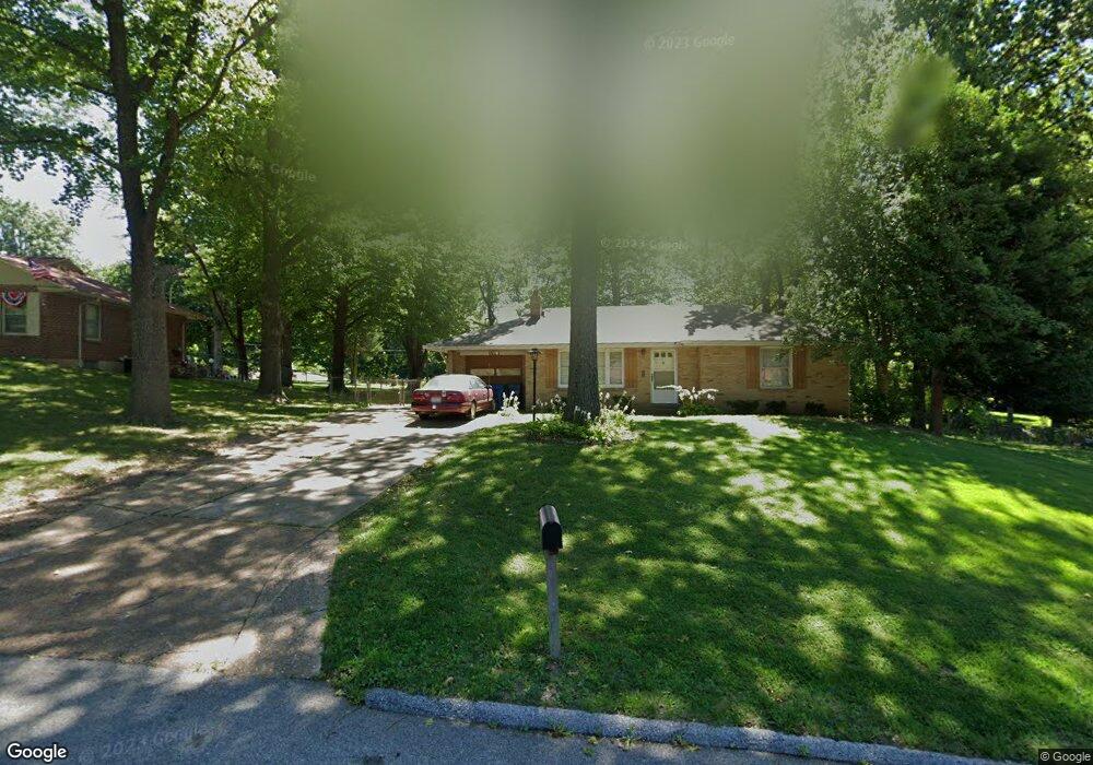
1024 Thatcher Ave Saint Louis, MO 63135
Estimated Value: $161,000 - $187,000
3
Beds
3
Baths
1,510
Sq Ft
$119/Sq Ft
Est. Value
About This Home
This home is located at 1024 Thatcher Ave, Saint Louis, MO 63135 and is currently estimated at $179,050, approximately $118 per square foot. 1024 Thatcher Ave is a home located in St. Louis County with nearby schools including Griffith Elementary School, Ferguson Middle School, and McCluer High School.
Ownership History
Date
Name
Owned For
Owner Type
Purchase Details
Closed on
Jul 18, 2003
Sold by
Gipson Gracie J
Bought by
Helbling Mark Randall and Helbling Donna Jean
Current Estimated Value
Home Financials for this Owner
Home Financials are based on the most recent Mortgage that was taken out on this home.
Original Mortgage
$82,900
Outstanding Balance
$35,484
Interest Rate
5.35%
Mortgage Type
Purchase Money Mortgage
Estimated Equity
$143,566
Purchase Details
Closed on
Dec 6, 2001
Sold by
Gipson Gracie J and Wayne Gipson M
Bought by
Gipson Gracie J and Gracie J Gipson Living Trust
Create a Home Valuation Report for This Property
The Home Valuation Report is an in-depth analysis detailing your home's value as well as a comparison with similar homes in the area
Home Values in the Area
Average Home Value in this Area
Purchase History
| Date | Buyer | Sale Price | Title Company |
|---|---|---|---|
| Helbling Mark Randall | $129,900 | Capital Title | |
| Gipson Gracie J | -- | -- |
Source: Public Records
Mortgage History
| Date | Status | Borrower | Loan Amount |
|---|---|---|---|
| Open | Helbling Mark Randall | $82,900 | |
| Closed | Helbling Mark Randall | $34,000 |
Source: Public Records
Tax History
| Year | Tax Paid | Tax Assessment Tax Assessment Total Assessment is a certain percentage of the fair market value that is determined by local assessors to be the total taxable value of land and additions on the property. | Land | Improvement |
|---|---|---|---|---|
| 2025 | $2,836 | $32,080 | $5,400 | $26,680 |
| 2024 | $2,836 | $29,460 | $6,750 | $22,710 |
| 2023 | $3,020 | $29,460 | $6,750 | $22,710 |
| 2022 | $2,621 | $22,590 | $4,310 | $18,280 |
| 2021 | $2,607 | $22,590 | $4,310 | $18,280 |
| 2020 | $2,456 | $19,990 | $5,870 | $14,120 |
| 2019 | $2,419 | $19,990 | $5,870 | $14,120 |
| 2018 | $2,344 | $17,800 | $4,730 | $13,070 |
| 2016 | $2,535 | $19,820 | $3,970 | $15,850 |
Source: Public Records
Map
Nearby Homes
- 1102 Thatcher Ave
- 506 Averill Ave
- 511 Averill Ave
- 332 Argent Ave
- 1051 Smith Ave
- 512 Coppinger Dr
- 905 Roussilon Ct
- 610 Superior Dr
- 705 Palace Ct
- 1354 Stein Rd
- 631 Robert Ave
- 1355 Stein Rd
- 1372 Heydt Ave
- 308 Superior Dr
- 1330 Chambers Rd
- 820 N Elizabeth Ave
- 309 N Floridale Ave
- 4 S Dellwood Ave
- 700 N Elizabeth Ave
- 212 Millman Dr
- 1032 Thatcher Ave
- 1014 Thatcher Ave
- 1001 Thatcher Ave
- 1002 Thatcher Ave
- 1031 Thatcher Ave
- 1112 Thatcher Ave
- 1101 Thatcher Ave
- 1111 Thatcher Ave
- 433 Day Dr
- 1205 Kroeger Dr
- 1201 Kroeger Dr
- 1124 Thatcher Ave
- 936 Smithshire Ave
- 1013 Hutton Place
- 938 Thatcher Ave
- 1209 Kroeger Dr
- 1021 Robert Ave
- 931 Thatcher Ave
- 1019 Robert Ave
- 1014 Hutton Place
Your Personal Tour Guide
Ask me questions while you tour the home.