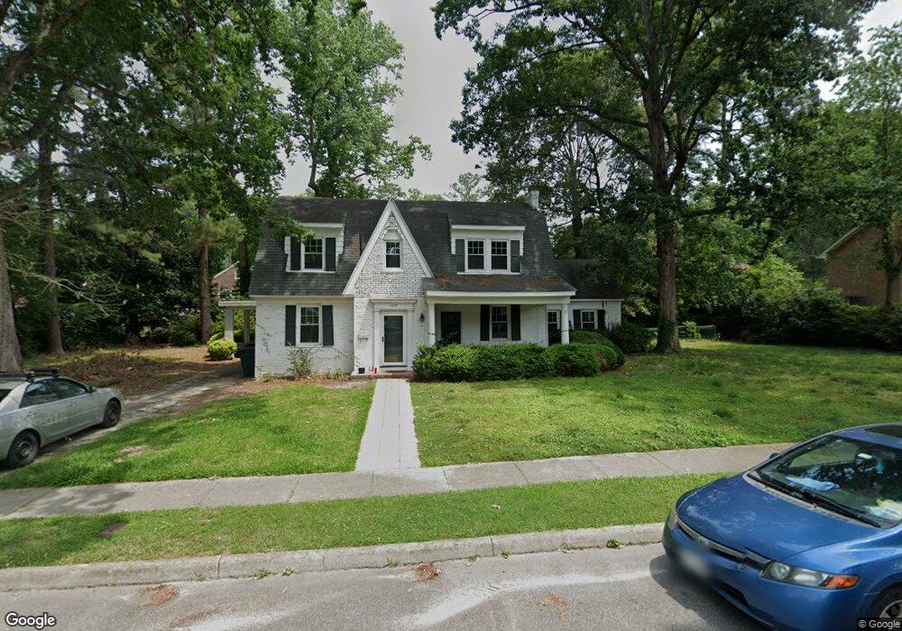
1024 Virginia Ave Suffolk, VA 23434
Holy Neck NeighborhoodEstimated Value: $348,000 - $424,000
5
Beds
3
Baths
2,776
Sq Ft
$138/Sq Ft
Est. Value
About This Home
This home is located at 1024 Virginia Ave, Suffolk, VA 23434 and is currently estimated at $383,624, approximately $138 per square foot. 1024 Virginia Ave is a home located in Suffolk City with nearby schools including Elephant's Fork Elementary School, King's Fork Middle School, and King's Fork High School.
Ownership History
Date
Name
Owned For
Owner Type
Purchase Details
Closed on
Dec 29, 2021
Sold by
Hampton Roads Estate Development Llc
Bought by
Stuer Erik George and Stuer Alison
Current Estimated Value
Home Financials for this Owner
Home Financials are based on the most recent Mortgage that was taken out on this home.
Original Mortgage
$362,600
Outstanding Balance
$332,123
Interest Rate
3.11%
Mortgage Type
VA
Estimated Equity
$51,501
Purchase Details
Closed on
Sep 4, 2020
Sold by
Markham Patsy B
Bought by
Hampton Roads Estate Development Llc
Create a Home Valuation Report for This Property
The Home Valuation Report is an in-depth analysis detailing your home's value as well as a comparison with similar homes in the area
Home Values in the Area
Average Home Value in this Area
Purchase History
We collect this data history from publicly available records. To have your information removed, we recommend requesting removal directly through your county’s website.
| Date | Buyer | Sale Price | Title Company |
|---|---|---|---|
| Stuer Erik George | $350,000 | Title Quest | |
| Hampton Roads Estate Development Llc | $170,000 | Attorney |
Source: Public Records
Mortgage History
We collect this data history from publicly available records. To have your information removed, we recommend requesting removal directly through your county’s website.
| Date | Status | Borrower | Loan Amount |
|---|---|---|---|
| Open | Stuer Erik George | $362,600 |
Source: Public Records
Tax History
| Year | Tax Paid | Tax Assessment Tax Assessment Total Assessment is a certain percentage of the fair market value that is determined by local assessors to be the total taxable value of land and additions on the property. | Land | Improvement |
|---|---|---|---|---|
| 2025 | $450 | $363,500 | $77,900 | $285,600 |
| 2024 | $450 | $351,800 | $77,900 | $273,900 |
| 2023 | $4,157 | $330,700 | $77,900 | $252,800 |
| 2022 | $3,120 | $286,200 | $70,800 | $215,400 |
| 2021 | $3,020 | $272,100 | $56,700 | $215,400 |
| 2020 | $2,733 | $246,200 | $56,700 | $189,500 |
| 2019 | $2,733 | $246,200 | $56,700 | $189,500 |
| 2018 | $2,794 | $239,600 | $56,700 | $182,900 |
| 2017 | $2,564 | $239,600 | $56,700 | $182,900 |
| 2016 | $2,564 | $239,600 | $56,700 | $182,900 |
| 2015 | $1,341 | $248,400 | $56,700 | $191,700 |
| 2014 | $1,341 | $248,400 | $56,700 | $191,700 |
Source: Public Records
Map
Nearby Homes
- 1103 Pine Valley Dr
- 921 Howard Place
- 908 Virginia Ave
- 213 Bosley Ave
- 301 S Broad St
- 109 Bosley Ave
- 117 Bute St
- 622 Mason Ave
- 718 Battery Ave
- 204 Bute St
- 112 Linden Ave
- 907 Mckinley Ave
- 408 Saint James Ave
- 212 Saint James Ave
- 655 3rd Ave
- 118 Saint James Ave
- 215 Wellons St
- 552 2nd Ave
- 435 Wellons St
- 433 Wellons St
- 1022 Virginia Ave
- 1027 Maryland Ave
- 1017 Maryland Ave
- 1030 Virginia Ave
- 1027 Virginia Ave
- 1025 Virginia Ave
- 1020 Virginia Ave
- 1029 Maryland Ave
- 1015 Maryland Ave
- 1029 Virginia Ave
- 1015 Virginia Ave
- 402 Princeton Rd
- 1013 Maryland Ave
- 1101 Lake Point Ln
- 1026 Pennsylvania Ave
- 1028 Pennsylvania Ave
- 1020 Pennsylvania Ave
- 1011 Virginia Ave
- 1018 Maryland Ave
- 1100 Lake Point Ln
Your Personal Tour Guide
Ask me questions while you tour the home.